Showing posts with label South America. Show all posts

Monday, March 31, 2025

BOLIVIA: Unfinished Business--Return Trip by Guest Poster Owen Floody

Flamingos, Laguna Colorada, Bolivia

With many thanks to our friend Owen Floody for another exceptional contribution to The Intrepid Tourist. He writes:

Regular readers of this blog may recall my description of a June 2024 trip that surveyed the Bolivian highlands. That was a great trip. One reflection of this was that it left me wanting more, of exhibits that deserved more time than available in June and of locations or populations that deserve to be seen in more than one season.

My follow-up trip was relatively brief, running from 2/21/25 to 3/3/25.  All arrangements were made through Lucia Berrios, of Sendas Altas in La Paz. She was terrific. My major stops included La Paz, the Salar de Uyuni, the Desierto de Siloli, and Laguna Colorada.  Anyone interested in duplicating any part of this trip should be aware that the altitudes of these sites range between 12,000 and 14,600 feet.  some shortness of breath and some colder weather than the month of the year might predict.

Mask at the Museo Nacional de Etnografia y Folkore, La Paz, Bolivia.

My major goal in revisiting La Paz was to spend more time in the excellent Museo Nacional de Etnografia y Folklore (Musef).  

Mask.

This museum has outstanding displays of fabrics characteristic of Bolivia’s different regions and of a great variety of ritualistic masks such as appear in carnivals, festivals and other religious ceremonies.  I had great fun photographing many more of the latter than I can share here.

Sunset, Salar de Uyuni.

The Salar de Uyuni is a huge (4,100 sq mi) salt flat. It is mesmerizing at any time, but its character changes entirely across the seasons.  In the dry season (as I saw it in June), it is a seemingly endless flat expanse of brilliantly white salt. How such a uniform and seemingly impoverished landscape can be so attractive I don’t know, but you will have to consult the photos from my earlier column if you’re in doubt.

Salar de Uyuni.

In any case, I think that it may be in the wet season that the Salar shines most brightly.  Now, much or all of it is transformed into a huge shallow lake.  This has the potential to perfectly reflect the sky during sunrises, blue-sky afternoons, sunsets, and, perhaps especially, at night.  My efforts to capture the Milky Way were limited by rookie mistakes plus higher winds and more low clouds than expected.  Even so, this left so many wonderful scenes that I enjoyed myself far too much for complaint.

Flamingos.

My third major goal for this trip was to observe and photograph the flamingos at Laguna Colorada as they gathered in huge numbers for breeding.  There should be three species present (Andean, Chilean, James) but the second of these was hiding from me.  

Flamingos.

Nevertheless, it was great fun trying to capture these striking birds as they interacted in dense groups or celebrated their grace in flight, especially low over the striking waters of the Laguna.

Desert landscape, Bolivia.

Finally, effort of the sort that I expended (it’s just so hard taking all these photos!) deserves some reward and my unexpected bonus took the form of the succession of jaw-dropping desert landscapes that we passed through on our return from the Laguna Colorada to Uyuni.  I’m sure that my guide and driver were grateful that I let them make any progress at all between desperate pleas for “just one more shot.”  Is that what they meant as they cried “No mas. No mas."?

Monday, January 30, 2023

THE IDAHO POTATO MUSEUM: NO SMALL POTATOES, Guest Post by Caroline Hatton at The Intrepid Tourist

Idaho Potato Museum, Blackfoot, Idaho. Many visitors want their photo taken with the big baked potato.

My friend Caroline Hatton, a children’s writer and frequent contributor to this blog, immersed herself in the world of potatoes and took the photos in this post in October 2022.

If you happen to be driving around Idaho, consider visiting the Idaho Potato Museum in the town of Blackfoot, the Potato Capital of the World, on Interstate 15. I spent an hour there enjoying a wealth of information about the humble, yet glorious potato, and admiring the quality of the displays.

Left: 1930s McCormick potato cultivator; Middle: 1930s Oilver one-row pick planter to be pulled by two horses; Right: 1900s sulkey plow to be pulled by two horses.

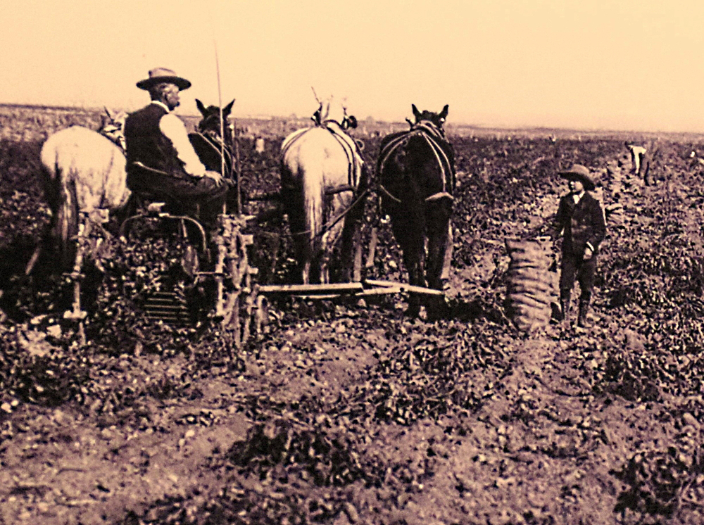
The museum is located in a former train depot, an old building next to railroad tracks. Even before entering, I got to see a number of antique agricultural implements displayed outdoor. Developed by potato growers, the earliest ones were pulled by up to four horses.

1930s Pugh one-row potato harvester to be pulled by two horses.

Besides the fact that I love rust for its look, hints of stories past, and photo opportunities, I had fun visualizing how the contraptions might work. The harvester in the above photo, when pulled forward, would drive the shovel-like front end into the soil, digging up potatoes. As they “climbed” onto the shovel, potatoes dug-up later would push potatoes dug-up earlier toward the back, off the shovel, up a conveyor belt of metal rungs gently sloping up. The bumping and bouncing would perhaps shake dirt off the potatoes. At the top of the conveyor belt, the potatoes would tumble into a larger receptacle.

The potato originated in the Andes in South America, where the Inca potato footplow or chakitailla, was used long before the 15th century and is still in use today.

The museum is small but stuffed with historical, scientific and commercial info. The potato originated in the Andes in South America where native peoples cultivated it around 200 BC. In the 1500s, Spanish conquistadors seeking gold reached Peru. They brought home a treasure: the potato. In the 1600s, it spread through Europe, Africa, China, India, and Russia, and from Ireland to Bermuda, then Virginia. The first recorded potato planting in North America was in Nova Scotia, on the Atlantic coast of Canada, in 1623.

Four horses pull a three-row potato planter designed and built by a grower, around 1935.

Today potatoes are grown in all 50 U.S. states. Idaho offers ideal potato growing conditions: a light volcanic ash soil, aquifer water for irrigation, hot days and cool nights in the summer, and a network of railroads to take potatoes to markets.

Left side: Colorado potato beetle stamps, postcards, and postmarks to educate the public about this pest. Right side:  Stamps featuring a potato merchant (top left) or potatoes.

Irish stamp commemorating the Irish Potato Famine of 1845-1850.

Of some 125 potato-growing countries around the world, the five top producers are China, India, Russia, Ukraine, and the United States. The potato changed the world and made it to Mars, at least in the movie, “The Martian.”

Half of the museum's collection of stove-top potato bakers.

One third of the museum's collection of sour cream dishes.

The museum exhibits include a collection of collections (potato peelers, stove-top bakers, sour cream ceramic dishes, what may well be the largest collection of potato mashers in the world, postage stamps, toys, vintage posters of science activities for children…) and record-setting potato items (such as the largest potato chip ever made, a Pringle listed in the Guinness Book of World Records, and a bronze sculpture replica of the largest potato ever grown in Idaho).

The gift shop sells lots of potato-themed T-shirts, souvenirs (potato peelers), and food items (potato soup or pancake mixes, seasonings). The café serves baked potatoes best ordered hours in advance so they’re ready when you are. It’s a few dollars more for access to the toppings bar, or for the topping of the day for fearless gourmets. For smaller appetites, the menu includes French fries, potato cupcakes and potato ice-cream.

I didn’t eat at the café, but visiting the Idaho Potato Museum inspired me to reminisce about yummy potato dishes I tasted in my travels (such as plokkfiskur in Iceland, a fish and potato casserole) and plan to make them at home (any day now).

All text and photos, copyright Caroline Arnold. www.theintrepidtourist.blogspot.com


Monday, November 15, 2021

From EMPANADAS to PISCO SOURS: Enjoying Chile’s Favorite Foods

 52 Places to Go: Week 46

Individual bowls of Pastel de Choclo, a favorite Chilean dish, ready to bake in the clay oven.
On our recent trip to Chile it seemed that every meal was a feast–ranging from sumptuous hotel buffets to large family holiday parties to picnics in the country to meals in local restaurants–each time giving us tastes of delicious Chilean foods.
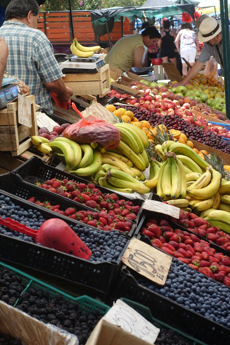
Blackberries, blueberries, strawberries and more fill the summertime farmer's markets.
It was December, the beginning of the southern summer, and the markets, or ferias, were full of juicy, locally grown, ripe fruits and vegetables. Many meals were eaten outdoors, often cooked on a barbecue or in a woodburning clay oven (horno.) And every meal included side dishes of tomatoes (tomates, always peeled), lettuce (lechuga), sliced cucumbers (pepinos) and avocados (palta.)
Typical side dishes. String beans, julienned and served as a cold salad, are a traditional Christmas dish.
A classic dish of Chile is pastel de choclo, a kind of casserole made of beef, chicken, onions, olives, raisins, and a wedge of hard boiled egg, which is then covered in a corn pudding topping and baked in a clay oven. We had pastel de choclo at a family party where guests formed an assembly line to prepare the ingredients. Each serving was cooked in the outdoor clay oven in its own ceramic bowl and then served steaming hot at a long picnic table.
Humitas. They can be made savory, sweet, or sweet and sour, served with added sugar, chile pepper, salt and paprika
The same corn mixture was used to make humitas, similar to tamales, but cooked in fresh rather than dried corn husks. I helped to make the humitas–my job was to secure the husks with a string made from a thin strip of a long leaf, making them look like fat bowties. The humitas were then steamed in a large pot on top of the stove.
Empanadas ready to bake.
Another classic dish of Chile, and elsewhere in South America, is the empanada, a kind of individual meat pie. They are fried or baked (empadanas del horno.)  Empanadas can be filled with meat, cheese, vegetables or other ingredients, but the typical filling in Chile is pino, a meat mixture made of beef, onions and herbs.
Clay oven with  empanadas inside.
During our trip, we spent three days in the country where our son-in-law’s father lives, enjoying fresh milk and vegetables every day from his neighbor’s farm and eating homemade empanadas.
Roadside stand for "The place where you can buy houseplants, beans, tomatoes, and lettuce."
The project of the visit was not only to make the empanadas (I helped roll the dough) but to build the clay oven!
At another family party during our trip, the main dish was cocimiento, a rich stew of vegetables, beef, chicken, fish and seafood (clams and mussels), flavored with wine and cooked slowly in a large pot over a barbecue. It is a bit like paella without the rice. Fish is delicious in Chile and we enjoyed it at several meals during our stay. With a coastline 2,653 miles long, a wide assortment of fish and seafood is always fresh and available.
"The King of Mote con Huesillo" offers drinks at his stand in the main plaza in Temuco. In the background are Chilean palm trees, whose flowers are used by bees to make honey.
Mote con Huesillo. The barley and peach sink to the bottom.
A typical summer drink in Chile is called mote con huesillo, made from dried peaches soaked in water to make a kind of tea, to which sugar and cooked barley is added. On a warm day it is very refreshing!
Enjoying a cafe helado.

On one of our restaurant visits my grandchildren ordered café helados another favorite Chilean treat. It sounds like it should be iced coffee, but café helado is actually an ice cream soda made with coffee, ice cream, and topped with whipped cream and wafer cookies–more like a dessert than a drink!
And, of course, on New Year’s Eve we drank the classic pisco sours, a lemon flavored drink similar to a whiskey sour, but flavored instead with pisco, a distilled alcohol made from grapes that is unique to Peru and Chile. (My only photos are of empty glasses so you'll have to imagine what our pisco sours looked like!)
And these are just a sample of Chile's delicious foods!  

This article first appeared 2/4/19

All text and photos copyright by Caroline Arnold.


Monday, February 22, 2021

HIKING THE ANDES, the HUAYHUASH TREK: Owen’s Peruvian Adventures, Part 2, Guest Post by Owen Floody at The Intrepid Tourist


Week 8: 52 Places to Go
Glacial Lakes on the Huayhuash Circuit, Peru
In 2017 our friend Owen Floody was in the midst of a series of three treks in Peru--Machu Picchu in May 2015 (Part 1 of Owen's Peruvian Adventures), Huayhuash in July 2015 (Part 2)--and Cordillera Blanca in mid-2017. Owen recently retired from a career of teaching and research at Bucknell University in Pennsylvania. He has always been an avid photographer and in his retirement has taken numerous trips that allow him to pursue his passion. He is a frequent contributor to The Intrepid Tourist. Here is the report of his Huayhuash trek and a few of his excellent photographs.
One of our camps.
The Huayhuash Range (Cordillera Huayhuash, pronounced “why wash”) is a compact cluster of mountains in the Peruvian Andes, approximately 225 miles from Lima.  It only extends over about 20 miles but contains more than 20 peaks, six of which exceed 6000 meters (19,685 ft) in height.  One of these is Siula Grande, the scene of the adventure described by Joe Simpson in the book and movie “Touching the Void.”
Our pack animals awaiting their day’s assignments.
My trek encircled much of the range, covering roughly 85 miles in 12 days.  As the area is very remote and sparsely populated (e.g., we never did pass through a village), we camped throughout, though the excellent support provided by our tour operator, Peruvian Andes Adventures (PAA), freed us of many of the normal rigors of camping: We were able to hike with just day packs, avoid the hassle of setting up or breaking down camps, and enjoy great meals all due to the efforts of the PAA staff and animals.
On the Huayhuash Track
Though the distance we covered may suggest a rigorous trek, the real challenge was in the altitude.  Most of our time was spent above 13,000 feet and most days saw us crossing at least one pass exceeding 15,000 feet, the highest of these at 16,400 feet.  One can prepare for some aspects of such a trek with an appropriately challenging exercise program, ideally including a healthy dose of actual hiking wherever you can find significant ascents and descents.  But how can most of us prepare for altitudes such as encountered here? 
Day hike from Huaraz
What I did was to arrive in Huaraz (the trek’s starting point and PAA’s base) four days early and then take full advantage of the many half-day and day hikes offered by PAA.  These covered beautiful ground and were graded in difficulty, making it possible to put together a package of pre-trek acclimatization hikes that were manageable and enjoyable, and that very much helped me to prepare for what was to come.
Soaring snow-covered peaks of the Andes and wetlands
The scenery encountered on this trek was spectacular, the most impressive of any of the seven major treks that I’ve done. Many of the types of scenes that we enjoyed are the ones that you would predict, i.e., soaring snow-covered peaks, high mountain passes, pristine valleys and meadows, wetlands.  But the Huayhuash is especially well known for its beautiful glacial lakes.  Some of these treated us to the sights and sounds of repeated avalanches. And many, if not all, presented an array of contrasting and beautiful colors. 
Avalanche
Altogether, then, this trek around the Huayhuash circuit provided an outstanding visual feast.  But this did come at the cost of considerable effort.  Why go to the trouble of trekking, especially when so many outstanding scenes can be seen from roads?  One answer is that the Huayhuash and like destinations are so remote as to be accessible in few ways other than by foot. 
 
All text and photographs copyright by Caroline Arnold at the Intrepid Tourist


Monday, January 25, 2021

EASTER ISLAND'S GIANT STATUES: How Did They Move Them? by Caroline Arnold at The Intrepid Tourist

Easter Island's Giant Statues (Moai)

WEEK 4: 52 Places to Go

The first European visitor to Easter Island was a Dutch sea caption, Jacob Roggeveen, who landed on April 5, 1722.  In the tradition of his time, he named his “discovery” for the day of his arrival, which was Easter Sunday.   Today, the island is known both as Easter Island (Isla de Pascua in Spanish) and Rapa Nui, a Polynesian name given to it in the nineteenth century by Tahitian sailors.

Sixteen centuries ago, about 400 A.D., a small group of seafarers and their families sailed east across the Pacific from their island homes in central Polynesia.  Their large double canoes were filled with food, water, tools, and other things they needed to survive.  After many weeks they reached the rocky shores of a small island, later known as Easter Island.  There they established homes, planted gardens, and started a new life.  They developed a rich and complex culture that lasted for more than a thousand years.  Perhaps their most remarkable and unique accomplishment was the carving of giant stone statues called moai.  They created nearly a thousand of these stone figures, some more than three stories high, and erected hundreds of them on huge stone altars called ahu.  Even more amazing is that all this was accomplished by people whose only tools were stone, bone, and coral.

The ancient Easter Island statue makers were skilled craftsmen specially trained in the art of stone carving.  They were privileged and honored members of the community, and, according to legend, they did no other work.  They were provided with food by fishermen and farmers.  Ruins of stone houses found at Rano Raraku are believed to be the places where the sculptors lived.
    Sculptors carved the moai with basalt adzes, or axlike tools called toki.  Thousands of toki litter the ground in the Rano Raraku quarry.   Basalt was also used to make axes for wood cutting as well as for fishhooks and household tools. Obsidian, a glass-like rock that is formed when lava cools rapidly, is another stone that Easter Islanders used for tools.  Obsidian is extremely hard and can be shaped into a razor-sharp cutting edge,  It was used to make cutting and scraping tools, drills, and files.  Because obsidian absorbs tiny amounts of water when it is cut, this can be measured to determine the date that the tool was made.  

    Sculptors carved a moai with the statue lying on its back.  After chipping the outline of the statue’s profile into the quarry wall, they made a niche around it so they could work from both sides.  People at the back side worked in a cramped space about two feet wide and five feet deep.  The sculptors began by carving the head of the moai and finished with the hips. 
    No two moai are exactly alike, although most follow a basic model.  All of them are designed to be standing figures with the base at about hip level.  The arms hang straight down the sides of the body, but the hands, which have elongated fingers, curve around the front of the abdomen.  Moai heads are elongated and always face forward.  The faces usually have narrow lips, large noses, and deep eye sockets below a large forehead.  The ears are usually long and sometimes have depressions in the earlobes where ornaments could be inserted.  Most moai are male although there are a few examples of female figures.

Moai at Anakena
   After the carving of the top, or the front half, of the moai was complete, the bottom was slowly undercut until a narrow ridge of rock was all that attached it to the quarry.  This was then cut away and the moai was lowered to the bottom of the hill with ropes.  There the figure was set upright into a hole in the ground and carving of the back was finished.  The standing statues that now litter the slopes of Rano Raraku are abandoned moai whose lower portions gradually became buried by eroding rocks and soil from above.
    The real challenge in moving the finished moai was getting it from the quarry to the ahu where it would be erected.  Most of these sites were at least several miles away, an enormous distance to transport a huge object weighing many  tons.  The ruts of several roads that were used for moving statues to various parts of the island from the quarry can still be seen.
    No one knows exactly how the moai were moved or whether the statues were transported lying down or standing up.  A variety of experiments have been conducted, both with real moai during the process of reconstruction, and with models, to test possible methods of transportation.

    In the July 2012 issue of National Geographic, the cover article asks the same question. How did people move the moai, which, in some cases, weighed more than 80 tons?  According to local legend, the giant statues “walked” from the quarry to the altars where they were mounted.  In experiments conducted in 2011, scientists showed that as few as eighteen people could maneuver a large statue by tipping it from side to side, as if it were walking, and move it a few hundred yards.  Perhaps this is the answer.  But, no matter how the moai arrived at their destination, they will always be an impressive sight.

I visited Easter Island in 1996.  My experience there inspired my book Easter Island: Giant Stone Statues Tell of a Rich and Tragic Past (Clarion, 2000). (Now available as a Kindle book.) The picture on the left, of a detached Easter Island head, was taken in front of the Natural History Museum of Los Angeles County.  If you imagine the full-size statue, relative to my height, you can appreciate the enormous size of the Easter Island moai.

Note:  For a fictional story set on Easter Island, inspired by real events, you  might enjoy reading Easter Island:  A Novel, by Jennifer Vanderbes.  I recently read this book and it brought back many memories of my visit there.

UPDATE (November 12, 2012):  To view the latest attempt to solve the question of how the Easter Island moai were moved, you can watch the PBS Nova program The Mystery of Easter Island online. In it researchers demonstrate how the statues may have "walked" to their sites.  The program first aired on November 7, 2012.

For a picture of a finely carved moai exhibited in the British Museum, see my post London in Winter.

All text and photos copyright Caroline Arnold.

Monday, October 26, 2020

TATIO GEYSERS IN THE ATACAMA DESERT, Chile, by Caroline Arnold at The Intrepid Tourist

Tatio Geysers, Atacama Desert, Chile
In December 2009, Art and I spent five days in the Atacama Desert in the far north of Chile, staying at Tierra Atacama in San Pedro de Atacama. Each day, our hotel arranged tours to sites in the area.
Our last excursion was to the Tatio geysers, a high altitude equivalent of Yellowstone Park in the U.S. At 14,000 feet, the Tatio geyser field in the Andes is the highest geyser field in the world. El Tatio covers an area of 12 square miles, with geysers, boiling water fountains, fumaroles, hot springs, mud pools, and mud volcanoes seeping steam across its surreal expanse.
The Tatio Geyser Field is the third largest in the world.
Recently, it was declared a protected area and helpful signs in both Spanish and English are being installed.
On the walkway to the geyser field.
The optimal time to visit is at sunrise when the cold air condenses the rising steam into small dense clouds. Since the drive from San Pedro is about an hour and forty minutes, we met at 5:15 a.m. for our departure. Fortified with a cup of coca tea (which tastes just like any herb tea and is said to combat altitude sickness) we dozed in the van for the ride up.
The crust of the geyser field is fragile.
It was pitch dark when we left our hotel, but by the time we arrived the sun was beginning to shimmer through the mist. I was worried about being light-headed at the high elevation, but, as long as I didn’t move too fast, I found I had no trouble walking around the geyser field.
Steam from vents in the geyser field condenses in the chilly morning air.
We had been advised to wear warm clothes because dawn temperatures are often below freezing, so I bundled up. All around us geysers spurted, hot pools bubbled, and steam puffed dramatically out of dozens of vents.
Bathers in the heated pool
Near a spring, a pool had been excavated that mixes cold spring water with the nearly boiling geyser water to make a giant hot tub. It was filled with bathers, although we didn’t try it ourselves. Instead, our guide set up our breakfast overlooking the geysers.
Breakfast of bread, meat, cheese and avocado
By the time we finished our meal, most other people were gone, and a group of vicunas moved in to graze on the tough grasses that grow at the edge of the geyser field.
Vicuna

Vicunas, valued for their unusually fine wool, are the delicate and extremely endangered wild relative of the llama. (The other wild relative is the guanaco.) As the sun climbed higher in the sky, we left and the vicunas had the mountains all to themselves.

A full report of our visit to the Atacama can be found in these posts from May 2011:
Chile: Atacama Desert, Part 1, Flamingoes, Oases and Volcanoes
Chile: Atacama Desert, Part 2, Ancient Rock Art, Llamas and Geysers  

 All text and photos, copyright Caroline Arnold.  www.theintrepidtourist.blogspot.com 


Monday, October 19, 2020

ANCIENT PETROGLYPHS IN THE ATACAMA DESERT OF CHILE, by Caroline Arnold at The Intrepid Tourist

Petroglyphs in the Atacama Desert in Northern Chile
In December 2009, Art and I spent five days in the Atacama Desert in the far north of Chile, staying at Tierra Atacama in San Pedro de Atacama. Each day, our hotel arranged tours to sites in the area.

The focus of our second day’s trip was an ancient petroglyph site in the foothills of the Andes. This turned out to be a private tour, as no one else from the hotel wanted to go there that day.
For thousands of years, a large rock outcrop at the foot of Andes has been used by indigenous artists to make drawings of people, animals and other images.
About an hour’s drive north of San Pedro, we approached an open valley surrounding a semi-circular rock outcrop. A caretaker was inside the small visitor center, but otherwise we were the only people there.
A life-size drawing of a llama, with a smaller image inside it.
Even from a distance I could see the outline of a llama on the first boulder. Deeply incised on the vertical surface, it was nearly life size. The surprise, as we got closer, was that there was another smaller llama drawn inside the larger one, perhaps to indicate fertility.
Puma
Although it is difficult to date rock art, it is believed that some of the images are thousands of years old.
Drawings were found all over the site.
Scrambling up the boulders we saw petroglyphs of more llamas, big and small, as well foxes, pumas, jaguars, snakes, flamingos, and human figures with feather headdresses.
Seated person with feather headdress
As we stood there in the shadow of these ancient images, it was easy to imagine prehistoric hunters resting here on their way to the next oasis.
Foxes
The extremely dry climate is ideal for preserving rock art, and in many cases the drawings appear as fresh as if they were made yesterday.
Our shaded lunch spot in Rainbow Canyon
For our picnic lunch we went to nearby Rainbow Canyon, named for the unusual variety of colorful rock formations. Shade was in short supply, but we found a large rock whose shadow was just big enough to set up our lunch table.
Terraced fields in the village of Rio Grande
For our final stop we drove to the remote village of Rio Grande for an example of terraced farming. The contrast between the small but lush fields at the base of the river canyon and the stark, steep walls that contained them was huge.
Village church in Rio Grande
On the way back to the highway, we spotted a group of guanacos, the wild relatives of llamas and alpacas, domestic animals that are kept for their wool and meat.
Guanaco
A full report of our visit to the Atacama can be found in these posts from May 2011:
Chile: Atacama Desert, Part 1, Flamingoes, Oases and Volcanoes
Chile: Atacama Desert, Part 2, Ancient Rock Art, Llamas and Geysers