Showing posts with label Scotland. Show all posts

Monday, January 19, 2026

SCOTLAND, Part 2: THE HIGHLANDS AND EDINBURGH, Guest Post by Steve Scheaffer and Karen Neely

Scottish Highlands.

In October 2025 my brother Steve and his wife Karen visited Scotland, touring the Highlands and also visiting Glasgow and Edinburgh.

“We found Scotland a very pretty country and the people were very kind. The biggest drawback was that there were so many tour groups as well as individual tourists. As we headed into the highlands a big storm, Amy, blew in, making a lot of our outdoor activities uncomfortable.  Our tour leader did a good job but you can't change the weather!”

Despite the raindrops, Steve and Karen managed to take a lot of terrific photos. They have graciously shared a selection of them with The Intrepid Tourist. (This is Part 2 of their report.)

The Scottish Crannog Centre. Reconstruction of Iron Age loch-dwellings known as "crannogs".


Thatched roof. 

Castle ruins.


Monument to the Battle of Culloden, 1746. The graves of the gallant highlanders who fought for Prince Charlie are here.

Ancient standing stone.

Aerial view of Edinburgh.

The Writers Museum, Edinburgh..


Fresh vegetables and ice cream.


Monday, July 21, 2025

SCOTLAND GEOLOGY; The Northwest Highlands, Guest Post by Paige Arnold

View of Sango Bay, Scotland.

With many thanks to my granddaughter Paige, a student at Amherst College, for sharing her photos of her trip to Scotland in June and her breadth of knowledge of Scotland's geology. 

During my second semester of this past school year, I took a geology field trip class where we learned all about the geologic history of Scotland. This class culminated in a week-long trip to the NorthwestHighlands of Scotland, during which we traveled around to different sites of geologic interest and had the opportunity to see the rocks we had been learning about all semester. Here are some pictures from the trip!


This bridge gave us a great view of some old lake terraces in Achnascheen! Each step you see on the sloping edge of the hill in the center represents the bottom of an ancient glacial lake, with the upper steps being the earlier lake bottoms which were then cut down through by increased meltwater supply to create the next step.


A horse near our hostel in Torridon with Loch Torridon in the background. Loch Torridon is a sea loch, meaning it’s connected to the ocean, so where the water met the land varied a lot over the course of our stay–I believe this picture was taken at high tide.


View of Slioch mountain halfway up Beinn Eighe.


Another view from the Beinn Eighe hike where you can see the paleogeography of an old landscape preserved in the mountain. The slight upward curve about halfway up this mountain represents the upper boundary of the Lewisian Gneiss, which would have been the land surface until it was filled in by the Torridonian Sandstone (above the line) starting around 950 million years ago!


The holes in this rock give the rock its colloquial name “pipe rock”. They are remnants of old worm burrows in sand that has since been lithified into quartzite. These worms would have been alive and forming these burrows in the early Cambrian, around 520-510 million years ago.


Both sides of the Moine Thrust, with the Moine Schist on top of the Durness Limestone. The Moine Schist is older than the Durness limestone, but it’s been thrust up to lay on top of the limestone by tectonic movement. This kind of stratigraphic inversion is only possible via tectonic movement, and Scotland is where thrust faulting was originally discovered!


View from our hostel at sunset.


A chunk of Lewisian gneiss at Achmelvich Beach. There isn’t much to say about this picture but the clarity of the banding is pretty awesome.


Some sheep we saw from the van. I’d say we saw about half as many sheep as people.


Clachtoll Beach! It looks tropical but I promise it was just as cold as you’d expect the North Atlantic to be.


These stromatolites are some of the oldest life on Earth that is preserved in the rock record, dating to around 1.2 billion years old. Stromatolites are a kind of algal mat that accumulate in the wet season and dry out in the dry season, trapping sediment and forming these wiggly lines.


This large black stripe is a Scourie Dyke, it’s about 2 feet across and is intruding into the body of rock around it. Around 2.4 billion years ago, the body of rock around the dyke was split by tectonic activity, allowing hot magma to push up into it and solidify into this stripe.


My friend in the distance at the Arnaboll Thrust.


My friend and I touching both sides of the Arnaboll Thrust! Here the Lewisian Gneiss has been thrust upon the Cambrian Quartzite, which we can be at peace with now but is something that caused a lot of problems among geologists of the 19th century. This thrust fault caused SirCharles Lapworth (eminent geologist of the time) to have an intense mental breakdown due to visions of the entire Scottish Highlands crushing his body, as thrust faulting hadn’t been discovered up until this point and it was just all too much for him to handle. Luckily I was well prepared and was able to enjoy the rocks without descending into madness.


On our last day we “saw” some puffins (these pictures were taken by my friend with a good camera–I only saw more than a black speck once he shared his photos with us) from the cliffs of Faraid Head, which I think was a pretty solid wrap up to the week!

I hope you’ve enjoyed these rocks and maybe feel inspired to take a trip to the Northwest Highlands! I can’t promise it’ll be as sunny as it was in these photos but it’s worth it nonetheless.

Monday, December 17, 2018

IRELAND, Part 2: The West and Southwest, Guest Post by Tom and Susan Weisner

Ireland. Irish musicians play in bars and restaurants everywhere!
In September, our friends Tom and Susan Weisner took a driving trip in Scotland and Ireland. They have graciously agreed to share a few of their photos and thoughts about the trip. Here is their report of the second half of their ten days on the road in Ireland.

The Cliffs of Moher in County Clare on the southwest coast of Ireland are beautiful, but incredibly windy and cold. They were a long day’s drive from Galway, where we were staying.
Susan and Tom at the Cliffs of Moher on the Southwest Coast of Ireland
Another beautiful day's drive was to Roundstone, Ireland, a small village along the Connemara District coastal drive outside of Galway. 
Shop in Roundstone, Ireland, with Irish music, crafts, blankets and wool weaving.
It was a good place for crafts and gift shopping--like this place for example.
Beer, books, eggs, marble, wool, for sale!
The Ring of Kerry is a beautiful all-day drive around the southwest coast, departing from the town of Killarney, which is about 2.5 hours drive from Galway. Charlie Chaplin had a place in a small town along the way that he visited all his life. Who knew?!
With Charlie Chaplin statue
Killarney lakes and castle in County Kerry are part of a  Killarney National Park (the first national park in Ireland) and make a beautiful day's outing, with walks to ruins of Abbeys and the lake itself.
Killarney
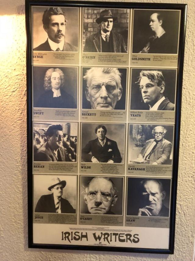
Did we mention the importance of Irish writers to be found in restaurants, bars, hotels? In a lovely Irish restaurant at our last stop, the town of Kilkenny, southwest of Dublin, we saw this poster.
Some Famous Irish Writers
Here are some of the beautiful Irish throws, blankets, scarves and Irish music CDs that we brought back home in the extra suitcase we had to buy!

Beautiful Irish textiles
Many thanks to Tom and Susan for sharing the highlights of their Scotland/Ireland trip!

Monday, November 18, 2013

SKARA BRAE, a Prehistoric Stone Age Village in Scotland's Orkney Islands


The ruins of Skara Brae face the Bay of Skaill
On a windswept island at the northern tip of Scotland, thick, stone walls lie half buried by the edge of the sea.  They are the remains of Skara Brae, one of Europe's oldest known and best preserved prehistoric villages.  Five thousand years ago ancient farmers tended livestock and tilled the earth on land surrounding the village.  They also hunted wildlife and fished along the coast.  Their houses, built of sturdy stone, were clustered in a compact unit and joined along an inner passageway.  They were the heart of a close-knit agricultural community and may have been home to as many as twenty families at one time.
    Art and I visited Skara Brae in the Orkney Islands in late August 1992 as part of the celebration of our twenty-fifth wedding anniversary.  We rode a train north from Edinburgh to John O’Groats and took a ferry from there to the islands.  It was an amazing trip back in time as we viewed the remains of the village where people had lived for nearly 600 years. After they left, wind blew sand from the surrounding dunes over the village and buried it.  For thousands of years Skara Brae was forgotten.

Skara Brae and the manor house of the Laird of Skaill
The weather in the Orkneys is often wet and windy and during our visit we experienced both sun and rain. In the winter of 1850, a series of violent storms battered the islands, pounding them with fierce waves and gale force winds.  One of these storms was so severe that it blew away the grass and sand from a high dune on land owned by William Watt, the Laird of Skaill.  (Laird is the Scottish word for lord.)  When the storm subsided, William Watt went out to inspect the damage to his property.  As he crossed the land that separated his fields from the sea, he saw that the wind and waves had exposed the remains of a long buried ancient village.  For the first time in more than forty centuries, the dwellings of Skara Brae were exposed to the open air.  As William Watt uncovered the ruins he discovered more stone walls, furniture, stone and bone tools, pottery, beads and other objects.  The sand and surrounding embankment had protected the houses and the items in them so well that many were in almost perfect condition.

Today, visitors to Skara Brae can explore the remains of the village and see many of the ancient objects found during its excavation.  No other place in northern Europe provides such a complete picture of life in the neolithic, or new stone age.
Shallow basins in the floor may have held fish bait or a supply of fresh water.
The village of Skara Brae is a cluster of one room houses joined by covered passages.  Today these buildings are open to the sky, but in ancient times they would have been covered by low roofs.  The houses probably had rafters made of whalebone or wood which were then covered with sod and held down by ropes. (Fragments of rope made from twisted heather have been found in the midden.) 
    Of all the ancient sites in the Orkneys, Skara Brae is among the most remarkable.  As we peered over the village walls, it was not hard to imagine families sitting around their hearths long ago talking and eating while children played and neighbors came to visit.  With firelight dancing across the walls and winter winds roaring outside, these sturdy stone houses would have been a welcome retreat from the weather and places where people could feel safe and secure.
The standing stones of the Ring of Brodgar are about six miles from Skara Brae.  They were erected during the same period that people lived at Skara Brae.
Skara Brae is amazing both because it is so old and because so much has been preserved.  People were living at Skara Brae before the Egyptians built their pyramids, before ancient Americans built their first cities and before the Chinese built the Great Wall.  Skara Brae is a window onto some of our most ancient history.  For those of us with roots in northern Europe, the ruins at Skara Brae provide fascinating clues to how some of our most remote ancestors may have actually lived.

You can read more about Skara Brae and the Orkney Islands in my book Stone Age Farmers Beside the Sea (Clarion, 1997).  It is out of print but available online and in libraries.  Or, you can download it to your Kindle.

Update July 21, 2014:  For information about the most recent neolithic discoveries in the Orkneys, check out the August 2014 issue of National Geographic magazine. 

Monday, April 15, 2013

Edinburgh and Dunkeld, Scotland: Castles, Georgian homes, and Macbeth

Entrance to Edinburgh Castle, Scotland
(This is an excerpt from my diary of our London trip in the fall of 1998 when we did a short trip to Edinburgh, Scotland.)

On Thursday morning we took the train to Edinburgh.  The five-hour trip is a pleasant ride through the English countryside and, in Scotland, along the coast facing the North Sea.  Art had been invited to give a talk at the Roslyn Institute (the place where Dolly the cloned sheep was produced) and I went along for the ride.  Art gave his talk on Thursday afternoon and I took advantage of the beautiful sunny weather to visit the Edinburgh Castle.  The castle, which sits on top of a huge rock outcrop and dominates the landscape, was the heart of the original medieval city.  It is still a military post and continues the tradition of firing a cannon at 1:00 each day so people can set their watches. 

View of Edinburgh from Castle
On Friday I met a friend for lunch and a visit to a restored Georgian house on Charlotte Square.  (It was good that we had indoor activities planned for Friday because the weather was rainy and cold, making me glad that I had purchased a hat and tartan wool scarf the day before.)  Edinburgh, which apparently was once known as the Athens of the North, had a burst of development in the early 19th century when many wealthy people built elegant homes there.  I didn't realize that many of the homes in Edinburgh were designed by the same architect who had done the houses in Bath (I don't know if it as the father or son.)   The home we visited is now owned by the National Trust and had volunteers in each room to answer questions such as, why were there pockets in the drape just above the pillows on the bed?  For your pocket watch, of course, because if the watch were laid flat it would stop ticking! In the dining room was a double layered gravy dish.  You put hot water in the bottom portion and the gravy in the top, and the hot water keeps the gravy from getting cold. Afterward, we had lunch at a pub in what used to be an elegant bank.

Dunkeld, Scotland
On Saturday morning we rented a car in Edinburgh and drove about an hour and half north to a little town called Birnam by Dunkeld where we had a reservation at a bed and breakfast.  Both Birnam and Dunkeld are nestled in the hills alongside the river Tay, which is your typical Scottish river with cold rushing water and fly fishermen casting for salmon. This is Macbeth country and Birnam is the same Birnam wood mentioned by Shakespeare’s witches who predict that Macbeth shall remain king until “Birnam Wood shall come to Dunsinane.”  (In real life soldiers apparently cut branches of the trees in Birnam wood and carried them as camouflage as they approached the castle at Dunsinane.)  Along the river we saw a giant oak with a sign claiming that it has been there since Shakespeare’s time.

Walk to a lake near Dunkeld


At the tourist information office we picked up a map of various walks from Dunkeld and Birnam and chose one that went through a forest to a small lake, or loch as they say in Scotland.  We were lucky to have a sunny, beautiful day. 

Monday, April 8, 2013

ROOM WITH A VIEW: Two Year Anniversary of The Intrepid Tourist

Isle of Mull (Inner Hebrides, Scotland)--view from the front door of our country hotel, Tiroran House.
Two years ago, I launched The Intrepid Tourist as an outlet for my accumulated writing and ongoing thoughts from a lifetime of travel.  I didn't know if anyone else would be interested in my posts, but, somewhat to my surprise, the blog has logged more than 28,000 views since it began in April 2011.  Thanks to all of you have been reading my posts!  For this second anniversary I would like to share a few views from my hotel rooms as I have traveled to various places.  I almost always take a photo of the view from my room, both as a document of where I've been, and a reminder that the travel experience is not just the official sights, but also the more personal view.
View of the Dubai skyline with the Burj Khalifa, the tallest building in the world, seen from our hotel near the airport.
In the old days of film cameras, the room views were a way of starting off or finishing a roll of film.  Now, with a digital camera, the view from the room just becomes part of the overall photo album.  Sometimes the view is a spectacular vista, in other cases it may be a glimpse of local life, an unusual perspective, or a momentary event.

On my recent trip to Turkey, my hotel was on a narrow residential street. Each morning as light began to dawn, I was awakened by the call to prayer at the nearby mosque. Later, as I leaned over the small balcony on my third floor street-side room I could see my neighbors, the ubiquitous cats, and the view of the harbor beyond the end of the street. 

View toward the water down Kumbaraci Street, in the Beyglu neighborhood of Istanbul
Occasionally the most interesting view is aerial, sometimes looking down onto an interior courtyard.  On a trip to Barcelona several years ago we stayed in a large, high-rise hotel.  As we looked down into the atrium the umbrellas in the bar area loomed like giant mushrooms.

Looking down onto the bar area of Hotel Rey Juan Carlos in Barcelona.
Sometimes the most interesting view is at night. When I visited Chicago a year ago and looked out of my room one evening, I was struck by the geometric shapes of the buildings framed against the misty night sky.

Night view of Chicago skyscrapers from my room at Hotel 71.
I look forward to more travel in the future and to adding to my photo collection of rooms with a view.  I will continue posting reports and hope that you will continue reading them.  My list of places to go and things to see keeps growing!