Showing posts with label Cornwall. Show all posts

Monday, February 1, 2021

WALKING THE CORNWALL COAST: Part I, by Caroline Arnold at The Intrepid Tourist

Week 5: 52 Places to Go

Cornwall Coast: View of Tintagel from End of Rocky Valley

A Week of Fresh Air and Ancient History (September 1998)

The slate cliffs of the Cornwall coast stretched for miles to the north and south, while the sparkling waves of the Atlantic Ocean disappeared beyond the western horizon. As I peered over the cliff edge into the rocky cove below it was easy to imagine pirates or smugglers stowing their booty in a secluded sea cave. Long ago I had fallen in love with this rugged southwest corner of England as I watched the adventures of Poldark on television and read Daphne du Maurier’s Rebecca. Now I was here and ready to embark with a friend on my first walking holiday.

I had often thought that a walking trip sounded like the perfect combination of exercise and scenery, and Cornwall seemed like the ideal place to start. Not only is its jagged coast spectacularly beautiful, but it has a proud and ancient heritage dating from Neolithic times. From mysterious stone circles in south Cornwall to the reputed birthplace of King Arthur at Tintagel, the walk promised intriguing peeks into history as well as abundant opportunities to enjoy nature.

The Southwest Coast Path

The Southwest Coast Path is a public hiking trail that runs continuously along the coasts of Cornwall and Devon for more than 500 miles. It is well marked and we quickly learned to look for the acorn signposts to point us in the right direction. The portions of the Coast Path that we hiked, between Newquay and Tintagel and near Penzance, were selected both because they promised good views and because there were villages at suitable intervals where we could stay each night. (We booked rooms ahead of time.) We planned our trip for September with the idea that we would miss the summer tourist crowds and still have a chance for good weather. As it turned out, we never had a drop of rain, and although I had packed warm clothes, I didn’t need them. Cornwall does have the mildest climate in all of Britain and likes to think of itself as the English Riviera.

Setting Off
Promenade in Newquay

We spent our first night in Penzance, and then took a bus to Newquay, where gracious old hotels look over a wide beach popular with surfers. As we stepped off the bus we nearly collided with a whiskered gentleman carrying a bell and wearing a tricornered hat, embroidered coat, and knee breeches. At first we thought we had somehow landed in the wrong century, but discovered that he was the official Town Crier. He struck up a conversation and when we told him that we planned to walk nine miles that day, he seemed dubious that we would make it at all. I suppose that we did look like an unlikely pair—two middle-aged women weighed down with heavy packs. He didn’t know that we both had been taking long walks to get in shape. When we told him our plans to walk north, he insisted that we were making a big mistake because, in his view, all the best scenery was to the south!

To Porthcothan
Just outside of Newquay we picked up the Coast Path and began our walk northward toward Porthcothan. In general, the path was level except when it dipped down to a beach and we had to walk across sand. Some of the ascents to the headlands were steep, but we just stopped frequently to admire the view, take a photo, and catch our breath.
Porthcothan

Much of the Coast Path hugs the top of the cliffs and was originally used by customs officers patrolling the beaches for smugglers. As we walked along, we looked down on seagulls, seals, and the occasional shipwreck. The Cornish coast is famous for its treacherous waters, and its rocky shores have claimed countless vessels. On the landward side of the path we looked inland over the green and gold patchwork of the Cornish countryside. Most of the landscape is open and grassy due to the more or less constant wind, but tucked against walls and in protected areas we also saw purple and yellow wildflowers, scarlet rose hips and ripening blackberries. People have been farming in Cornwall since the first settlers arrived from Europe about 5000 years ago. Today's farmers are encouraged to use traditional methods, so the farmsteads, with their sagging slate-roofed houses and enclosed fields, appear much as they have for hundreds of years. Ancient walls keep most animals in their cliff top pastures, but we passed a few sheep grazing perilously on the seaward side.

Ancient Traditions
Cottage window, Mousehole

Celtic people came to Cornwall about 700 B.C.E., bringing with them the knowledge of iron making and Celtic traditions and language. “Cornwall” may come from the Cornish word “Cornovii” meaning “cliff castles.” In our walk we passed numerous Iron Age cliff castles and burial mounds, although to our inexperienced eyes, they usually looked more like grass covered lumps than ancient ruins.

Cornish, a language which is more like Welsh than English, was spoken in Cornwall until 250 years ago. It remains in place names such as Truro, the county seat of Cornwall, Delabole, which boasts Europe’s largest open slate quarry, and Penzance, the town made famous by composers Gilbert and Sullivan's Pirates of Penzance.

Shortcuts
Sharing the Path!

Occasionally we took alternate paths away from the cliff edge. Theoretically these were shortcuts, but were never marked as clearly as the Coast Path and usually required negotiating various stiles and crossing farmer’s fields. On one occasion we had a standoff with a herd of young steers but managed to get through with just being stared at.
We were not purists about walking every inch of the way or carrying our packs when it wasn’t necessary. After the first two days we were able to leave our packs at our hotel (or have them sent ahead by taxi) and then just used a small day pack for our raincoats (which we never needed) and our water and lunch. Even the tiniest villages had little cafes where we could stop for a cup of tea so we didn’t have to carry much food.

Cornish Pasties and Cream Teas
Exercise always guarantees a good appetite and for lunch we usually ate Cornish pasties, the hearty meat-filled pies that originated as a portable lunch for the local tin miners. Although the pasty—rhymes with “nasty”-- has become a fast-food staple in much of England, the best ones are still found in Cornwall. My hiking companion is of Cornish ancestry and told me that the thick dough enabled the pasty to be tossed down a mineshaft unharmed! The other food for which Cornwall is famous is clotted cream, a thick buttery spread that one slathers on fresh scones along with a dollop of strawberry jam.

Part II  (posted on 5/3/11) covers stops in Padstow, Port Isaac, Tintagel, and walks near Penzance.
Go to the end of Part II for information on getting to Cornwall, accommodations, and other details.

For more about traveling in Cornwall, see Gwen Dandridge's post CORNWALL, ENGLAND: Long Lost Kings, Mermaids, Pirates and Cream Teas, Guest Post by Gwen Dandridge.

All text and photos copyright Caroline Arnold.

Monday, April 28, 2014

CORNWALL, ENGLAND: Long Lost Kings, Mermaids, Pirates and Cream Teas, Guest Post by Gwen Dandridge


Zennor, Cornwall
My friend Gwen Dandridge and her husband recently returned from a trip to Cornwall and sent me this post.  Gwen has many talents ranging from fantasy writing to gardening to Morris dancing.  She is the author of The Stone Lions which received the Gold Seal of Excellence from Awesome Indies. You can find out more about her at her blog. Here is her post:
 
Last month my husband and I roamed the farthest southwestern edge of England. It was March, a month known for wild and wet weather in a land that is wild and wet.
Celtic Cross at St. Just, Cornwall
We started in Plymouth, Devon to hear golden-throated Mary Black and the Irish musicians/song writers, Clannad. That evening wrapped us in the magic of England’s southern lands giving us a proper welcome.

Gwen at Dartmoor
From there we headed to Dartmoor, climbed some tors and listened through the howling winds for the hounds of Baskerville. We didn’t hear any but nevertheless enjoyed the climb in the wind and rain to view the distant green fields.

Tintagel, legendary home of King Arthur
A short drive later, a drive on the left side of narrow hedged roads, we arrived at Tintagel, possible castle home of the legendary King Arthur. While its history waxes and wanes between fact and lore, certainly it was the remains of a fortification from the Roman-British era, and further developed during the 1100’s--Arthur’s time. In the 1200’s a rich Earl, enamored by the Arthur story, remade Tintagel into a seat of power. 

Whoever inhabited Tintagel, they picked well. The fortress sits on a prime promontory to defend the harbor. No ships or army can approach unseen. The site also feeds the eye as it overlooks the Celtic sea across to Ireland, with views of crashing waves and open skies.
The Eden Project
From there we meandered south, combing the countryside stopping at the Eden Project, working cider mills, forgotten gardens and quaint seaports. Each seaport had it’s charms: St. Mawes,  St. Just, St. Michael Mount, the equivalent of Mont Saint-Michel in Normandy, and Zennor, if you seek mermaids.
Mousehole
The seaside town of Mousehole lived up to its name, a tiny town with a single carriage road leading in and out, overlooking a small harbor. We had a proper cream tea there: tea and scones served with clotted cream and strawberry preserves.

Lizard Head

While the farthest south point on the western edge, Land’s End, is disappointingly touristy, Lizard Head, the south-eastern most point is a jewel worth walking.
Glendurgan Garden and Maze, near Falmouth
If you are so inspired, there is a footpath that goes from one point to the next, sixty-nine miles. A slow leisurely walk in the Cornish countryside surrounded by sea, pasture and moor.

St. Michael's Mount at Low Tide
This may be the perfect way to explore this region, on foot with the sea and sky surrounding you. And perhaps if you watch carefully, you might see a mermaid sunning on the shore.

All text and photos copyright Caroline Arnold.
 

Tuesday, May 3, 2011

Walking the Cornwall Coast: Part I

A Week of Fresh Air and Ancient History (September 1998)
View of Tintagel from End of Rocky Valley
The slate cliffs of the Cornwall coast stretched for miles to the north and south, while the sparkling waves of the Atlantic Ocean disappeared beyond the western horizon. As I peered over the cliff edge into the rocky cove below it was easy to imagine pirates or smugglers stowing their booty in a secluded sea cave. Long ago I had fallen in love with this rugged southwest corner of England as I watched the adventures of Poldark on television and read Daphne du Maurier’s Rebecca. Now I was here and ready to embark with a friend on my first walking holiday.

I had often thought that a walking trip sounded like the perfect combination of exercise and scenery, and Cornwall seemed like the ideal place to start. Not only is its jagged coast spectacularly beautiful, but it has a proud and ancient heritage dating from Neolithic times. From mysterious stone circles in south Cornwall to the reputed birthplace of King Arthur at Tintagel, the walk promised intriguing peeks into history as well as abundant opportunities to enjoy nature.

The Southwest Coast Path
The Southwest Coast Path is a public hiking trail that runs continuously along the coasts of Cornwall and Devon for more than 500 miles. It is well marked and we quickly learned to look for the acorn signposts to point us in the right direction. The portions of the Coast Path that we hiked, between Newquay and Tintagel and near Penzance, were selected both because they promised good views and because there were villages at suitable intervals where we could stay each night. (We booked rooms ahead of time.) We planned our trip for September with the idea that we would miss the summer tourist crowds and still have a chance for good weather. As it turned out, we never had a drop of rain, and although I had packed warm clothes, I didn’t need them. Cornwall does have the mildest climate in all of Britain and likes to think of itself as the English Riviera.

Setting Off
Promenade in Newquay

We spent our first night in Penzance, and then took a bus to Newquay, where gracious old hotels look over a wide beach popular with surfers. As we stepped off the bus we nearly collided with a whiskered gentleman carrying a bell and wearing a tricornered hat, embroidered coat, and knee breeches. At first we thought we had somehow landed in the wrong century, but discovered that he was the official Town Crier. He struck up a conversation and when we told him that we planned to walk nine miles that day, he seemed dubious that we would make it at all. I suppose that we did look like an unlikely pair—two middle-aged women weighed down with heavy packs. He didn’t know that we both had been taking long walks to get in shape. When we told him our plans to walk north, he insisted that we were making a big mistake because, in his view, all the best scenery was to the south!

To Porthcothan
Just outside of Newquay we picked up the Coast Path and began our walk northward toward Porthcothan. In general, the path was level except when it dipped down to a beach and we had to walk across sand. Some of the ascents to the headlands were steep, but we just stopped frequently to admire the view, take a photo, and catch our breath.
Porthcothan

Much of the Coast Path hugs the top of the cliffs and was originally used by customs officers patrolling the beaches for smugglers. As we walked along, we looked down on seagulls, seals, and the occasional shipwreck. The Cornish coast is famous for its treacherous waters, and its rocky shores have claimed countless vessels. On the landward side of the path we looked inland over the green and gold patchwork of the Cornish countryside. Most of the landscape is open and grassy due to the more or less constant wind, but tucked against walls and in protected areas we also saw purple and yellow wildflowers, scarlet rose hips and ripening blackberries. People have been farming in Cornwall since the first settlers arrived from Europe about 5000 years ago. Today's farmers are encouraged to use traditional methods, so the farmsteads, with their sagging slate-roofed houses and enclosed fields, appear much as they have for hundreds of years. Ancient walls keep most animals in their cliff top pastures, but we occasionally passed a sheep grazing perilously on the seaward side.

Ancient Traditions
Cottage window, Mousehole

Celtic people came to Cornwall about 700 B.C., bringing with them the knowledge of iron making and Celtic traditions and language. “Cornwall” may come from the Cornish word “Cornovii” meaning “cliff castles.” In our walk we passed numerous Iron Age cliff castles and burial mounds, although to our inexperienced eyes, they usually looked more like grass covered lumps than ancient ruins.

Cornish, a language which is more like Welsh than English, was spoken in Cornwall until 250 years ago. It remains in place names such as Truro, the county seat of Cornwall, Delabole, which boasts Europe’s largest open slate quarry, and Penzance, the town made famous by composers Gilbert and Sullivan's Pirates of Penzance.

Shortcuts
Sharing the Path!

Occasionally we took alternate paths away from the cliff edge. Theoretically these were shortcuts, but were never marked as clearly as the Coast Path and usually required negotiating various stiles and crossing farmer’s fields. On one occasion we had a standoff with a herd of young steers but managed to get through with just being stared at.
We were not purists about walking every inch of the way or carrying our packs when it wasn’t necessary. After the first two days we were able to leave our packs at our hotel (or have them sent ahead by taxi) and then just used a small day pack for our raincoats (which we never needed) and our water and lunch. Even the tiniest villages had little cafes where we could stop for a cup of tea so we didn’t have to carry much food.

Cornish Pasties and Cream Teas
Exercise always guarantees a good appetite and for lunch we usually ate Cornish pasties, the hearty meat-filled pies that originated as a portable lunch for the local tin miners. Although the pasty—rhymes with “nasty”-- has become a fast-food staple in much of England, the best ones are still found in Cornwall. My hiking companion is of Cornish ancestry and told me that the thick dough enabled the pasty to be tossed down a mineshaft unharmed! The other food for which Cornwall is famous is clotted cream, a thick buttery spread that one slathers on fresh scones along with a dollop of strawberry jam.

Part II will cover stops in Padstow, Port Isaac, Tintagel, and walks near Penzance.
Go to the end of Part II for current information on getting to Cornwall, accommodations, and other details.

All text and photos copyright Caroline Arnold.

Walking the Cornwall Coast: Part II

Heading North

Lifeboat Station, Mother Ivey's Bay
Our second night was spent in Padstow, a quaint fishing village tucked into the side of the long estuary of the River Camel. As we walked the narrow cobblestone lanes of the town we discovered Prideaux Place, a small, but elegant, Elizabethan manor house overlooking a deer park. It is open to the public several days a week and has a tea shop.

The following morning we arrived at the harbor to find that the tide was out and that the boats were lying stranded in the sand, looking much like giant, comical insects. We followed the signs to the lower ferry landing to catch our ride across the estuary and then continued our walk northward toward Port Isaac, another historic fishing village. Cornwall’s fishing industry supplies much of Europe with seafood and provided us with many delicious dinners during our trip. Throughout our week in Cornwall we had tasty, freshly prepared food, but our dinner that night at the Port Gaverne Hotel, which included liver pate, a fresh fish platter, and a salad made with bacon and lightly sauteed scallops, was one of the best.

King Arthur (perhaps)
In addition to the natural beauty of the Cornish coast we saw the occasional lighthouse, castle and ancient ruin. The most spectacular ruin is at Tintagel, (pronounced tin TAJ el), where after climbing onto the rocky peninsula we found crenellated castle walls, an old church, an herb garden, and even the remains of a medieval toilet closet built into the castle wall at the edge of the cliff. Apparently the inhabitants hung clothes in the toilet closet because the smell kept out moths and other harmful insects!
Caroline at Tintagel

Tintagel is most famous as the reputed birthplace of King Arthur, although most historians discount any connection between the castle and the real Arthur, a Celtic warrior king who would have lived in the 6th century. The character that most of us know is a literary fiction created first by Geoffrey of Monmouth in the 12th century and popularized by Tennyson in the 19th century. Recently, however, an ancient slate, inscribed with a name that could refer to Arthur, was unearthed at Tintagel. It is the newest of a number of tantalizing clues that suggest there may be some truth to the legend. The real story may never be known, but the island ruins certainly provide a romantic setting for the tale and the village businesses capitalize on the connection. Other sights to see in or near Tintagel include the 11th century church of St. Materiana, the old post office, and Neolithic petroglyphs at Rocky Valley.

Penzance
Our last two nights were spent in Penzance. This town of 20,000 is on the west side of Mount’s Bay and has been a popular tourist destination since Victorian times when the railroad made it easy for people to get there from London. One still half expects ladies in long dresses and parasols to come strolling down the seaside promenade. Among the local attractions is the city park which features palm trees and other tropical plants.

Most visitors to Penzance make the ten-mile journey to Land’s End so they can have their photo taken at England’s most westerly point, but we decided to give Land’s End a miss when we heard that it is crowded and commercialized. Instead, we took a short bus ride to Marazion and walked across the causeway to St. Michael’s Mount, a tiny castle-topped island in the middle of the bay. The castle, originally built in the 12th century as a Benedictine Priory, is now owned by the St. Aubyn family. It is open to the public and provides breathtaking views across the water. We returned by boat because by afternoon, the tide had submerged the causeway.
Mousehole Harbor at Low Tide

The next day we walked from Penzance around the other side of the bay through Mousehole to Lamorna, one of the many artists’ colonies in Cornwall. Artists have long been attracted to Cornwall both because of its natural beauty and the brilliant light. Their work can be seen at numerous galleries and museums, including the Newlyn Art Gallery near Penzance and the Tate Gallery in St. Ives.

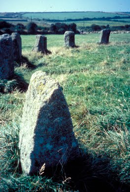
The Merry Maidens (Stone Circle at Lamorna)

The trip to Lamorna also included a visit to the Merry Maidens, a 4000-year-old stone circle, said to be young girls turned to stone because they were caught dancing on Sunday. In three adjacent fields, single standing stones are supposed to be the pipers who led them astray. South Cornwall has numerous Stone Age sites including other stone circles, as well as many burial chambers, holed stones, and quoits, or table stones.


A Cornish Mile
An overview of Cornwall’s long history can be seen at the beautiful Penlee House Museum in Penzance. There I read about a gentleman who visited Cornwall in 1602 and noted that it seemed as if “Cornish miles are much longer than those about London.” (They may have been, since distances had not yet been standardized.) I wondered if he had done a walking trip! There were a few times during our trip that I felt the distances seemed longer than those indicated on our maps, but perhaps that was because I stopped so often to admire the view. Every turn revealed a new perspective--a distant lighthouse, a natural stone archway, a hovering kestrel, or perhaps an abandoned flower field from the days when Cornwall provided London markets with early spring blooms. In our six days in Cornwall we saw a lot, but we still have a long list of things to do on another trip. Perhaps, next time we’ll head south as the Town Crier suggested.


Practical Considerations
(Although I walked the Cornwall Coast Path more than ten years ago, it is much the same today.  The following information is current.)
Getting there: There are several trains a day from Paddington Station in London to Penzance; from Heathrow, take a bus to Reading and catch the train from there. Train information in London is at 0345 484950. If you drive, take the A30 all the way from London to Penzance. Penzance is 280 miles southwest of London.
Getting around: Buses run frequently between most towns although less often on weekends. Taxis are also available.
Where to stay: Guides to bed and breakfasts in Britain are available from most large bookstores in the U.S. and from the AAA. Tourist Information Centers (TIC), located in most larger towns, can help you arrange accommodation. The TIC phone in Penzance is at 01736 362 207. In summer and holiday periods reservations are a must.
Hiking the Coast Path: I bought maps and guidebooks in London at a store called Stanfords at 12-14 Longacre Street WC2, but you can also find what you need at bookshops or outdoor suppliers in the larger towns of Cornwall. The South West Coast Path Association publishes a guidebook, see website below. (Some portions of the Coast Path are owned by the National Trust.) For short walks you can usually get maps and directions at your hotel or local TIC.

For a MAP and information on the SOUTH WEST COAST PATH go to http://www.southwestcoastpath.com/

Monday, April 25, 2011

A Scilly Holiday, Seriously: Part II

(A continuation of my previous blog.)
Harbor at St. Mary's
Low Key Entertainment
Most entertainment on the Scillies is home-grown. It includes musical performances by the local choral society, family quiz night at the local pub--a sort of do-it-yourself Jeopardy game with prizes awarded at the end of the evening to the table that answers the most questions correctly–as well as slide shows and boat races. One evening we went to a shipwreck slide show at the Methodist Church hall where we sat on folding chairs and were regaled with witty stories of ships that have gone afoul in Scilly waters. The program featured the 1998 wreck of the German container ship, the Cita, whose captain had apparently gone to sleep at the wheel, only to wake up and find his ship stuck on a reef. The ship quickly broke up, littering the shore of St. Mary’s for weeks with designer shirts, baby clothes and sneakers (or trainers as they call them in Britain), tires, Toyota parts, plastic Irish fridge magnets and more. Photos and samples are on display in the museum.

Ships traveling through the Scilly Isles usually depend on local pilots to guide them safely through the channel or to bring them into harbor. In the nineteenth century, pilots competed to guide ships through the area. As soon as a ship was spotted, each pilot and his six man rowing crew jumped into their wooden boat, or gig, and raced out to meet it. The first to arrive got the job and the fee, so the pilots with the strongest, fastest crews were the most successful. Today, piloting is mechanized, but gig racing has become a professional sport, with races held throughout the summer. On the Friday evening we were there, it seemed as if the entire population of St. Mary’s had assembled on the quay to cheer on their favorite team. We watched from the opposite shore, in the garden of Juliet’s restaurant, using our binoculars to spot the boats as they approached the finish line. Later we enjoyed a spectacular sunset.

Playing Golf on St. Mary's
One day we played golf, primarily to enjoy the beautiful location of the golf course. Perched high on the moor, it provides views of the islands all the way to the Bishop Rock Lighthouse, Britain’s most westerly beacon, and the marker for the entrance to the English Channel. Our main challenge was keeping the ball on the fairway and not in the surrounding rocks, bracken, heather, or cow pasture. As it happened, we were almost alone on the course. The Scillies are sufficiently north to provide long summer days, and with twilight lingering late into the evening, one can begin a round of golf as late as 5:00 in the afternoon. We, however, started in the morning, and stopped halfway through for lunch at the clubhouse, where I ordered a sausage bap. Baps (buns) and other delicious fresh bread are available daily from a bakery on St. Mary’s. Another favorite lunch was Cornish pasties, the meat filled pies typical of the region, available at the butcher shop.

Cornish Cream Teas, Pasties and More
During the summer tourist season accommodations fill up quickly; most bed and breakfast establishments will only take a reservation for a week at a time. (Hotels book on a daily basis, but are more expensive.) We felt lucky to get a reservation at Eastbank–probably because it hasn’t yet been discovered. The owners were welcoming and provided us with more than enough breakfast food, which we served ourselves in a separate kitchen/living room that we shared with two other guests. They also gave us advice on restaurants and warned us that we should make dinner reservations a day or more in advance unless we wanted to eat at one of the pubs, which don’t require reservations, but where the food is typically English–hearty and served with lots of fries. The top of their restaurant list, and our favorite, was Chez Michel, housed in a tiny stone cottage in Hugh Town and specializing in Continental style food. On our first visit we arrived at a particularly chaotic moment and the waitress joked that we had come to Fawlty Towers, but after a glass of sherry, things settled down and we enjoyed a delicious meal. That night we ordered noisettes of lamb--tender pieces of meat served with a rich brown sauce and spinach souffle; another night we had duck with cranberries and fresh garden vegetables.

The best foods in the Scillies are the local specialties. Fish is always fresh and in summer so are the local vegetables. Tomatoes were in season and we enjoyed them on sandwiches, in salads and soups, and roasted. On several afternoons we treated ourselves to a Cornish cream tea. Small scones are served warm with fresh clotted cream, a heavenly product halfway between butter and whipped cream, and strawberry jam. With a cup of hot English tea, it is the perfect afternoon pick-me-up.


Bulbs and Produce for sale at side of road

Fresh Spring Flowers
Popular souvenirs from the Scillies are the locally grown flower bulbs. The mild climate of the Scillies makes it ideal for growing daffodils and other flowers, which mature earlier in the season than elsewhere in the British Isles, giving the Scilly growers a jump start on the market each spring. Fall is planting season, and we saw huge sacks in the fields, full of bulbs waiting to be put in the ground. I wished I could bring some bulbs home but knew that we would never get them past U.S. customs officers. Instead we bought some scenic watercolor prints at the Nan Heath gallery, one of the several art and craft studios on the islands. Watercolor is the ideal medium for capturing the brilliant light and clear waters that bathe the Scillies, and the deftly painted pictures will continue to remind us of some of our favorite spots.

Locked in Time
Although the Scilly Isles are a popular holiday spot for Brits and some French vacationers who sail across the channel in their private yachts, they off the radar screen for most Americans. During our week in the islands we encountered only one other American, a woman we met on the path in front of the Abbey Gardens on Tresco. She had flown over for the afternoon from the mainland and stopped us to ask if we knew where she could go shopping! We had to tell her that besides the garden gift shop, there was no place to shop on Tresco. If she had come for a longer visit she would have found a number of souvenir shops along the main street in Hugh Town on St. Mary’s.

Even though tourism is now the primary industry in the Scillies, the local residents are working hard to prevent the kind of large scale development and commercialism that would ruin the small town and rural charm of the islands. We were told that building permits are impossible to get except to replace an already existing building. And since most buildings are constructed of sturdy stone and old enough to be protected as historical structures, the town hasn’t changed much since the end of the last century. Our bed and breakfast was unusual in that it was entirely new construction. The owners had been able to build a new house only because the previous one had been filled with asbestos and had to be destroyed. We were among their first season’s guests.

Back to the Mainland
Flying Back to Land's End
Ferry service from Penzance to St. Mary’s runs Monday through Saturday, leaving in the morning and returning in the afternoon. (Sunday is a blessedly quiet day with no air or ferry service, and therefore no influx of day trippers. ) For our return trip to the mainland we took a small plane so that we would get there early enough to catch the train that day back to London. When we arrived at the tiny airport, we not only had to weigh our luggage, but step on the scales ourselves! We realized as we climbed into the plane behind the pilot that every pound had to be accounted for in arranging passengers and luggage in our ten seat fixed wing aircraft. As we roared down the short runway toward the ocean it seemed as if we would plunge into the sea, but as we crested the hill the plane lifted into the air. Ten minutes later we touched down at Land’s End in Cornwall, where a bus was waiting to take us into Penzance and the train station.

Before our trip to the Scillies we had been advised to get travel insurance on the off chance that the boat or plane might be cancelled. Storms and fog have been known to cut off the Scillies from the mainland for days, although usually not in summer. We never needed the insurance and had the good luck to enjoy a week of perfect weather–not too hot or cold and no wind or rain. We had chosen the Scilly Isles as the place for our summer holiday without knowing much about it. Now that we’ve been there, we can see why people go back again and again.

Our trip to the Isles of Scilly was in August 2003.
Click here for current MAPS and TOURIST INFORMATION.