Monday, September 28, 2020

POINT REYES NATIONAL SEASHORE, California: McClure’s Beach

McClure's Beach, Point Reyes National Seashore, California
In mid-August Art and I spent a day at Point Reyes National Seashore and I wrote the report below. A week later, wildfires broke out all around the greater Bay Area, including the Woodward fire in the southern part of the National Seashore. If you are planning a trip to the area, be sure to check the National Park website to find out which areas may be closed.

For a change of scenery from our house in Oakland we did an expedition last week to Point Reyes National Seashore in Marin County and hiked down to McClure's beach, the northernmost beach on the Pacific side of the long peninsula. It was the perfect Covid destination, with so much room for social distancing that we could barely see the few other people who were there. (We did our trip on a weekday–which also helped reduce the number of people.) It was also the perfect choice temperature-wise on a warm summer day--not too cold and not too hot.
Near the end of the trail to McClure's Beach.
It had been a long time since we've been to Point Reyes, and my memory is that it can be windy and cold, and that is certainly true in winter. It can also be enshrouded in fog. But we were lucky and visited on a warm August day, perfect for a picnic and walk on the beach.

Point Reyes is a long peninsula, about an hour’s drive north of the San Francisco Bay area. The west side faces the Pacific Ocean, where heavy surf pounds the shore underneath steep cliffs. The east side faces much calmer Tomales Bay, a narrow strip of water dividing Point Reyes from the mainland. The south facing part of the peninsula is on Drake’s Bay, named after the English explorer Sir Francis Drake, who is believed to have landed there on his trip around the world in 1579.
Pierce Point Ranch with Tomales Bay to the East
We drove from Oakland across the Richmond Bridge to San Rafael and then through beautiful rural Marin County. At first the landscape is rolling farmland, but then the road passes through stands of gorgeous redwoods before emerging near the coast. We entered Point Reyes National Seashore just south of the town of Point Reyes Station, driving along Francis Drake Boulevard. After passing  through the small town of Inverness, we came to a choice point–left, the road to the lighthouse (now partially closed), or right to the northern beaches and Historic Pierce Point Ranch.
Historical marker at Pierce Point Ranch. The ranch was established in the 1820s by James Berry, a Mexican citizen, who lost it in a land dispute after California became a state. In 1858, the land was sold to the Pierce family.
We went to the right, drove to the end of the road and parked in the shade of giant eucalyptus trees planted by early settlers. There we had another choice point–a hiking trail to McClure’s beach, or another trail along the top of the ridge to the end of the peninsula. We chose the former, a .4 mile path that follows a narrow stream to the bottom of the cliff and the wide expanse of the beach.
Trail to the beach is .4 miles down a sandy path.

At the end of the trail, flowers bloom along the edge of a shallow pond at the base of the cliff.

Walking north on McClure's Beach
After eating our sandwiches in the shade of the cliff, we took a walk along the shore. The tide was out, leaving a band of empty mussel shells, kelp, jelly fish and random feathers along the tide line.
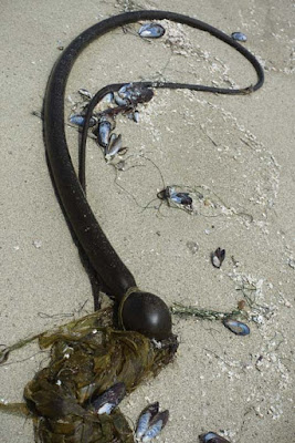
Kelp and mussel shells
Jellyfish
Historically settled by ranchers, the open grasslands of Point Reyes are still used for grazing cattle, although the ranches are now managed by the National Park Service. The northern tip of Point Reyes is a designated refuge for Tule Elk, a native Californian elk, similar to Rocky Mountain elk but smaller, and once in danger of extinction.
The last curve of the road before arriving at Pierce Point Ranch. At the top of the photo, the white spot is Bird Rock, located just off Tomales Point, the extreme northern tip of Point Reyes.
On our way back up the trail we spotted a herd of elk grazing on a hillside near the road. As we drove out we stopped to get a closer look and take a picture of the elk, but they were too far away. After we got home I realized that a tiny spot in one of my pictures was actually an elk.

There are many options for hikes at Point Reyes. We plan to go back in the future and try some of the other trails.

Map: Click HERE for a map of Point Reyes.

Note: The Point Reyes visitor centers are currently closed, as are some of the trails and roads. Be sure to consult the Point Reyes National Park website for current information.
As of September 23, the area and all trails south of Limantour Road and Bear Valley Road, west of Highway 1 (aka Shoreline Highway), and north of Stewart Trail are closed to all visitor access until further notice.

Monday, September 21, 2020

16 DAYS IN MOROCCO, Part 2: Guest Post by Tom and Susan Weisner

Fez, Morocco.
Our friends Tom and Susan Weisner went on a tour of Morocco last year and have kindly agreed to share a few of their wonderful photos and memories of the trip. Part 1 posted last week. This is Part 2.
Our guide.
Our trip to Morocco was  part of a group tour organized by Reed College, where Tom was a student in the 1960s. There were 15 in our group, including Paul Silverstein, an anthropologist who teaches at Reed and who does fieldwork in Morocco. We had a great Moroccan guide too!

Fes
Rug merchants, Fes.
Susan dressed up inside a weaving store somewhere in the souk.
Fes is the second largest city in Morocco, 1.4 million, historic cultural center, former capital until 1912. Souk (market) and Medina (old quarter) of Fez is a World Heritage site –a huge, endless twisting world inside!
Want some rugs, slippers, shoes, jewelry, DATES, weaving and cloth - or about any other thing you could think of? It’s in some alley somewhere. But just  try and find your way back out!

Berber Villages (Meknes-Tafilalet)
Our group had lunch in a Berber village.
Two friends in our small tour group playing dress-up inside the Berber village.
Paul Silverstein, Reed anthropologist, did field research in this Berber area in the South near the Atlas Mountains. This led to side events such as Paul taking Tom to meet Moroccan informants of his, journalists, etc. He took our group into enclosed walled villages (Meknes-Tafilalet) and we had lunch inside – tea in a field basically. Awesome. There was a small “museum" inside as well.

 Ouarzazate
Ouarzazate, nicknamed the "door of the desert"
Our “rock” hotel was like a fort!
Ouarzazate is a historic city in the Southern Berber area in Morocco, in the High Atlas Mountains. Gateway to the Sahara desert to the South. Famous “Kasbah” there. It was also turned into a location site for making movies with an exotic, middle east/desert setting (Gladiator; Game of Thrones, etc.).
Ksar of Ait-Ben-Haddou outside Ouarzazate in the walled Berber communities of the South of Morocco.
Then driving over the Atlas Mountains – steep, curvy. Susan loved it. (Not really.)

Marrakech
Marrakech market square
The VAST main market square famous in Marrakech; we spent several hours there. There is a huge souk (bazaar or marketplace) surrounding it.
Susan bought some green plates here.
Susan and Tom with camel.
Yes; there are camels but this is just at a tourist rest stop where you could take a picture with one. We never got near any actual desert oasis with camels. There are stray cats EVERYWHERE.
We all got various stomach problems in Morocco. There was a Burger King near our hotel in Marrakech. An exotic one, of course, but just what we needed. We got dinner there. Mmmmmmm.

Essaouira
Essaouira is on the Atlantic coast of Morocco. It is a beautiful city – historic French and colonial. 
One of the many shops in the Essaouira medina. (Medina is an old Arab word for the non-European part of a North African city.)
Viagra for men and women available in the Medina..
Susan sees a totally torn up violin in a case at a museum in Essaouira.
And yes, there are goats that climb in the trees and eat stuff along the roads….
 For Part 1 of 16 DAYS IN MOROCCO, see the post for 9/14/20..

Monday, September 14, 2020

16 DAYS IN MOROCCO, Part 1: Guest Post by Tom and Susan Weisner

Chechaouen, "The Blue City", Morocco
Our friends Tom and Susan Weisner went on a 16 day tour of Morocco in June 2019 and have kindly agreed to share a few of their wonderful photos and memories of the trip. This is Part 1. Part 2 will post next week.

Our trip to Morocco was part of a group tour organized by Reed College, where Tom was a student in the 1960s. There were fifteen in our group, including Paul Silverstein, an anthropologist who teaches at Reed and who does fieldwork in Morocco. We had a great Moroccan guide too!

Rabat, Capital of Morocco
Palace near Rabat.
Morocco is a kingdom with some parliamentary government. This is the palace near Rabat. There are other palaces as well.
Rabat fort and inner city at night.
The tomb of Mohammad VI (former king) is in Rabat. Rabat has a huge market in old city walls with narrow streets.

Casablanca, the largest city in Morocco
Susan and Tom at the mosque in Casablanca.
King Hassan II built the second largest mosque in the world in Casablanca (Mecca is #1). It is marble, vast, on the Atlantic coast. Non-Muslims can only enter as part of an official tour.
Typical Moroccan dish.
A beautiful restaurant.
We enjoyed wonderful food! Tajines! (Tajine dishes are slow-cooked savory stews, typically made with sliced meat, poultry or fish together with vegetables or fruit.)
Synagogue
Hundreds of thousands of Jews once lived in Morocco, but most left during and after WWII, going to Israel, Europe and elsewhere. Morocco does not recognize Israel, but the Israeli passport is recognized since so many from the diaspora do sometimes return. We saw a number of museums and synagogues that are protected. Morocco is about the only Muslim Middle East country that has religious pluralism in the constitution.
Catholic church in Casablanca
There are thousands of black sub-Saharan African immigrants arriving in Morocco, trying to get to Europe. Many are Christian. This is a Catholic Church in Casablanca for them. A very rare sight.

Romans in Morocco: Volubilis, Ancient Roman City near Meknes
Roman ruin with mosaic floor.
The Romans, of course, settled all of North Africa including Morocco. We visited Volubilis near the city of Meknes, for example, an entire former Roman city with over 40K inhabitants.Volubilis is a World Heritage site.
Ancient Roman Empire included northern portions of Morocco.
Morocco is in the lower left corner of this map in red.

Tangiers
American National Historic Landmark in Tangiers.
A landmark to the American legation is inside the Medina, or interior market in Tangiers. It was the first American government office outside the US. It is also the site of a Paul Bowles museum.
View of Tangiers
Morocco gained independence from France in 1956 and Rabat became the new capital. replacing Tangiers as the capital city. You can see Tangiers city in white in the distance from our beautiful hotel on the Mediterranean. Spain is faintly visible on the far horizon just a few miles away across the Strait of Gibralter.

Chechaouen
Chefchaouen is a city in Morocco that's famous for its blue hue. While it was founded in 1471, it didn't get its distinctive color until 1492, when it received an influx of Jews escaping the Spanish inquisition, who brought a tradition of painting buildings blue.
Chechaouen, the Blue City, is between Tangiers and Meknes.  Beautiful! We saw many stalls and shops as we walked through the narrow alleys everywhere. Lunch and tea there.
Market stall in Chechaouen.
Purses, shoes and more!
Part 2 of 16 DAYS IN MOROCCO will post next week.


Monday, September 7, 2020

TEMESCAL CANYON HIKE: Nature at the Edge of the City, Los Angeles, CA

Trail to waterfall from Temescal Gateway Park, Pacific Palisades, CA
On a recent weekday afternoon, we set off for Pacific Palisades in Los Angeles for a hike in Temescal Gateway Park and from there into Topanga State Park (part of the Santa Monica Mountains.)
A kiosk at the entrance of the park displays a helpful diagram of the park on one side and a map with hiking trails on the other. Temescal Gateway Park encompasses a large grassy area and a wooded complex used as a conference center. (Due to the pandemic, the conference center is closed and few people were around.)
A map provides a guide to several trails that branch off from the park.

After parking in the large lot just off Sunset Boulevard, we followed the road through the conference center to the Temescal Waterfall trail head. (A parallel path follows the creek bed.)

Nasturtiums have gone wild along the shady forest floor.

The park was first developed in the early 20th century and has been preserved as a natural area ever since. The trees are enormous, growing tall to reach the light from the bottom of the canyon. They also provided shade for most of our walk, making this a pleasant excursion on a warm summer day.

Giant pines, oaks, and eucalyptus tower over the path.

Elderberries and other plants along the path. Chapparal covers the upper slopes of the canyon.

After walking along under an archway of ancient trees and  passing a shaded picnic area, the path narrowed and began to climb, opening up to provide a view of the top of the canyon. A variety of summer flowers were in bloom and elderberries were ripening in the sun. A red-tail hawk soared overhead.
The history of Temescal Canyon goes back to the early days of Pacific Palisades.

We were running out of time so stopped just short of the waterfall–which in summer is barely a trickle–and retraced our steps back to the parking lot. Had we continued, we would have crossed a small bridge and returned to the beginning of the trail on the other side of the creek. Next time we’ll start earlier, and do the full loop! Or, perhaps, try one of the other trails into the park.
The branches of a California live oak are thick with age.

For directions and a description of the hiking options in Temescal Canyon click HERE.