Monday, December 28, 2020

BRIONES REGIONAL PARK, LAFAYETTE, CA: Open Space Perfect for a Family Outing, by Caroline Arnold at The Intrepid Tourist

Briones Regional Park, Bear Creek Staging Area, Lafayette, CA

On the Thanksgiving weekend, when we were in Oakland, we enjoyed a family hike and picnic at Briones Regional Park, a large (6,117-acre) open space that is part of the East Bay Regional Park District system. It was a beautiful sunny day, perfect to be outdoors. 

Cottonwood tree, invaded by mistletoe

 Briones Regional Park consists of picnic and play areas as well as trails traversing rolling hills and oak woodlands. From Oakland, we exited the 24 Freeway at Orinda, then drove through a series of hills before turning in at the Bear Creek staging area. We found the parking lots nearly filled but we didn't see very many people. We wore masks and the trails are wide enough that when we did pass other hikers, we could do so at a distance.


Signs at the entrance to the trails inform hikers that the park is a dual use area–both for people and for cattle grazing. In fact, shortly after we began our hike we encountered a cow and her calf at the side of the trail, but they paid little attention to us as we walked by.

Acorn woodpecker in flight.

We followed the mostly level trail to the Maud Whalen fenced picnic area, where we had our lunch. The trees at the edge of the field were full of noisy woodpeckers and we watched them dart out into the air, apparently catching insects, before returning to the trees. High overhead a pair of hawks soared on the updrafts.

Thistles gone to seed.

Two years ago we did a similar hike at Briones in early summer, when wildflowers were in bloom and birds were nesting. On this trip in late fall, the grass had turned golden brown and flowers gone to seed. 

California Buckeye tree.

At several places in the park we noticed bare trees covered with large round fruits, suspended like Christmas balls. Those that had fallen to the ground had cracked open, revealing a nut-like interior. We wondered why wild animals hadn’t eaten them. Then I found out why–they are poisonous. The trees are California buckeyes (Aesculus californica). Native American tribes, including the Pomo, Yokut, and LuiseƱo, used the poisonous nuts and seeds to stupefy schools of fish in small streams to make them easier to catch. The bark, leaves, and fruits contain the neurotoxic glycoside aesculin, which causes hemolysis of red blood cells. Buckeye wood also makes a good fireboard for a bow drill or hand drill. Native groups occasionally used the plant as a food supply; after boiling and leaching the toxin out of the seeds or nut meats for several days, they could be ground into a flour or meal similar to that made from acorns. 

Cattle along the side of the trail.

Our hike was not long--a total of a little over two miles. But it was refreshing to be in the open air and get some exercise at a time when most of us are confined to our homes day after day. 

Thanks to Matt Arnold for the first and fourth photos. 

All text and photos, copyright Caroline Arnold. www.theintrepidtourist.blogspot.com
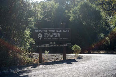
Entrance to Bear Creek Staging Area, Briones Regional Park


Monday, December 21, 2020

HAPPY HOLIDAYS from Caroline Arnold at The Intrepid Tourist

Christmas window display at Alpine Village, Torrance, CA
 

On this shortest day of the year, I send you best wishes for a

HAPPY HOLIDAY SEASON!

Monday, December 14, 2020

ALEXANDER CALDER SCULPTURES at SFMOMA, San Francisco, CA, by Caroline Arnold at The Intrepid Tourist

Fish Bowl by Alexander Calder at SFMOMA
Making a mobile is not only an exercise in creating visual balance, but actual physical balance of the various elements. The all-time master of the mobile is Alexander Calder and at the San Francisco Museum of Art (SFMOMA) there is a large room is dedicated to his work.
A year and a half ago I went to SFMOMA to see the spectacular retrospective exhibit Andy Warhol: From A to B and Back Again (now ended) and on my way I was sidetracked in the large room where works of Alexander Calder are displayed. I returned to see them again on a more recent visit in December 2019.
Mobiles by Alexander Calder

Large mobiles hang from the ceiling, their colorful flat shapes seeming to float in mid-air as the wires slowly rotated. Outside on the rooftop patio are a number of Calder’s large stabiles, lurking like large beasts enjoying the sun. But my favorite is a small piece–a wire fish bowl, complete with a snail and its spiral shell inching up the side of the bowl. It is like a 3-D drawing, using black wire instead of a pencil to define the shapes.
I once made a mobile in one of my art classes in college, using  found materials (tiny blocks of wood and other scraps I found at a construction site.) I discovered that it is not so easy to achieve the exact perfect balance when hanging the various wires! Which makes me admire the beauty and execution of Calder’s work even more.

Note: SFMOMA has been closed due to the Covid-19 pandemic. Check out their website for information on when they will reopen as well as forvideos and articles from around the museum that will give you food for thought, a reason to smile, or a moment of connection.

All text and photos, copyright Caroline Arnold.  www.theintrepidtourist.blogspot.com 

Entrance to SFMOMA 

Monday, December 7, 2020

HIKING ALONG THE SILTCOOS RIVER ON THE OREGON COAST Guest Post by Caroline Hatton at The Intrepid Tourist

The Siltcoos River looping toward its estuary on the Oregon Coast

My friend and fellow children’s book author Caroline Hatton took the photos in this post in September 2020 when she enjoyed this free outdoor activity. 

From Eugene, Oregon, driving an hour west through scenic farmland and forest, across the Oregon Coast Range and along the Siuslaw River, leads to the town of Florence, a tourist destination on the Pacific Coast. My husband and I took refuge there in September 2020, because the devastating Holiday Farm Fire started devouring the forest east of Eugene, smoke choked the city for about ten days, and Florence was the nearest spot with clean air. We stayed a few nights to go on hikes every day--beach hikes and dune hikes and hikes in forests around inland lakes. My favorite was the Siltcoos River Hike because it presented me with the prettiest views, the largest variety of bodies of water, and an unforgettable, natural work of art. 

The Siltcoos Lagoon


From the trailhead, we walked around the 0.7-mile (over 1 km) Lagoon Trail loop first, thinking early morning might be our best chance to see birds. The loop follows the inside shore of a U-shaped lake formed when a bend of the Siltcoos River was cut off (an oxbow lake), not by a natural phenomenon, but by the construction of today’s road. To stay quiet for a better chance to see wildlife, we tiptoed on the sections of the trail that are boardwalks over water. But the only animals we saw were painted on panels presenting information about the ecosystem. 

For example, the Nutria (Myocastor coypus) is a big swamp rat once imported from South America for its fur, now an invasive species out of control. I didn’t see any at the lagoon, but I remembered seeing some that had invaded France for the same reasons, one in a pond outside Paris and another one in a marsh in Camargue in the south. There as here, the dirty rats have the last laugh. 

The Waxmyrtle Trail


After completing the lagoon loop, we took the 2.1-mile (~3.4 km) Waxmyrtle Trail, named after a plant abundant in the area, to the Siltcoos River mouth. The trail runs in the shade of shore pines, well above the calm river, so the water looked intensely blue on the clear day I was there, and the view (in the top photo above) extended to the estuary and ocean horizon.

Moose in Waxmyrtle Marsh? No, a log.


After descending into soft sand and emerging from the woods, I stopped along Waxmyrtle Marsh to look at nature’s watercolors and was startled to see a Moose bathing among the grasses. Was I on the verge of moose-size fame, the first to report a sighting in this part of Oregon? Alas, the Moose was still as a statue, because it was a statue, a dead log. I marveled at nature’s artwork and wondered, how did such a big log get there, far from any live tree? And how long would it last before one piece broke off and the Moose disappeared forever? 

The Pacific Ocean as seen from where the trail emerges from the dunes onto the beach.


The trail through the dunes reached Wax Myrtle Beach. 

Wildlife seen only on this sign: a Seal and a Sea Lion. Do not disturb!

More wildlife sightings awaited me: a Seal and a Sea Lion—pictures on a sign that prohibits approaching or disturbing the beasts. 

The 111 sign: my way back.

From the beach, I looked back and noted the number on the sign at my access point, to recognize my way back: 111, not 110 or 112! This was one of the numbered markers along the Oregon coast that were designed to identify locations in case of emergency, so rescuers can reach victims quicker. 

Looking from the beach, up the Siltcoos River meandering out of treesy dunes.


The Siltcoos River mouth at the Pacific Ocean.


On the deserted beach, we walked north to the river mouth, wide, shallow, and indistinct, its edges a blur of sand ripples holding sky blue puddles. During the nesting season (March 15 to September 15) of the Western Snowy Plover (Charadrius alexandrinus nivosus), dogs are not allowed on the beach, humans must stay on the wet sand or in their boats on the river, and the part of the trail along the estuary is closed. 

But on September 20 when I was there, visitors had left colorful kayaks on dry sand while exploring around. The river itself is the ~6-mile (almost ~11 km) canoe and kayak Siltcoos River Canoe Trail. Rentals are normally available at the Siltcoos Lake Resort. I wondered whether my kayaking, wildlife-loving friends Paul and Kathy had been there, done that. After all, the area is a favorite with birdwatchers and many mammals live there: coyote, raccoon, river otter, beaver, mink, and even black bear. 

Walking back the same way we came, I noticed deer tracks on the beach, straight out of the dunes toward the ocean, beyond the seaweed, broken shells, and crab claws left by the falling tide. Why did the deer go to the beach? To nibble on crunchy seaweed like humans munch on kale chips? Or for a lick of salt water, as a mineral supplement? 

When we got back to the sign labeled 111, the distant buzz of a dune buggy punctured the peace and quiet, motivating us to get away, even though ATVs couldn’t get near us because they are not allowed near the river mouth. Otherwise we passed only one group of three others lounging on beach chairs at the access point. To reduce Covid contagion risk, we snapped face masks on and stayed more than six feet away. 

We saved the Chief Tsiltcoos Trail loop, 0.8 miles (~1.3 km) through dune thickets, for another time. This group of easy trails is close enough to Eugene to be an attractive destination for a day trip. And when Covid conditions permit, exploring Historic Old Town Florence and its art galleries, breweries, and restaurants will add to the fun.

All text and photos, copyright Caroline Arnold. www.theintrepidtourist.blogspot.com