Monday, June 28, 2021

WEEKEND ESCAPE at INVERNESS and POINT REYES NATIONAL SEASHORE, CA, Guest Post by Matt Arnold

 52 Places to Go: Week 26

Point Reyes National Seashore, California

In June 2018, taking advantage of their daughter being away at camp, my son Matt and his wife Kate escaped their busy life in Oakland, CA, for a short road trip to explore Inverness and the area around Point Reyes.  Here is Matt's report along with his excellent photos.

 
Surprisingly close to the Bay Area, you feel a world away in the coastal town of Inverness, entering a part of California that seems from another era. Just the drive to the coast is worth the trip. After leaving the East Bay, we utilized the Nicasio Valley Road route.  Other scenic options include taking Sir Francis Drake Blvd through San Rafael or going through Mill Valley and Stinson beach via Highway 1.

Once leaving the outskirts of San Rafael and turning off of the 101, you are immediately thrown into a series of alternating quintessential California landscapes--from rolling golden hills dotted with Oak trees, to windy roads dodging giant Redwoods, to coastal bluffs filled with scrub brush, to pastoral grazing lands for cattle. The long and windy road feels less long, surrounded by such serenity. 
Looking East across Tomales Bay from "downtown" Inverness
We stayed, via Air B & B, at a small studio in the heart of Inverness, one block from Tomales Bay and Chicken Ranch Beach, looking eastward across Tomales Bay.
The topography of the area is defined by the San Andreas fault, and the collision of the Pacific and North American tectonic plates that slice their way through the Pacific edge of California. The fault line runs from Bolinas and Stinson beach to the south, following Highway 1 and then diving back into the water, forming the large and narrow Tomales Bay (think Baja California but upside down.)
Forster's Terns at Abbott's Lagoon
To the west of this fault line is Point Reyes National Seashore. Here, there is a vast collection of trails leading across the ridge with pine and oak forests, down to wild bluffs, abandoned beaches, rugged coastline, and a series of tranquil lagoons and marshland, with extensive tidal flats. There is a series of roads that lead to several of these locations, though trail heads will take you quite quickly away from the busier outlooks.
Looking across Tomales Bay from Tomales Bay State Park
The towns of Inverness and nearby Point Reyes Station, personify what would best be termed the West Marin (County) aesthetic. There is a touch of what might be blamed on the hippie roots of the area, and words like free, organic, artistic--attached to the lansdcape--all seeming appropriate. On a gastronomic level, this area is the intersection of the foodie culture that originated in the Bay Area, (fresh/locally sourced/organic) and the bucolic Old Califronia (where this produce is actually grown). Many brands, which are familiar to Bay area foodies (Marin Sun Farms, Cowgirl Creamery, Nicasio Valley Cheese, Strauss Creamery, Tomales Bay Oysters, etc.) are all located in the surrounding pasture lands/tidal zones, with several outlets in Point Reyes Station to sample their wares. In addition, the restaurants all serve top notch foodie fare, with oysters on the half shell at even the smallest sandwich shops. It is really hard to eat a meal here that isn't absolutely delicious.
There are still a few working farms on the land, and cows grazing, harking back to a true California of old.
The town of Inverness sits right at the edge of the more wild Point Reyes National Seashore, and after you round the bend on Sir Francis Drake Blvd and leave town, you really feel like you are leaving much of civilization behind. The scenery can be breathtaking. Most of the land is wild, with amazing vistas stretching from the hills down to the tidal flats or cliffs on the coast.
Tidal flats photographed in black and white at Drake's Estuary
On our particular trip, after a good night's sleep Friday, we woke early on Saturday morning and set out to explore (via our ritual exercise) the trail system in Point Reyes. We picked up coffee and breakfast at the IP Market (short for Inverness Park), which offers an excellent deli/cafe bar in addition to normal market supplies. Lots of fresh baked goods, and options for sandwiches (later I had their amazing Tri-Tip sandwich). We went to Bear Valley trailhead where Kate took off on her Saturday run, with the trail gently climbing and then descending to the coast, where several trail options will get you to the beach. Here you can get to waterfalls that flow directly into the Pacific (I think called Tidal Falls). 
Several trails in Point Reyes allow bike riding.
While Kate ran, I took off on a bike ride. The trail riding is a little more limited, and many of the trails only allow bikes on certain portions (only half of the Bear Creek trail is open.) After consulting a map I tried to string a few of the trails together, needing to use a few park roads to skip between trails, but ended up with a very satisfying ride, with the trails almost all to myself for several hours.
After our respective exercise regimens were checked off the to-do list on some pretty cool trails, we headed back to our studio. Sandwiches were picked up at the IP market and we were able to enjoy these at Chicken Ranch Beach (did I mention the Tri Tip?) 
Even in mid-June there were still plenty of wildflowers in bloom.
After lunch, another trip into Point Reyes Seashore to explore more hiking trails took me to a short trail to Abbott's lagoon.This was recommended by our AirB & B host and it did not disappoint.
Wildflowers were in bloom on the trail down to the lagoon plus an impressive collection of birds; others on the trail had just seen river otters in the lagoon (though I missed out.)
Sand dunes await at the mouth of  Abbott's lagoon, which then stretch onto the actual coastline and Point Reyes Beach.
This is a great trail to see seabirds that dot the shores around the lagoon. Once at the actual ocean front, one could potentially walk up and down the sandy beach for miles.
Dinner that night was in Inverness at the Salt Water Oyster depot. Despite being at the edge of civilization, the food was excellent. We enjoyed the local oysters, as well as scallops, and clams (linguini) and shrimp (cassoulet). When in Rome...
Sunday morning arrived sooner than we would have wished, and after cleaning up and checking out, we had one last dive into the National Seashore trail system, this time at the Estero trail head to a system of trails (most of them bike-able) surrounding Drake's Estero. This offered more views of the tidal estuary along mostly brush covered coastline.
On the Estero trail we caught several white tail deer and their fawns as it was "fawn season".
Despite the decent weekend weather, and relative proximity to San Francisco, being in the park never felt crowded. Though Bear Valley Visitor Center does get busy (it is the closest trail head to SF), we were there early, and almost every other trail that we explored we had mostly to ourselves. There were miles of some trails where I did not see another soul. This sense of isolation, so close to home, was wonderfully refreshing.
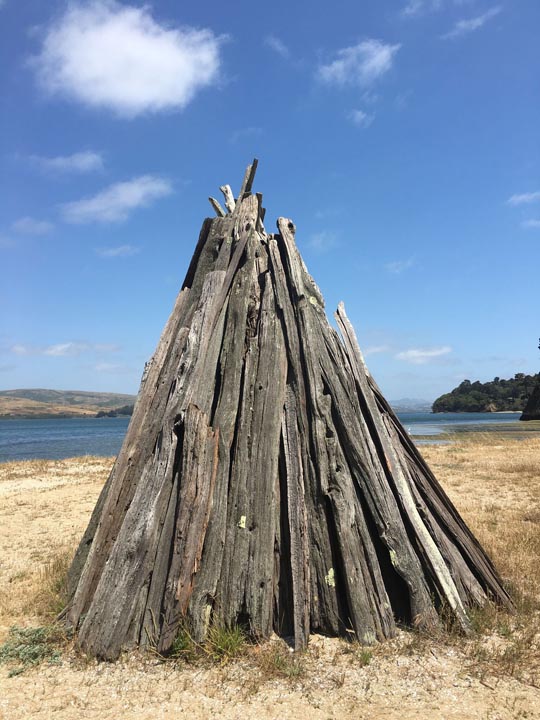
A short hike at Tomales Bay State Park to Indian Beach led to several reproductions of cone shaped Miwok bark shelters as part of a cultural exhibit.
On the way out of the National Seashore, we had one more stop on the beach, this time hitting Tomales Bay State Park, carved into the western edge of the bay, taking a short hike from Hearts Desire Beach (which was full of picnickers, kayakers, and BBQ) to Indian Beach.
An unusual thistle like plant along the trail to Abbott's Lagoon
Unfortunately our weekend was coming to an end. Reversing course on Sir Francis Drake Blvd brought us back through Point Reyes Station where we stopped for lunch. Again, we ate well, as the comfort food prepared at Side Street Kitchen was simply amazing (oysters, pork Belly BLT, pulled pork sandwich, salad). We picked up some cheese to take home across the road at Cowgirl Creamery, and returned to civilization through Nicasio Valley back to Oakland.
Lupins along Drake's estuary along the Estero trail
Despite packing a lot into the weekend, we felt refreshed and recharged for the week ahead. It felt like we barely scratched the surface of Point Reyes National Seashore and Tomales Bay, and left wanting to return for more. In particular, the Tule Elk Preserve on the northern tip, on the way to Tomales point, as well as the more famous and picturesque lighthouse at the opposite end, are on the list of things to get to on our next visit, or even camp in the park. Another trip will have to be made to actually kayak on Tomales Bay (Blue Waters Kayak) as well.
With only a small amount of traffic leaving Oakland, it took us around 1 hour, 20 minutes to get from the Bay Area to Inverness and Point Reyes.  For a map of Point Reyes click HERE. I hope you enjoy this report and are able to experience this area of California for yourself.
Abandoned fishing boat providing the classic Inverness snapshot


This article was first published July 2, 2018.

All text and photos copyright Caroline Arnold.

Monday, June 21, 2021

SUNDIAL BRIDGE, Architectural Wonder in Redding, California

 52 Places to Go: Week 25

Sundial Bridge, Redding, CA. The pylon is so tall (217 feet) I had to tip my camera sideways to get it all in.
In the spring of 2014, I was in Red Bluff, California, doing presentations to students in the historic renovated State Theater. At the north end of the San Joaquin Valley, Red Bluff is about 100 miles from Sacramento along Route 99.  From the main street of this charming Victorian town I could see across the Sacramento River to the snow-capped top of Mount Lassen to the west.

State Theater, Red Bluff, CA
One afternoon, after my presentations were finished, I drove 30 miles north to Redding to see the famous Sundial Bridge and take a walk along the river.  The Sundial Bridge, opened July 4, 2004, spans the Sacramento River at Turtle Bay. A suspension bridge designed by Spanish architect Santiago Calatrava, it is both beautiful and eco-friendly. The huge pylon (the sundial arm) connects to cables that support the bridge, allowing it to avoid interrupting the nearby salmon-spawning habitat since there are no supports in the water.  
The bridge walkway is made of steel, glass and granite.
The translucent glass surface lets light through to the water’s surface, both adding to the bridge's aesthetic qualities and minimizing its impact on river life. The bridge is open only to pedestrian traffic.  The view from the bridge is magnificent. Looking west toward the foothills and coastal range, I watched a fisherman trying his luck and a flock of Canada geese floating in the water.
Sacramento River, Redding, CA, view from the Sundial Bridge
I walked across the bridge from the south side of the river, ending at a large open area ringed with markers showing where the tip of the sundial’s shadow falls at the summer solstice.
At noon on the Summer Solstice, the Sundial's shadow reaches this marker.
From there I took a short walk in the Botanical Garden where a variety of spring flowers were in bloom.
Botanical Garden in the McConnell Arboretum
When I returned to the other side, I visited the Turtle Bay Museum, a small nature museum with exhibits featuring wildlife along the river.  I then walked along part of the extensive trail system that borders the river. It was a beautiful spring day and I was hoping to catch sight of the bald eagles that I was told had a nest along the river.  I didn’t spot any eagles but heard numerous smaller birds and saw plenty of ducks and geese in the water. Someday, I’d like to go back when I have more time and bicycle along this beautiful stretch of California river habitat and enjoy more of its wildlife.

For more about my visit to Red Bluff, see my May 28, 2014 post at Caroline Arnold's Art and Books.

Sacramento River Trail near the Turtle Bay Museum

This article was originally published 9/29/14.

All text and photographs copyright Caroline Arnold


Monday, June 14, 2021

MOUNT PINOS, Southern California: On Top of the World

 52 Places to Go: Week 26

Mount Pinos. View to the northeast, across the San Andreas Fault
Mount Pinos, just 90 miles north of the heart of Los Angeles, is one of Southern California’s best kept secrets. In the Los Padres National Forest, on the border of Kern and Ventura Counties,  it is the perfect place to get away from city life and immerse oneself in the natural world.
Trail to our favorite picnic spot
At 8,848 feet elevation Mount Pinos is the tallest mountain in the Tehachapis. The indigenous Chumash tribe still considers Mount Pinos a sacred site. From the top one looks west toward the coastal range, south across the Tehachapis, and north across the San Andreas fault toward the Central Valley.
Indian paintbrush
On a clear winter day one can see the snow capped peaks of the Sierras fifty miles away. In spring and summer, wildflowers bloom on the open slopes. It is one of our favorite places to hike--summer, fall, winter, spring-- and only an hour and a half drive from Los Angeles. After following the long, winding road up the mountain from Frazier Park, we park in a large lot at the beginning of the trailhead. (The parking lot is a favorite for star gazing because of the clear air and relative lack of light pollution. We have often arrived at the parking lot to find it full of telescopes and stargazers resting as they wait for night to fall.)
The bark of the Jeffrey pines have a characteristic caramel smell.
The path starts out through a forest of tall Jeffrey pines and ends up on the open, rocky slopes of the summit.
Beginning of the trail
The hike to the summit is about two miles from the parking area, or about four miles round trip. The trail gradually ascends. We usually take a picnic lunch and stop at our favorite overlook.
Informational display at the summit
Mount Pinos, "Iwihinmu" in the Chumash language, was considered by the Chumash Native Americans to be the center of the world ("Liyikshup"), the point where everything was in balance. A display at the summit provides information about the Chumash and the animals of the region. Another marker honors Vincent Tumamait, a beloved Chumash story teller.
Memorial to Vincent Tumamait

The trail continues from the summit to Mount Abel, six miles to the west. We have done that hike several times (a fairly strenuous up and down trail) and arranged to be picked up at the other end. But most often, our goal is the top of Mount Pinos, always an inspiration.
For information about hiking and other activities on Mount Pinos, click HERE.

This post was first published 10/2/17.

All text and photographs copyright Caroline Arnold.

Monday, June 7, 2021

JACK LONDON HISTORIC STATE PARK, Glen Ellen, CA

52 Places To Go: Week 23

The Cottage, Jack and Charmian London's home at their ranch in Glen Ellen, CA

Jack London (1876-1916), renowned author of Call of the Wild, White Fang, Sea Wolf and dozens of other novels, short stories, articles and poetry, is one of America’s most famous and prolific writers, as well as an adventurer, activist, and international celebrity. From 1905 to 1916, he and his wife, Charmian, lived on a property they called Beauty Ranch in Glen Ellen, California, about an hour and half north of San Francisco in the Sonoma Valley. This is where he wrote, operated a small farm demonstrating sustainable farming practices, and where Jack and Charmian built their dream house. Tragically, the house burned down shortly before they were to move in. After Jack's death in 1916, Charmian built another house, now restored as a museum at Jack London Historic State Park.
"Jack London Historical State Park. This is the “House of Happy Walls” built in 1919 by Charmian K. London in memory of her husband, Jack London, renowned author. Here are housed many of his works and the collection gathered in their travels throughout the world. Charmian’s house, the ruins of Jack’s “Wolf House,” and his grave were presented in 1960 to the state of California by his nephew, Irving Shepard."
In mid-May, when I was in Oakland, Art and I and our daughter spent a day at Jack London State Park, enjoying the fresh spring air and reacquainting ourselves with Jack London's literary legacy. The park had only recently opened after being closed due to Covid. It was a weekday, and when we arrived the parking lot was nearly empty. 

A shaded walkway leads to the Visitor Center

From the parking lot we did a short walk to the museum/visitor center, finding it filled with photos, video displays, books, mementos of Jack and Charmian’s extensive travels, and a peek into Charmian’s personal life--her dozens of shoes, piano, the decor of her kitchen and bathrooms. A friendly docent answered questions and managed the gift shop.

"As a child, Jack was a bright and voracious reader but his early years were spent in work. With what he called “dig,” Jack entered a short story contest sponsored by the local newspaper and won it. He enrolled in school and contributed several short stories to the school’s literary magazine. Later he withstood the pain of hundreds of rejection letters before winning worldwide fame."


Jack London's typewriter. "Jack’s daring explorations provided the fodder for his writing and the fuel for his spirit."

 
Jack London died in 1916 at the age of 40. His grave site, about a fifteen minute walk from the Visitor Center, is on a wooded hillside. A short distance away are the remains of Wolf House.

While I had long known about Jack London and his books, until this visit to his home I had been unaware of the role of his wife Charmian, who, I discovered, was just as bold and adventurous as he was. She edited Jack's work and was an author in her own right. She outlived Jack by nearly forty years, and died in 1955.

"Charmian K. London defied every expectation of the Victorian female. Obedient and chaste? Never. She was bold and free. Soul of a rebel. Kicking aside the convention that women must ride side saddle, Charmian chose to gallup astride. Every bit Jack’s equal in terms of adventure and intellect, she redefined a woman’s place."

Wolf House.
After viewing the exhibits at the museum we followed the path through the woods to the grave sites of Jack and Charmian, and from there to the ruins of their grand house. 

A swimming pool was to be the center of the house.

Built of stone, the remaining walls and chimneys of Wolf House look more like a medieval castle than a private home. Surrounded by towering redwoods, the house would have been an ideal retreat from city life. We climbed onto a platform that gave a view through the open doors and windows and a diagram of the layout, which included a swimming pool overlooked by a balcony.

Remains of farm buildings of Beauty Ranch.
Beyond the fence vineyards climb the Sonoma hills.

After our walk to the grave site and house, we returned to the parking lot and drove into Glen Ellen (a few minutes away) for a delicious lunch of sandwiches and pastries on the patio of Les Pascales, a French boulangerie. When we returned to the state park, we parked on the other side of the entrance for a tour of the Cottage  and of the remains of the farm buildings. During the years before Jack's death, he and Charmian lived in the cottage when they weren't traveling. Because of Covid, only one family group was allowed inside the Cottage buildings at a time for tours led by extremely knowledgeable volunteer docents. The rooms are preserved with furniture and decorations as they were when the Londons lived there.

The bed in the corner of the Cottage screen porch is where Jack London died.


View from the screen porch to the front garden and fish pond.