Showing posts with label trails. Show all posts

Monday, May 5, 2025

RED ROCK CANYON, LAS VEGAS, NEVADA: Towering Rocks, Hiking Trails, Ancient Rock Art in the Mojave Desert

Red Rock Canyon, Las Vegas, Nevada.

Just outside the bustling city of Las Vegas, Nevada, is Red Rock Canyon, a conservation area with monumental rocks, miles of hiking trails, and intriguing ancient rock art. A 13-mile one-way scenic drive, beginning at the Visitor Center near the park entrance, provides an overview of the many special features of the park and opportunities to take photographs.

One of many hiking trails at Red Rock Canyon.

On a Friday afternoon at the end of March, my husband Art and I visited Red Rock Canyon. I had paid the entrance fee in advance online and had my ticket handy as we arrived at the fee station. (A limited number of cars are permitted at each entry time to prevent crowding at the parking lots at the various viewpoints.) It was a beautiful day—partly cloudy and mild weather.  In summer, the temperature can reach 120 degrees Fahrenheit!

Entrance to Visitor Center.

We stopped first at the Visitor Center, where we talked to a ranger who gave us a map and advice on places to go on short hikes. Along the back wall of the Visitor Center there appeared to be a giant mural of the rock formation that gives Red Rock Canyon its name, but as we got closer we realized that we were looking through a huge picture window and the scene was real. It was our preview of what we would see close-up on our scenic drive. 

View of Calico Hills from the Visitor Center.

Displayed along the window sill were baskets and other objects made by Native Americans from the area.

Native American figure on display at the Visitor Center.

The Visitor Center also has a place to buy snacks and drinks and a well-stocked gift shop. We had brought a picnic lunch. While we ate in the picnic area behind the Visitor Center we watched a pair of white-tailed antelope squirrels scurrying among the cactus and under the tables, foraging for dropped crumbs. Unlike most desert wildlife, the squirrels are active in the daytime, holding their tails over their backs like tiny umbrellas.

View from the first parking area on the Scenic Loop drive. Note tiny figures on the rock.

Our first stop on the scenic drive was the overlook of Calico Basin where massive red rocks rise up from a dry valley. It was only when we realized that the tiny dots along the path below and on the rock were people, that we understood the scale of the rock.

We looked for the tortoise at the parking area but didn't see it.

Both of us were reminded of our visit many years ago to Uluru (also known as Ayers Rock), the giant red rock in the middle of the Australian desert. The geology of the two formations is different, but both are huge and both are red. The red color is the result of iron oxide (basically rust). Colors of other rocks in the park come from different combinations of minerals and geologic processes.

Our second stop was at the sandstone quarry. In the 19th century, local settlers had quarried the stone for building.

Stone blocks in the old quarry.

Along the path to the quarry we passed a manzanita in bloom, with its clusters of small bell-shaped flowers. We had hoped to see more spring flowers, but we were a bit early in the season.

Manzanita blossoms.

We then continued on the scenic drive, past the Hight Point Overlook (at an elevation of 4771 feet) to the turn-off for the Petroglyph Trail. There we followed the short, but rocky path to the base of a large rock wall where dozens of drawings were chipped into the stone. 


Petroglyphs at the end of the Petroglyph Wall Trail.

While some drawings resemble animals (bighorn sheep in some cases) and others appear to be a kind of record keeping, no one knows for sure what the symbols mean. There are also handprints “painted” in red. The images were made by ancient Americans who lived in Red Rock Canyon more than 800 years ago.

Hand prints made with iron oxide.

After another short hike, we returned to the scenic drive and made out way to the end at the highway leading to Las Vegas, about a half-hour away. We had enjoyed a good taste of Red Rock Canyon in the few hours we spent there. Someday we’ll have to go back to take some of the longer hikes and see more.

View of the Calico Basin looking southeast.

The Red Rock Canyon National Conservation area is operated by the Red Rock Canyon Conservancy. For more information about Red Rock Canyon and making a reservation to visit, go to the Red Rock Canyon website.

Red Rock Canyon formations are the result of millions of years of geologic action.

Monday, July 24, 2023

DESCANSO GARDENS, La Canada Flintridge, CA: Something in Bloom at Every Time of Year

Descanso Gardens, La Canada Flintridge, CA

Recently, when June Gloom brought day after day of cloudy weather to the California coast, we headed inland to get some sun. Our destination: Descanso Gardens, tucked in the hills of La Canada Flintridge, California, just a few miles from downtown Los Angeles. It was the perfect escape into nature from surrounding city life. Its many trails go through cultivated gardens and Southern California’s natural landscape. 

Climbing roses.

Famous for its camellias and tulips in the spring, Descanso Gardens has something new in bloom at every time of year. During our visit in June, the roses were in full bloom, as were the early summer garden flowers and wildflowers on the hillside.

Succulent in bloom.

After purchasing our tickets, we headed down the main promenade, past the seasonal plantings, before deciding which path to take.

Roses.

The gardens include a network of paths ranging from paved walkways to more secluded trails. Using a map we picked up at the entrance to guide our way, we made a circular tour of the gardens, starting with the promenade and roses, then walking around the lake to the oak woodland and California garden, then through the camellia forest and Japanese garden before returning to the entrance.

View of San Gabriel Mountains.

We made our way uphill to the California garden and got a view of the valley and the mountains beyond. 

Giant chalk dudlea.

Along the path we discovered California's only native succulent, Dudleya, and some of its relatives. 

Lizard.

As we walked along we kept an eye out for wildlife that makes the garden its home. An addition to birds, we spotted a ground squirrel, turtle, a mother mallard with her offspring, and a lizard that popped up on top of a fence, performed several pushups, and then scampered away.


Koi in the Japanese Tea Garden.

Throughout the gardens there are numerous benches and shelters inviting one to sit and enjoy the scenery. 


Poppies.

A visit to the garden is always an opportunity for photography, especially close-ups.


So many plants. So little time. We missed seeing the hilltop gardens and Ancient Forest. We’ll have to go back another day.


 For information about visiting Descanso Gardens, go to their website.

Monday, September 20, 2021

CHIMNEY ROCK STATE PARK, NORTH CAROLINA: Hiking, Nature, and Spectacular Views

52 Places to Go: Week 38

Chimney Rock, North Carolina

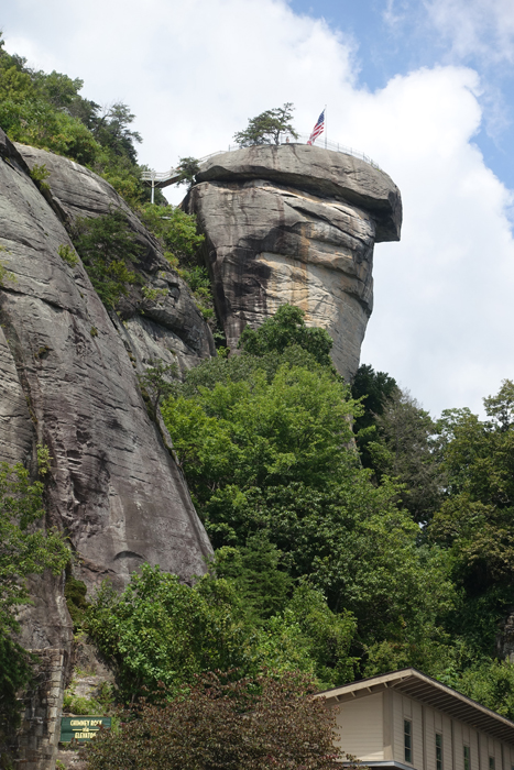
We stood at the railing and gazed almost one thousand feet below to Hickory Nut Gorge and the hills beyond. Like a silver ribbon, the Rocky Broad River threaded its way down the valley into Lake Lure. Above us, steep granite cliffs rose another 400 feet and the towering monolith of Chimney Rock was just a few steps away. We were with our family in Western North Carolina at Chimney Rock State Park for a day of hiking and sightseeing. 

View of Hickory Nut Gorge from the patio outside the Sky Lounge at Chimney Rock

Chimney Rock has a long history. After nearly a century of private ownership, when Chimney Rock was operated as a popular tourist attraction and nature preserve, it became a North Carolina State Park in 2007. During our family vacation at Lake Lure in August, it was on the top of our list of things to do. At Chimney Rock Village, a small community with hotels and tourist shops along the river, about a half hour from our rented house, we followed the sign into the park. 

After crossing the river we wound our way up to the entrance and bought our tickets for the day. By the time we arrived (about 11:00 am) the upper parking lot was full. We were directed to the lower parking area, the Meadows, and caught a shuttle bus to the parking area at the base of Chimney Rock. But we weren’t there yet! 

Stairway from the upper parking lot to Chimney Rock.

The energetic members of our family climbed a series of stairs from there to the top. Art and I took the elevator–blasted into the rock in the past by the original owners--and shot up nine stories to the top in less than a minute, and with much less effort than it would have been to walk.
Chimney Rock, Elevation 2280 feet (315 meters)

From the patio outside the Sky Lounge a short stairway led to the top of Chimney Rock–but even from the railing of the patio the view was spectacular. After appreciating the view, we bought sandwiches at  the café inside the Sky Lounge and ate them at a picnic table outside.
Beginning of Hickory Nut Falls Trail.

There are numerous opportunities for hiking in the park. After lunch, we took the Hickory Nut Falls trail, which begins at the end of the upper parking lot, going down stairs to join the trail.

Trail to Hickory Nut Falls is 1.4 miles round trip.

Following a wide, shaded path we walked gradually uphill through thick woodland. Scenes from several movies have been shot in Chimney Rock park, including Last of the Mohicans, and as we walked through the forest it was easy to imagine that the scenery must have been much the same long ago when the area was inhabited by Native Americans.
Hickory Nut Falls is formed by Falls Creek, which starts from natural springs on the top of Chimney Rock Mountain. 

At the end of the trail, Hickory Nut Falls cascade down the granite face of the mountain. At a height of 404 feet, it is one of the highest waterfalls east of the Mississippi. 

View from the bottom of Hickory Nut Falls toward Hickory Nut Gorge. The stream continues down a rocky ravine into the Rocky Broad River.

While resting on the rocks at the base of the falls, we caught our breath and watched dozens of fish swimming in the shallow pool. While our family was not alone admiring the falls, it wasn’t crowded, and it was easy to keep our social distance from other people.
Hickory Nut Falls.

We visited Chimney Rock on a sunny August day, midweek. The temperature was warm, but comfortable for hiking. The park is open year-round with activities to fit the season. For more information about visiting Chimney Rock, click HERE.

The round trip to Hickory Nut Falls (1.4 miles) takes 45 minutes--1 hour.


All text and photos copyright Caroline Arnold at The Intrepid Tourist.


Monday, August 31, 2020

WALKING IN ALTON BAKER PARK IN EUGENE, OREGON, Guest Post by Caroline Hatton


Walkers, runners, and cyclists share this path along the Willamette River
in Alton Baker Park, Eugene, Oregon

My friend and fellow children’s book author Caroline Hatton took all the photos in this post in recent years when she enjoyed this free outdoor activity on her visits to Eugene, Oregon.
Canada geese. Alton Baker Park is a good place for family activities.
When in Eugene in the Spring and Summer, my days often start with a walk in Alton Baker Park in the heart of the city. The park’s 400 acres (~162 hectares) stretch along the Willamette River. The park is named after Alton F. Baker, Sr, who was a local newspaper owner and philanthropist.

Swan Goose (Anser cygnoides) on a pond.
I love the wild river banks and natural forest, and the abundance and variety of birds. On many days in the same spot, a Great Blue Heron (Ardea herodias) flew over as if in slow motion. A Swan Goose (Anser cygnoides) on a pond was my first sighting of its species. But the most fun were the rare geese that didn’t match any bird website photo, probably because their parents didn’t look alike, but they fell in love anyway.

No crowd, early in the morning.
At 6 a.m. I rarely encounter other humans. When I did on the wide paths I chose, physical distancing was easy.

On this Kalapuya Talking Stone, the word “camafeema” means “ferns on the ground” in the local indigenous language.
To honor the Kalapuya, the indigenous people who once called this area home, trailside Kalapuya Talking Stones display words in their language along with the English equivalent. I stopped by each stone to honor those who walked there before.

Alton Baker Park is bejeweled with art works.
The park showcases art works, and contains venues for cultural and sports events. Until I came upon a disc golf target (like a basket made of chains, mounted at chest level), I had never heard of this game, played with a flying disc reminiscent of a frisbee.

A bucolic spot.
My idea of fun with water is to stay out of it and look for interesting photos to take. The park’s varied bodies of water offered endless possibilities to me. Those who don’t mind getting wet can launch a boat on the river or, for calmer water, on the man made  Canoe Canal, stocked with trout for better fishing luck.

Vast open fields add to the diversity of environments in the park.
I have explored miles of paths through forest and prairie in the park. Runners passed me on Pre’s Trail, designed by the late Steve Prefontaine, the long-distance running legend who lived in Eugene. 

Other outdoor attractions in Alton Baker Park include the dog park, the scaled models of the sun and its planets on the Eugene Solar System Trail, and the Nobel Peace Park area, which honors American laureates. But what I want to see next is the Hays Tree Garden, filled with trees chosen for their foliage and donated in honor of loved ones.