Showing posts with label nature. Show all posts

Monday, February 17, 2025

A PERSONAL GUIDE TO TUCSON, ARIZONA, Part 2: Guest Post by Paul Justison


Goddess of Agave, painted by Rock "Cyfi" Martinez, 2017, Tucson, AZ 

With many thanks to my friend Paul Justison for his excellent guide to the city of Tucson, posted here in two parts--Part 1, last week and Part 2, this week. Paul is the author of the well received novel Lost and Found in the 60s (Unsolicited Press, 2022.)

What to see — Science and technology 

During the cold war, Tucson was a one of the main launching pads for nuclear attacks on the Soviet Union. Davis-Monthan Air base was adjacent to the city and housed nuclear armed B-52 bombers. It was also surrounded by 18 silos that held nuclear armed missiles. They are all decommissioned now. One of them is now a museum, and even I, an antiwar peacenik, found the tour fascinating. Home | Titan Missile Museum It’s about 30 minutes south of town. And since you’ve gone that far, you might consider two places about 25 minutes further south. Tumacácori is the site of a precontact Native American trading center. The Jesuits and Franciscans built missions there, and the fairly intact remains of the Franciscan mission are the core of the Tumacácori National Historical Park (U.S. National Park Service) . The buildings are rather austere and together with the exhibits give you a good impression of what precontact and mission life was like. Nearby is Tubac, a little town filled with arts and crafts shops and one fun Mexican restaurant — Elvira’s Restaurant Tubac, Arizona Reservations are advised.

About ten minutes southeast of town in the Pima Air and Space Museum Home — Pima Air & Space . It houses 400 or so historic aircraft outdoors and in hangars. If you’re into planes, this should be on your list.

On the University of Arizona campus is the Flandrau Planetarium Home | Flandrau Science Center & Planetarium . The shows in the planetarium are fun and educational. Before you go, read on the site above about parking.

The SunLink Streetcar and Neighborhoods/Shopping/Nightlife –

Bahti Indian Arts Tucson — Bahti Indian Arts is one of the best shops in the nation for native American arts and crafts. It’s in the Barrio Historico which is itself worth a walk or a drive around. Barrio Historico Tucson Is One Of Arizona’s Oldest Neighborhoods

Tucson has a free modern streetcar that runs through most of the interesting areas in the center of the town — Sun Link Streetcar — Sun Tran One end is near the Banner University Medical Center at the corner of Helen and Warren, and about a 10 block walk from the Arizona Inn. From there it runs along the northern and western sides of the U of A — and very near the photography museum and the Flandrau planetarium. It then heads along the commercially hip area — Fourth Avenue, where there’s a nice bookstore — Antigone Books , along with many shops and restaurants. Next it goes downtown, the center for Tucson’s nightlife. Last, it ends at the Mercado San Agustin — What’s Here — Mercado District

A few words about nightlife and restaurants –

As I mentioned in the introduction, UNESCO has declared Tucson a “City of Gastronomy.” If you’re a Reddit user, go to r/Tucson and search for restaurant types, or simply start your own thread with a question. You will likely get many helpful responses. Also, the Tucson Weekly: The Best of Tucson, News, and Everything That Matters is a great resource for the ever-changing nightlife scene.

Photo Credit — Goddess of Agave — When In Your State

Paul has previously published A Personal Guide to Tucson, Arizona, on the web at Medium.

Monday, February 10, 2025

A PERSONAL GUIDE TO TUCSON, AZ, Part 1: Guest post by Paul Justison

Goddess of Agave, painted by Rock "Cyfi" Martinez, 2017, Tucson, AZ 

With many thanks to my friend Paul Justison for his excellent guide to the city of Tucson, posted here in two parts--Part 1, this week and Part 2, next week. Paul is the author of the novel Lost and Found in the 60s (Unsolicited Press, 2022.)

I spent my formative years in Tucson and go back often, because it’s special in many ways. Tucson sits in a high Sonoran Desert valley surrounded by mountains. The Catalinas to the north will command your attention. Many cultures have thrived here — Yaqui, Tohono O’odham, Spanish, Mexican, and after the USA bought the area from Mexico in 1848 — Anglo-Americans. Politically it tends to be left of center. When the Arizona legislature passed a bill that discriminated against Mexican Americans, the local — Pima County — sheriff refused to implement it. And today Tucson honors the Native American and Mexican food traditions for which it was recognized by UNESCO as a “City of Gastronomy.”

When to Go

It can get hot. Dry heat, but really hot — high 90s to low 100s. October through April is best with rarely cold and usually cool to mild temperatures, though early October and late April can still be quite warm. There’s still plenty to do and see in the summer, and hotels will be far less expensive. Just be prepared for serious heat.

Where to Stay

Tucson has accommodations in all types and price ranges, from luxury dude ranches, health and golf resorts to budget motels and B&Bs. I have one favorite and almost always stay there — the Arizona Inn — A Historic Boutique Hotel Retreat in Tucson | Arizona Inn . Linda Ronstadt, who grew up in Tucson, called it her favorite hotel in the world 5 Places to Visit in Tucson, Arizona, With Singer Linda Ronstadt — The New York Times . To me, the Inn is an oasis of beauty, calm, and exceptional food.

What to see — Natural environment

Undoubtedly the best place to learn about the plants and animals of the Sonoran Desert is The Arizona-Sonora Desert Museum — Arizona-Sonora Desert Museum, Tucson, AZ — Zoo, Botanical Garden and Art Gallery . It’s an aquarium, botanical garden, natural history museum, and zoo all rolled into one fascinating experience. The roughly 10-mile drive west from downtown will take you through foothills sprinkled with houses, over Gates Pass and down into a sahuaro cactus-filled valley. You will always remember your visit.

There are three great places to hike or wander around the desert. First, Sabino Canyon is about 10 miles northeast of the center of town. What makes this canyon so popular is both the almost always flowing waterfalls and the marvelous collection of massive boulders deposited throughout the canyon by an 1888 earthquake. It’s a popular place to visit, so you’ll have to park and take a shuttle to the hiking trails or just ride the shuttle to and from the lot. Coronado National Forest — Sabino Canyon Recreation Area

Second and third are the two Sahuaro National Park sites, one east and one west of town — Saguaro National Park (U.S. National Park Service) . Both have many hiking trails to get you into the desert and up onto viewing platforms. Unlike Sabino though, there will rarely be flowing water.

Lastly, in mid-town, you’ll find the Tucson Botanical Garden. If you can’t make it to the Desert Museum, this is a reasonable alternative for learning about desert plants, and it has a fun butterfly exhibit to walk through. Tucson Botanical Gardens — Your Urban Oasis in the heart of Tucson

What to see — Art

One of my favorite small museums in the world is the Center for Creative Photography — About CCP | Center for Creative Photography It houses the archives of Ansel Adams and many other renowned photographers. Of interest to casual photographers and art lovers are the exhibitions they regularly host. I’ve seen exhibitions of Linda McCartney and Louis Carlos Bernal here. Well worth your time and it’s free, though check their calendar for sometimes they are between exhibits.

About a ¼ of a mile away on foot is the Arizona State Museum, which has a fine collection of Native American basketry, jewelry and pottery. Unfortunately, it’s closed for renovations until late 2026. Their website has much of the collection online and updates on the renovations. Home | Arizona State Museum

There are so many spectacular murals all over town that there are websites devoted to cataloguing them. Here are a few of those. The Tucson Murals Project ; 100+ murals in Tucson, plus a map | tucson life | tucson.com ; Tucson Murals If you’re interest in the murals. Peruse one or more of the above and then go on a mural hunting tour. If you’re short on time, I have two suggestions. My absolute favorite mural is the All Souls Procession by Susan Kay Johnson. It actually has an entry in the Library of Congress — Colorful Tucson, Arizona, is a city replete with murals, including several of gigantic proportions. Here, a portion of the All Souls Procession mural by local artist Susan Kay Johnson — original digital file | Library of Congress It takes up the entire block of 9th Avenue between University and 4th Street. And while you’re there, walk or drive slowly around the neighborhood. For it’s one of many quirky Tucson neighborhoods.

Two of the most monumentally spectacular murals are in sight of each other, but they are separated by one of the geometrically weirdest intersections, so take care in getting to them. The official address of the Goddess of Agave is 440 N. 7th Avenue which is Benjamin Plumbing Supply. Put that address in your GPS and park in their lot, but please not in one of the close in customer spots unless you are also looking for plumbing partsBenjamin Supply also has a description of the mural on their website — Benjamin Supply — Tucson-AZ — but ignore the 6th street address. There’s no access to parking from that address. From that lot you can also see another spectacular mural — Epic Ride. Here’s the story behind that mural and two others These are Joe Pagac’s favorite murals he’s created in Tucson | tucson life | tucson.com

Monday, September 20, 2021

CHIMNEY ROCK STATE PARK, NORTH CAROLINA: Hiking, Nature, and Spectacular Views

52 Places to Go: Week 38

Chimney Rock, North Carolina

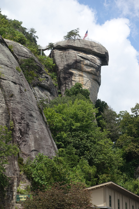
We stood at the railing and gazed almost one thousand feet below to Hickory Nut Gorge and the hills beyond. Like a silver ribbon, the Rocky Broad River threaded its way down the valley into Lake Lure. Above us, steep granite cliffs rose another 400 feet and the towering monolith of Chimney Rock was just a few steps away. We were with our family in Western North Carolina at Chimney Rock State Park for a day of hiking and sightseeing. 

View of Hickory Nut Gorge from the patio outside the Sky Lounge at Chimney Rock

Chimney Rock has a long history. After nearly a century of private ownership, when Chimney Rock was operated as a popular tourist attraction and nature preserve, it became a North Carolina State Park in 2007. During our family vacation at Lake Lure in August, it was on the top of our list of things to do. At Chimney Rock Village, a small community with hotels and tourist shops along the river, about a half hour from our rented house, we followed the sign into the park. 

After crossing the river we wound our way up to the entrance and bought our tickets for the day. By the time we arrived (about 11:00 am) the upper parking lot was full. We were directed to the lower parking area, the Meadows, and caught a shuttle bus to the parking area at the base of Chimney Rock. But we weren’t there yet! 

Stairway from the upper parking lot to Chimney Rock.

The energetic members of our family climbed a series of stairs from there to the top. Art and I took the elevator–blasted into the rock in the past by the original owners--and shot up nine stories to the top in less than a minute, and with much less effort than it would have been to walk.
Chimney Rock, Elevation 2280 feet (315 meters)

From the patio outside the Sky Lounge a short stairway led to the top of Chimney Rock–but even from the railing of the patio the view was spectacular. After appreciating the view, we bought sandwiches at  the café inside the Sky Lounge and ate them at a picnic table outside.
Beginning of Hickory Nut Falls Trail.

There are numerous opportunities for hiking in the park. After lunch, we took the Hickory Nut Falls trail, which begins at the end of the upper parking lot, going down stairs to join the trail.

Trail to Hickory Nut Falls is 1.4 miles round trip.

Following a wide, shaded path we walked gradually uphill through thick woodland. Scenes from several movies have been shot in Chimney Rock park, including Last of the Mohicans, and as we walked through the forest it was easy to imagine that the scenery must have been much the same long ago when the area was inhabited by Native Americans.
Hickory Nut Falls is formed by Falls Creek, which starts from natural springs on the top of Chimney Rock Mountain. 

At the end of the trail, Hickory Nut Falls cascade down the granite face of the mountain. At a height of 404 feet, it is one of the highest waterfalls east of the Mississippi. 

View from the bottom of Hickory Nut Falls toward Hickory Nut Gorge. The stream continues down a rocky ravine into the Rocky Broad River.

While resting on the rocks at the base of the falls, we caught our breath and watched dozens of fish swimming in the shallow pool. While our family was not alone admiring the falls, it wasn’t crowded, and it was easy to keep our social distance from other people.
Hickory Nut Falls.

We visited Chimney Rock on a sunny August day, midweek. The temperature was warm, but comfortable for hiking. The park is open year-round with activities to fit the season. For more information about visiting Chimney Rock, click HERE.

The round trip to Hickory Nut Falls (1.4 miles) takes 45 minutes--1 hour.


All text and photos copyright Caroline Arnold at The Intrepid Tourist.


Monday, July 1, 2013

JOAQUIN MILLER PARK in the Oakland, CA Hills: Nature and History

The Cascade in Joaquin Miller Park is the Amphitheater's waterfall feature. Built in 1941 and dedicated to California writers, it still flows with water. It was designed by Howard Gilkey,
On a recent Saturday afternoon, I went with my family to Joaquin Miller Park in the Oakland hills for a hike, and to see the legacy of Joaquin Miller, the 19th century poet who spent the last years of his life in what is now the park named after him.  It was a beautiful warm day, perfect for walking the trails up the hills and through the redwoods.

We climbed up the long stairs from the lower meadow and playground, stopping at the fountain to watch the tadpoles.  Then we continued past the waterfalls to the amphitheater, where we set out on a trail through the woods
Numerous places in the Oakland area are named after Joaquin Miller so I was curious to find out who he was.  It turns out that Joaquin Miller was the pen name Cincinnatus Heine (or Hiner) Miller (September 8, 1837 – February 17, 1913), nicknamed the "Poet of the Sierras".  Before settling in Oakland, Miller had numerous adventures, working for a time in the mining camps during the California Gold Rush and later traveling to Alaska.


Pyramid to Moses, Joaquin Miller's symbol of belief in the Ten Commandments.
The Hights (his spelling), the Oakland home Miller built at the end of his life, is currently known as the Joaquin Miller House and is part of Joaquin Miller Park. He planted the surrounding trees and built nearby his own funeral pyre and monuments dedicated to Moses, General John C. Frémont, and the poets Robert Browning and Elizabeth Barrett Browning. (The Japanese poet Yone Noguchi began his literary career while living in the cabin adjoining Millers' during the latter half of the 1890s.) The Hights was purchased by the city of Oakland in 1919.  It is now a designated California historical site.

Resident goat herd
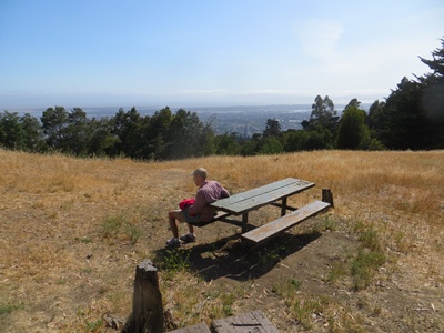
The park features include miles of hiking, biking, and horseback riding trails, an off-leash dog area, an amphitheater, and picnicking. As we circled back on our hike we passed the herd of goats that are used as natural landscape managers.  Surrounded by a moveable fence, they eat the undergrowth and keep it under control. We ended our walk at the top of the hill where Miller had built his Monument to Moses.  From the picnic area just below the monument there was a spectacular view of San Francisco Bay.  Joaquin Miller certainly knew how to pick a good spot for his final years.
The park's 500 acres (2.0 km2) are heavily wooded with coast redwoods, coast live oaks, and pines. Its location in the Oakland Hills provides panoramic views of the San Francisco Bay area.
For directions and more information about the park, go to the Joaquin Miller Park website.

Monday, August 13, 2012

ENO RIVER STATE PARK, Durham, NC: A Place to Enjoy Nature

Eno River, North Carolina
The Eno River is a swift, shallow stream that flows for 33 miles through Orange and Durham counties in North Carolina.  Its wooded shores and surrounding forest are home to birds, deer, and other wildlife, and have been preserved for public enjoyment as Eno River State Park.  On a recent visit to North Carolina, we went on a family outing to the park.  We began our visit with a naturalist program at the park headquarters where we learned about red-shouldered hawks, Cooper’s hawks, ospreys, eagles and other raptors (birds of prey) that can be seen within the park.  Many raptors, including bald eagles, are seen more easily during the fall migration season.  (We didn’t see any during our visit in July.)  We also learned that when the bald eagle was chosen as our national symbol, it almost lost out to the wild turkey, the bird preferred by Benjamin Franklin for our national symbol because of its industrious nature. Wild turkeys can also be seen in the park, along with more than one hundred species of songbirds, such as the cardinal, the North Carolina state bird, and water birds such as great blue herons and wood ducks.

Bridge across the Eno River
After the raptor talk we hiked down the trail from the visitor center to the river.  In the shallow water we watched fish dart among the rocks and dragonflies flit over the water’s surface.  We even saw a turtle.

Summer flowers bloomed along the path, which we followed along the river to a suspension bridge.  The narrow pedestrian walkway, which spans the stream to connect to a path on the other side of the river, provided a few thrills for the kids and a nice view down the river from the middle.  Afterward, the kids took off their shoes and splashed and cooled their feet in the stream.


Fungus on a fallen log, Eno River State Park
It was a warm day, as most summer days in North Carolina are, but the late afternoon hour and the shady forest made our visit a very pleasant and rewarding experience as we immersed ourselves in the natural beauty of North Carolina.

For more information about park hours and special activities click here.