Showing posts with label waterfalls. Show all posts

Monday, April 13, 2026

ON THE “ROOF OF NORWAY” – IN THE JOTUNHEIMEN MOUNTAINS: Guest Post by Caroline Hatton

Kyrkja (north face), Jotunheimen National Park, Norway.

My friend Caroline Hatton, a children’s writer and frequent contributor to this blog, took the photos in this post in July 2025.

Jotunheimen mountains (J), Norway (N), Oslo (O).*

To see the beauty of Norway, my husband and I targeted three natural wonders: the Lofoten Islands, fjords, and Jotunheimen mountains, the highest in northern Europe. They were named after one of the nine worlds of Norse mythology, the home of the giants. Who knows? Perhaps giants really live up there.

To day hike for a week in and near Jotunheimen National Park, while driving clockwise around it, we picked up a rental car in Åndalsnes after visiting the fjord region. We had reserved lodging for three nights near Bygdin, two nights in Tyinkrysset, and three nights in Lom (Google Maps finds it as Fossbergom), our closest stay to the highest mountains.

Driving to Bygdin on a sunny day, we watched for shiny waterfalls on the Troll’s Wall mountainside, stopped in an evergreen forest for a short walk to the Knight’s Leap, a rocky gorge narrow enough for a knight of legend to have leaped across to save his beloved, and enjoyed going through small towns, villages, and farmland.

We had planned a day hike to “the most beautiful valley in the Jotunheimen,” Svartdalen (Black Valley), to see lush meadows below snowy peaks and glaciers. We would take the earliest boat at one end of Lake Bygdin, get off at the trailhead, hike to the valley, and come back down in time to catch the last return boat.

But three weeks before this highly anticipated day, I received an e‑mail from the boat company apologizing for having to cancel and refund all boat tickets for 2025. The lake level was too low to launch any boat, in part because of insufficient spring precipitation.

Fortunately, there are many other trails around Bygdin. We almost reached the nearest peak for a first glimpse of the Jotunheimen, but we turned around because it was too windy and too steep near the end.

Lake Bygdin.


Instead, we walked on a level trail above and along Lake Bygdin. We learned to speak Norwegian in no time, by echoing the local hikers’ friendly greeting, which sounds like “hey‑hey!” (or “hey‑hey‑hey” for extra cheerfulness).

The next day, our favorite of several walks was in cool misty air, complete solitude, and bucolic loveliness, across hilly pastures toward Leirungsdalen Valley. The only tent we saw faced the best view of lakes and snowy mountains.

Farm.

On the drive to our next lodging in Tyinkrysset were farms straight out of fairy tales. We stopped to hike up to a bench with a lake view on a section of the King’s Road, a 1790s royal-carriage road restored as a hiking trail. We took a break in a kafé where the Dutch barista had no decaf because, he said, “Norwegians don’t drink decaf. They want full power!” On my request, he gladly poured one tablespoon (~15 mL) of strong coffee in a mug and filled it with hot milk.

Øye stave church.


In Øye, we ate grab-and-go sandwiches on a bench above the first of the three stave (vertical wooden boards) churches we would see. In the following days, we would also visit the famous Borgund church and walk around the one in Lom. To compare the three, the Øye church is the smallest, simplest, and plainest, but its setting is the loveliest. The other two churches are larger, have more roofs upon stacked roofs, and crosses and dragon heads adorning roof ridges. The Borgund church is the most authentic stave church in Norway—the least changed since it was built nearly a thousand years ago.

The King’s Road.

From Tyinkrysset, we visited the Borgund church, then walked downhill from there on the most spectacular part of the King’s Road. From the river at the bottom of the hill, we walked back on a trail through woods and farmland.

Lake Tyin.


On the scenic drive from Tyinkrysset to Lom, Lake Tyin is where locals fish for trout. Restaurants offer it baked the traditional Norwegian way, served whole with sour cream sauce, roasted potatoes, and pickled cucumber.

We spent all day driving the ~220 km (~134 mi) that take less than 3 hours nonstop, because we slowed down and stopped and strolled around at every tempting opportunity. After the first hour and a half (which included some narrow switchbacks), we turned uphill onto the second half of Norwegian NationalScenic Route Sognefjellet (Road 55), which goes over the highest mountain pass in northern Europe at 1434 m (~4700‘) to link a fjord to the inland valley where Lom is. The road, open June-October, follows an ancient trade route marked by hundreds of cairns.

In the perfect weather we had, with no storm, rain, fog or wind, our drive was easy in a regular car.

Identifying a peak.


At Nedre Oscarhaug, the first of six formal Rest Areas & Viewpoints, the peak-identification machine, cleverly and beautifully designed by architect Carl-Viggo Hølmebakk, is more fun to use than an app and way bigger than a phone.


To identify a peak, align the vertical wires with its tip and look down at the metal bar pointing at the name of the peak. The official road website at the above link calls the device a “glass telescope,” even though it doesn’t include any lens and doesn’t provide magnification.

Restroom.


At the Oscarshaug Rest Area & Viewpoint, one minute up the road by car, the contemporary restroom was designed by architects, Jensen & Skodvin Arkitektkontor. It was so high-tech, I had to ask the nearest rocket scientist to show me how to operate it.

Stone sculpture.


At the Mefjellet Rest Area and Viewpoint, I bet every visitor takes a snapshot through the stone sculpture by Knut Wold. The sight of snowy mountains and turquoise lakes makes my heart race, so traveling along the road from one pull-out viewpoint to the next took me straight to heaven.

A steep river.


After the pass, Road 55 descends past waterfalls and rivers, down to farmland. But approaching Lom, two spurs go up the adjacent massif. One spur leads to the Leirvassbu Mountain Lodge at 1400 m (~4600‘). The other climbs to the Spiterstulen Tourist Lodge at 1111 m (~3645‘). The two lodges are on an extensive network of trails, including one that links them by following a high valley.

The next day, July 18, we drove 50 minutes from Lom to Leirvassbu and started walking toward Spiterstulen at a good clip. Before long, we slowed way down. There were simply too many lakes and snowy peaks and photo opps, including entertaining encounters with free-ranging sheep with long, intact tails.

We crossed boulder fields on lake shores. Walking over rocks covered by a snow patch was easier for me, a petite hiker, than for heavier people, because I didn’t sink. Stepping on exposed uneven rocks, harder to reach with shorter legs, was the exact opposite. Soon, it was clear that we wouldn’t come close to the halfway point between Leirvassbu and Spiterstulen.

But why keep walking when one has arrived? I took the photo at the top of this post, of a distinctive leaning peak, found a comfortable rock to sit on, and whipped out my grab-and-go sandwich of the day.

Spiterstulen Tourist Lodge.


On July 19, our last day in the mountains before going back to Oslo to fly home, we drove 40 minutes from Lom to Spiterstulen. The trail to Leirvassbu was easy, across meadows along a rushing river, with a couple of high wooden footbridges over silty glacier runoff.

The views of peaks and snow and ice at every step were less sensational than those of the day before. This made the experience less intense and, especially with far fewer hikers around, more peaceful.

Kyrkja (east face).


That is, until the first glimpse of the leaning peak I had reached the day before flooded me with feelings of completion. From that point on, I basked in bliss, even though I never quite made it to that landmark.

 Anyone wishing to hike from one lodge to the other, which may require arranging a ride back, should definitely consider hiking uphill from Spiterstulen to Leirvassbu, from quiet to rousing beauty.

 Footnote:

 * Credit for the globe image: Rob984 - Derived from Germany on the globe (Germany centered).svg, CC BY-SA 4.0 via Wikimedia Commons.


Monday, March 13, 2023

ICELAND IN WINTER: Ice, Snow, and Spectacular Aurora Borealis, Guest Post by Owen Floody

Iceland

With many thanks to our friend Owen Floody for another exceptional contribution to The Intrepid Tourist.

Iceland has become a popular tourist destination, reflecting its accessibility, manageable size, and dramatic landscapes. Even in winter, Iceland has much to offer. Landscapes that are dramatic in other seasons can become even more so when mountains are dusted by snow, waterfalls are embellished by icicles, and low clouds add mystery and mood. Throw glacial ice caves and possible sightings of the aurora borealis into the mix and Iceland may be irresistible.

Aurora

However, Iceland doesn’t give up its treasures easily. Sightings of the aurora require a coincidence of elevated solar activity and clear skies. But Iceland’s frequent high winds and famously changeable weather can make the second, and thus the coincidence, hard to achieve.

At the same time, nothing ventured, nothing gained. With this in mind, I recently completed an 11-day Winter in Iceland photo tour led by Haukur Snorasson of Look North Travel (https://www.phototours.is). Given the weather-related and other challenges that Iceland can pose, one can benefit greatly from an expert’s efforts to match the best available scenes with route, time of day, and current conditions.

Rock striations.

Including Haukur, we were a group of six, packed comfortably in a carry-everything, go-anywhere van.  Most in the group were avid photographers.  How do you recognize an avid photographer?   In the past, a tripod and high-end camera would suffice.  Now, however, most in this sample of avid photographers were packing iPhones as well as cameras, and more discussion revolved around the images taken with the former.

Frozen waterfall.

Our tour covered a lot of ground.  Iceland’s “ring road” covers about 821 miles and we went a bit beyond it, especially to the north.   I was very happy to have Haukur driving.  The wind howled almost constantly, buffeting the vehicle and threatening to blow us off the road.  The fact that this threat was not just imagined was provided by the need to get over several passes before the winds closed them.  Lunch generally was fast food, but the hotels were great as were the dinners.  Not surprisingly, we had some of the best Arctic char ever, especially at the Mödrudalur Country Hotel (find that if you can!).

Waterfall and river.

The scenery more than met my expectations.  Almost everything that I saw on this trip I had previously seen under more benign conditions.  The winter conditions unquestionably made everything more dramatic.  Mountains emerged from or receded into the mist (first of images that accompany this column), rock striations and other formations jumped out at you, and ice arrested some waterfalls while embellishing others.

The rugged Iceland coast.

These were wonderful additions to Iceland’s usual fare of rugged coasts and glacier lagoons dotted with icebergs.  But what about our primary goals of seeing the aurora and getting into one or more ice cave? 

Stranded icebergs.

Here, I am happy to report that we were extremely fortunate.  We enjoyed good aurora sightings on three of our ten nights.  Our visit to a relatively isolated ice cave, one that we had all to ourselves, fell on the first day in a week on which the helicopter ferry was able to fly.  And our proximity to a second cave made it possible for us to plug ourselves into a gap created by weather-related cancellations of visits from farther afield (last image).  Some of this success reflected preparation and effort.  For example, we scoured multiple sources for tips on the nights and times at which the aurora might be visible and then we mounted expeditions or watches at all of the best times.  Nevertheless, it is clear that we were very lucky.   

Ice cave.

However, do not be fooled into thinking that this luck made the tour an entirely easy one.  The winds howled almost constantly, sometimes making it difficult to stand, let alone explore.  The temperature was only moderately low (about freezing) most of the time.  But there were some genuinely cold mornings and nights, and even the prevailing moderately low temperatures became frigid when combined with the typically high winds.  We dressed well and met most of these challenges.  Fingers, however, remained vulnerable: On more than one occasion, I had to cut short an aurora viewing because I could no longer operate my fingers or camera.  Footing was the other area of personal concern.  Wherever we were, the substrate typically was snow and ice.  Crampons that could be pulled on over our boots were a necessity.  On roads or sidewalks, the type featuring coiled wires were sufficient.  But many of our explorations (e.g., into ice caves, around waterfalls, or in search of sites from which to view the aurora) required more serious crampons, with real teeth. In Iceland and elsewhere, winter landscapes can be magical.  But they do require some season-specific preparations.

Click HERE for an earlier post (October 4, 2021) by Owen Floody about Iceland.

Monday, September 20, 2021

CHIMNEY ROCK STATE PARK, NORTH CAROLINA: Hiking, Nature, and Spectacular Views

52 Places to Go: Week 38

Chimney Rock, North Carolina

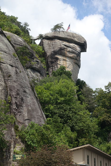
We stood at the railing and gazed almost one thousand feet below to Hickory Nut Gorge and the hills beyond. Like a silver ribbon, the Rocky Broad River threaded its way down the valley into Lake Lure. Above us, steep granite cliffs rose another 400 feet and the towering monolith of Chimney Rock was just a few steps away. We were with our family in Western North Carolina at Chimney Rock State Park for a day of hiking and sightseeing. 

View of Hickory Nut Gorge from the patio outside the Sky Lounge at Chimney Rock

Chimney Rock has a long history. After nearly a century of private ownership, when Chimney Rock was operated as a popular tourist attraction and nature preserve, it became a North Carolina State Park in 2007. During our family vacation at Lake Lure in August, it was on the top of our list of things to do. At Chimney Rock Village, a small community with hotels and tourist shops along the river, about a half hour from our rented house, we followed the sign into the park. 

After crossing the river we wound our way up to the entrance and bought our tickets for the day. By the time we arrived (about 11:00 am) the upper parking lot was full. We were directed to the lower parking area, the Meadows, and caught a shuttle bus to the parking area at the base of Chimney Rock. But we weren’t there yet! 

Stairway from the upper parking lot to Chimney Rock.

The energetic members of our family climbed a series of stairs from there to the top. Art and I took the elevator–blasted into the rock in the past by the original owners--and shot up nine stories to the top in less than a minute, and with much less effort than it would have been to walk.
Chimney Rock, Elevation 2280 feet (315 meters)

From the patio outside the Sky Lounge a short stairway led to the top of Chimney Rock–but even from the railing of the patio the view was spectacular. After appreciating the view, we bought sandwiches at  the café inside the Sky Lounge and ate them at a picnic table outside.
Beginning of Hickory Nut Falls Trail.

There are numerous opportunities for hiking in the park. After lunch, we took the Hickory Nut Falls trail, which begins at the end of the upper parking lot, going down stairs to join the trail.

Trail to Hickory Nut Falls is 1.4 miles round trip.

Following a wide, shaded path we walked gradually uphill through thick woodland. Scenes from several movies have been shot in Chimney Rock park, including Last of the Mohicans, and as we walked through the forest it was easy to imagine that the scenery must have been much the same long ago when the area was inhabited by Native Americans.
Hickory Nut Falls is formed by Falls Creek, which starts from natural springs on the top of Chimney Rock Mountain. 

At the end of the trail, Hickory Nut Falls cascade down the granite face of the mountain. At a height of 404 feet, it is one of the highest waterfalls east of the Mississippi. 

View from the bottom of Hickory Nut Falls toward Hickory Nut Gorge. The stream continues down a rocky ravine into the Rocky Broad River.

While resting on the rocks at the base of the falls, we caught our breath and watched dozens of fish swimming in the shallow pool. While our family was not alone admiring the falls, it wasn’t crowded, and it was easy to keep our social distance from other people.
Hickory Nut Falls.

We visited Chimney Rock on a sunny August day, midweek. The temperature was warm, but comfortable for hiking. The park is open year-round with activities to fit the season. For more information about visiting Chimney Rock, click HERE.

The round trip to Hickory Nut Falls (1.4 miles) takes 45 minutes--1 hour.


All text and photos copyright Caroline Arnold at The Intrepid Tourist.


Monday, August 16, 2021

FAROE ISLANDS: Land of Fjords and Green Cliffs, Guest Post by Tom Scheaffer

 52 Places to Go: Week 33

Faroe Islands Peace Run
In 2017 my brother Tom Scheaffer went on a two week trip to Iceland and the Faroe Islands. Tom’s trip was part of the Sri Chimnoy Oneness-Home Peace Run, a worldwide promotion of peace to “help remind millions of people every day in so many countries that our common goal is peace.”  Tom traveled with eleven friends to six of the islands using ferries or undersea tunnels. They ran with the peace torch and visited 20 schools and saw more than 2000 children. 
The Faroe Islands consist of 18 major islands about 407 miles off the coast of Northern Europe, about halfway between Iceland and Norway. The islands are an autonomous country within the Kingdom of Denmark.
Here is Tom's report.
I am in Faroe Islands and it is spectacular. It is a land of fiords and green cliffs.We have had great weather so far with no rain and lots of sun. The landscape is incredibly green with waterfalls cascading down the mountains and into the sea.
Tom in the Faroe Islands
Schools are very modern and look like art museums.  A teacher told me that 5% must go to art when they build a new school.
School library
They have a high standard of living here in the Faroe Islands, and we were told it is even higher than in Denmark, with which it still has political and economic ties.
Tom with students
The people speak Faroese which is a Nordic language. The Vikings had a large impact on the Faroe Islands and there are many Viking legends. Written Faroese is most similar to Icelandic and to their common ancestor, Old Norse, though the spoken language is closer to Norwegian dialects of Western Norway. Although Faroese is the official language on the islands, Danish is taught in schools. Many people also speak English.
Salmon farming is a huge industry here because of the clean cold water of the North Atlantic, which is ideal for raising salmon. You can see the salmon corrals and the fish jumping. Torshavn is the largest city with a population of about 20,000, but many people live in smaller villages on the edge of the sea. Sheep abound on the hillsides, and it is more likely you will encounter a sheep on the road than another car!
Today was the last day we visited schools. Afterward we went to a most beautiful waterfall and ran along the ocean cliffs. 
 

This is a land of incredible beauty and there is a real sense of peace because one is surrounded by nature wherever you go. In the summer, puffins and other sea birds come to the cliffs to nest. The maritime climate is cool, but not too cold because of the Gulf Stream which tempers the climate. The Faroe Islands are still unspoiled and worth the effort to travel to if you love nature.

This article was first published 10/9/17.

All text and photos copyright Caroline Arnold at The Intrepid Tourist.

Monday, March 2, 2020

HIKING AND BIKING IN NEW ZEALAND, Part 3: Guest Post by Cathy Mayone

New Zealand, Milford Sound
Over the Christmas holidays, my niece and her husband, Cathy and Mike Mayone, spent two weeks in New Zealand, driving, biking and hiking on both the North and South Island, enjoying the southern hemisphere summer and New Zealand's unique landscape. I thank Cathy for sharing their trip with The Intrepid Tourist. For more about their biking experiences, you can go to her blog .

Queenstown
Part 3:  New Zealand’s South Island Alps, Lakes and Fiords

As our airplane approached Queenstown, we marveled at the surrounding snow-capped mountains.  As we procured our rental car, the agent casually said, “Oh, you are lucky to have landed. They often divert to Christchurch due to the weather.”  Having heard about the terrible floods that had been ravaging the South Island in the prior weeks, I had been monitoring the weather and relieved that we had some partly sunny days ahead of us.  Given the unforeseen weather, I had also kept our itinerary loosely planned for our five days in Queenstown, which makes for a great home base for many of the South Island’s sites.
Otago Wine Trail
We rented bikes in the old historic town of Arrowtown.  Its buildings reminded me of Colorado’s Old Western towns.  Upon hiring (as they say, rather than renting) the bikes, we didn’t get very far since the Farmer’s Market was just coming to life.  Once on our way, we headed to the Otago Wine Trail that follows a creek to the larger river and gorge.  The highlights of this trail include two suspension bridges we had to cross, one of which was quite long.  The trick is to not look down and not have too many people the bridge at once!  
Kawarau Gorge suspension bridge
We also came to the Kawarau Gorge Suspension Bridge, the world famous, original bungie jumping site.  Seeing even the most fearful people give it a go, it was tempting, but the vineyards were beckoning us.  The vineyards are all right along the trail so we stopped at a couple of them before turning around for the return.
Drive to Milford Sound
We picked one of our sunniest days to go to Te Anau and the Milford Sound.  Your options are to fly, bus, or drive from Queenstown, with some tours providing combination fly/bus/cruise day trip options.  It’s a two hour drive to Te Anau, and then another two hours to Milford Sound.  We seriously considered the expensive flying option, but determined there were too many things we wanted to see along the way.  Mike was up for driving, so call us crazy, but we did a day trip, stopping in the small lake town of Te Anau in both directions for a break.  The beautiful landscape kept us occupied the whole trip, and the road into Milford Sound cuts through a tunnel rather than having too many hairy turns, so the driving was more manageable than anticipated. 
Milford Sound cruise
Once in Milford Sound, we took Cruise Milford’s two hour “boutique” cruise, which was a smaller boat advertised not to be filled to capacity.  It is recommended that you book in advance during the high season, as it would be a shame to show up in Milford Sound and not be able to get a cruise.  Also, there are not many eating options in Milford Sound, so plan for picnic food.  The other tip is to avoid the $10 / hour parking that is closest to the cruise docks and do the free parking / shuttle that is near the airport, making sure you allow enough time.
Milford Sound waterfall
The cruise does a loop on Milford Sound going down on one side to the opening of the Tasman Sea and back on the other side.  The greenish-blue Sound waters contrasted beautifully with the steep, snow-capped mountains abundant with waterfalls.  The boat even went up under some of the waterfalls, giving advance warning to those who did not want to get wet! 
Lupines
We made several stops along the way in and out of Milford Sound such as Mirror Lake, and to take pictures in the fields of lupines--the beautiful, pink and purple flowers that bloom all over New Zealand in the summer.  We arrived back in Queenstown around 10 pm at night, just as the sky was turning to night.  (New Zealand summer days (December) are filled with long daylight hours, making this day trip more doable.)

For a shorter day trip from Queenstown we did the 90 minute drive over to Lake Wanaka.  It was one of the busier lakes with swimmers, kayakers, jet skiers, boaters, and parasailers.  Tired from our previous two days, we kept it simple with a beach take-out lunch and a lakeside walk.  Plus, we needed to conserve our energy to stay up for the New Year’s Eve Queenstown activities.  After happy hour on our balcony, we walked down into town around 7 pm when we heard the music begin.  There were local bands playing to an enthusiastic, mostly middle age with children crowd.  We found it to be a very “sane” New Year’s celebration but perhaps it was still early.  We headed back to our AirB&B for dinner and balcony viewing of the fireworks at midnight, and we wished our family and friends a Happy New Year 18-21 hours before the U.S. would celebrate.
Mount Cook Visitor Centre
We kept New Year’s Day, a partly rainy day, even simpler and opted for a walk around Queenstown, including Queenstown Gardens.  The next day, we headed out for the last part of our trip, driving two hours to Twizel, and then another 40 minutes past Twizel to Mount Cook, New Zealand’s highest peak.  We oriented ourselves at the wonderful Aoraki Mount Cook National Park Visitor Centre. 
Hooker Valley track
Having fallen in love with New Zealand’s suspension bridges, the Hooker Valley 5 km fairly flat track afforded us with three bridges leading us to Hooker Glacier Lake and closer views of Mount Cook.
Hooker Valley hike destination with view of Mount Cook
Back in Twizel, we checked into our AirB&B, slightly different accommodations, as it’s a true B&B in the home of its owners with a farm of three sheep, two young cows, and chickens. Our balcony looked out onto the fields where a Lord of the Rings battle took place. Twizel and the surrounding areas are known for their bright star viewing. With the long days, we were too tired to wait for the pitch black sky but we left the curtain ajar for a quick peak when we awoke in the middle of the night. Twizel, and so many towns we encountered in New Zealand, made us feel like we were returning to a time in the U.S. pre-Big Box stores and Amazon Prime. The towns still have the locally owned hardware and clothing stores, pharmacies, and bakeries.
Lupines and Lake Pukaki
We perhaps saved the best for last with our final bike ride, the Alps 2 Ocean ride, which is one of New Zealand’s 22 great rides.  From Twizel, we rode through the middle of wide open pastures with views of the mountains.  And then we reached Lake Pukaki, with its stunning turquoise blue water juxtaposed with the white capped Aoraki (Mount Cook).  It looked even more stunning on this day now that the Australian bushfire haze had dissipated.  We rode the trail around the lake until the trail ended, ate a picnic lunch, and then did the return trip to Twizel.

Our time had come to make the final drive to Christchurch to catch our plane home.  We left New Zealand wondering why we had never had it on our bucket list. Its people, beaches, mountains and activities afforded us a lifetime of memories and a reminder why we travel.

Related articles and links:

For more information about New Zealand’s amazing Great Rides cycling initiative and an in depth look at all of our New Zealand biking adventures, visit my “Great Riding” articles on my Swim Bike Run Survive blog.

For an in depth look at the Milford Sound, check out Owen Floody’s three part series.

Our South Island accommodations included: