An Idyllic Island Off the Radar Screen for Most Americans (August 2003)
 |
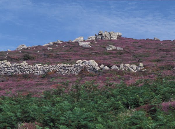
| Heather and Ruins on Tresco |
Shipwrecks, ancient ruins, fresh air, and an easy day’s journey from London–it sounded like the perfect vacation spot. Better yet, it seemed that no one we knew had heard of the Isles of Scilly. “Isn’t that somewhere in the Indian Ocean?” they asked. “You’re thinking of the Seychelles.” Or, “Isn’t that off the coast of Scotland?” “Nope, those are the Shetlands.” One friend was sure we were going to Sicily and had simply misspelled the name. We assured her that the Scilly Isles are not in Italy, but off the southwest coast of England. Scilly, which is pronounced “silly” as in “how silly of me,” has its origins in Roman times and comes from “sulli” meaning the “sun isles.” To get there today one can either fly or take the daily ferry from Penzance, in Cornwall.
Land, Sea and Mist
 |
| St. Mary's |
So, on a foggy morning in August, my husband and I boarded the Scillonian III ferry at the pier in Penzance and headed west into the Atlantic. Our fellow passengers included island residents returning home from the mainland, day trippers, and vacationers like us. About two hours later, we spied a cluster of small islands and islets emerging above the waves. As we approached the harbor, the mist cleared and the islands indeed became sun bathed, rising as scattered rocky outposts in a sparkling sea.
The twenty-eight mile trip had been unusually smooth, a fact I appreciated even more when I later learned that the ocean bottom around the islands is littered with hundreds of shipwrecks, victims of stormier days and the treacherous rocks that lurk beneath the surface. We docked at the quay in St. Mary’s, the largest and most populated of the Scilly Isles and the center of island life. We collected our luggage, which was piled next to beer kegs, building materials, groceries, and all the other supplies that have to be brought over daily from the mainland, and found a taxi. It took us to Eastbank, our bed and breakfast accommodation, just a short distance away on one of the island’s many small bays, with a view of the sea in one direction and a nature preserve and flower fields in the other. After meeting our gracious hosts, Linda and Melville Roberts, and settling ourselves in our large, tastefully decorated room, we set off to explore Hugh Town, the commercial center of St. Mary’s, where we purchased picnic food for lunch and visited the tourist office for maps and information on local activities. With a perimeter of only nine miles and a maximum width of three miles, everything on St. Mary’s is in easy walking distance. You can also rent bikes or use a local bus service.
A Mild Climate
 |
| Cromwell's Castle, Tresco |
About 2000 people live year round in the Scilly Isles, most of them on St. Mary’s. Five of the islands are inhabited–St. Mary’s, St. Agnes, St. Martins, Bryher and Tresco–and several others have ruins of previous habitation. Frequent boat service connects them. One day we took a trip to Samson, one of the uninhabited, or as the boatman joked, one of the uninhibited, islands, to see birds, seals and some of the many prehistoric ruins that litter the isles. Another day we took a boat to Tresco to see the famous Abbey Gardens, built by Augustus Smith, the 19th century Lord Protector of the isles, in the ruins of a medieval Abbey and now operated by the National Trust. Helicopter service from the mainland brings people daily to see the rare succulents, palms, eucalyptus, and other plants grown nowhere else in the British Isles. Warm ocean currents of the Gulf Stream bathe the Scilly Isles and moderate the climate. Despite a latitude equivalent to Vancouver or Frankfurt, the temperature rarely goes below freezing. The ancient stone walls and thick hedges act as windbreaks and create the microclimates that allow the plants to thrive. Other garden attractions include a stone altar, a remnant from the first century Roman occupation of the Scillies, a museum of figureheads rescued from sunken ships, and a lavish mural made of multicolored seashells.
 |
| Detail of decorative panel in Abbey Gardens at Tresco |
A Long History
From the original Bronze Age settlers, who farmed and fished on the islands, to the royalists who fled there during the English Civil War of the mid 1600's, and whose descendants are among the present inhabitants, the Scilly Isles have had continuous human occupation for more than four thousand years. One of the best ways to get an overview of the geologic, human, and natural history of the Scilly Isles is at the museum in Hugh Town where you can see maps, stone axe heads and other prehistoric artifacts, legal documents written in flowery script, historic photographs, seafaring and shipwreck souvenirs, mounted specimens of birds and flowers, pictures of the Queen’s millennium visit, and more.
The scattered granite outcrops that form the Scilly Isles today are actually the tops of larger hills that were once part of a single land mass, but as the oceans rose at the end of the last Ice Age, the low spots gradually became inundated until the hills became islands. The present shoreline was reached about seven hundred years ago. At an extremely low spring tide in the 1970's, someone walked a circle between all the islands just to prove that they were still almost joined. The channels between the islands are so shallow that many become sandbars at low tide; in some places, just under the surface of the water, you can see the tops of stone fences that are the boundaries of now submerged prehistoric fields. Uncultivated parts of the islands are mostly covered with bracken and heather. On our visit, the heather was in full bloom, giving the hillsides a brilliant magenta glow.
 |
| Bant's Carn (Neolithic Entrance Grave) |
On our first full day I joined a walking tour with Katherine Sawyer, a local expert in archaeology and Scilly history, who took us to see Bant’s Carn, a four thousand year old entrance grave on the west side of St. Mary’s. We also visited some prehistoric standing stones, the ruins of an ancient village, and the telegraph tower where Marconi did some of his early radio experiments. As we walked around the perimeter of the island we had to watch out for the shallow stone pits, remains of kelp burning in the nineteenth century. About three feet wide and two feet deep, these stone lined depressions were used as cauldrons for burning sea weed, which was gathered at low tide. The residue was then exported to the mainland for glass making. It was a laborious task, requiring more than twenty tons of kelp to produce one ton of finished product. It reminded me of a youthful experiment in making maple sugar which required boiling forty gallons of sap to get one gallon of syrup! At least the maple sugar smelled sweet as it cooked. Apparently the kelp burning produced a smelly, smoky pall that hung over the islands for the entire summer!
Part II will have more about what we did, what we ate, and what we saw during our relaxing week in the Scillies.
Click here for
MAPS and TOURIST INFORMATION.