Showing posts with label Marin. Show all posts

Monday, June 28, 2021

WEEKEND ESCAPE at INVERNESS and POINT REYES NATIONAL SEASHORE, CA, Guest Post by Matt Arnold

 52 Places to Go: Week 26

Point Reyes National Seashore, California

In June 2018, taking advantage of their daughter being away at camp, my son Matt and his wife Kate escaped their busy life in Oakland, CA, for a short road trip to explore Inverness and the area around Point Reyes.  Here is Matt's report along with his excellent photos.

 
Surprisingly close to the Bay Area, you feel a world away in the coastal town of Inverness, entering a part of California that seems from another era. Just the drive to the coast is worth the trip. After leaving the East Bay, we utilized the Nicasio Valley Road route.  Other scenic options include taking Sir Francis Drake Blvd through San Rafael or going through Mill Valley and Stinson beach via Highway 1.

Once leaving the outskirts of San Rafael and turning off of the 101, you are immediately thrown into a series of alternating quintessential California landscapes--from rolling golden hills dotted with Oak trees, to windy roads dodging giant Redwoods, to coastal bluffs filled with scrub brush, to pastoral grazing lands for cattle. The long and windy road feels less long, surrounded by such serenity. 
Looking East across Tomales Bay from "downtown" Inverness
We stayed, via Air B & B, at a small studio in the heart of Inverness, one block from Tomales Bay and Chicken Ranch Beach, looking eastward across Tomales Bay.
The topography of the area is defined by the San Andreas fault, and the collision of the Pacific and North American tectonic plates that slice their way through the Pacific edge of California. The fault line runs from Bolinas and Stinson beach to the south, following Highway 1 and then diving back into the water, forming the large and narrow Tomales Bay (think Baja California but upside down.)
Forster's Terns at Abbott's Lagoon
To the west of this fault line is Point Reyes National Seashore. Here, there is a vast collection of trails leading across the ridge with pine and oak forests, down to wild bluffs, abandoned beaches, rugged coastline, and a series of tranquil lagoons and marshland, with extensive tidal flats. There is a series of roads that lead to several of these locations, though trail heads will take you quite quickly away from the busier outlooks.
Looking across Tomales Bay from Tomales Bay State Park
The towns of Inverness and nearby Point Reyes Station, personify what would best be termed the West Marin (County) aesthetic. There is a touch of what might be blamed on the hippie roots of the area, and words like free, organic, artistic--attached to the lansdcape--all seeming appropriate. On a gastronomic level, this area is the intersection of the foodie culture that originated in the Bay Area, (fresh/locally sourced/organic) and the bucolic Old Califronia (where this produce is actually grown). Many brands, which are familiar to Bay area foodies (Marin Sun Farms, Cowgirl Creamery, Nicasio Valley Cheese, Strauss Creamery, Tomales Bay Oysters, etc.) are all located in the surrounding pasture lands/tidal zones, with several outlets in Point Reyes Station to sample their wares. In addition, the restaurants all serve top notch foodie fare, with oysters on the half shell at even the smallest sandwich shops. It is really hard to eat a meal here that isn't absolutely delicious.
There are still a few working farms on the land, and cows grazing, harking back to a true California of old.
The town of Inverness sits right at the edge of the more wild Point Reyes National Seashore, and after you round the bend on Sir Francis Drake Blvd and leave town, you really feel like you are leaving much of civilization behind. The scenery can be breathtaking. Most of the land is wild, with amazing vistas stretching from the hills down to the tidal flats or cliffs on the coast.
Tidal flats photographed in black and white at Drake's Estuary
On our particular trip, after a good night's sleep Friday, we woke early on Saturday morning and set out to explore (via our ritual exercise) the trail system in Point Reyes. We picked up coffee and breakfast at the IP Market (short for Inverness Park), which offers an excellent deli/cafe bar in addition to normal market supplies. Lots of fresh baked goods, and options for sandwiches (later I had their amazing Tri-Tip sandwich). We went to Bear Valley trailhead where Kate took off on her Saturday run, with the trail gently climbing and then descending to the coast, where several trail options will get you to the beach. Here you can get to waterfalls that flow directly into the Pacific (I think called Tidal Falls). 
Several trails in Point Reyes allow bike riding.
While Kate ran, I took off on a bike ride. The trail riding is a little more limited, and many of the trails only allow bikes on certain portions (only half of the Bear Creek trail is open.) After consulting a map I tried to string a few of the trails together, needing to use a few park roads to skip between trails, but ended up with a very satisfying ride, with the trails almost all to myself for several hours.
After our respective exercise regimens were checked off the to-do list on some pretty cool trails, we headed back to our studio. Sandwiches were picked up at the IP market and we were able to enjoy these at Chicken Ranch Beach (did I mention the Tri Tip?) 
Even in mid-June there were still plenty of wildflowers in bloom.
After lunch, another trip into Point Reyes Seashore to explore more hiking trails took me to a short trail to Abbott's lagoon.This was recommended by our AirB & B host and it did not disappoint.
Wildflowers were in bloom on the trail down to the lagoon plus an impressive collection of birds; others on the trail had just seen river otters in the lagoon (though I missed out.)
Sand dunes await at the mouth of  Abbott's lagoon, which then stretch onto the actual coastline and Point Reyes Beach.
This is a great trail to see seabirds that dot the shores around the lagoon. Once at the actual ocean front, one could potentially walk up and down the sandy beach for miles.
Dinner that night was in Inverness at the Salt Water Oyster depot. Despite being at the edge of civilization, the food was excellent. We enjoyed the local oysters, as well as scallops, and clams (linguini) and shrimp (cassoulet). When in Rome...
Sunday morning arrived sooner than we would have wished, and after cleaning up and checking out, we had one last dive into the National Seashore trail system, this time at the Estero trail head to a system of trails (most of them bike-able) surrounding Drake's Estero. This offered more views of the tidal estuary along mostly brush covered coastline.
On the Estero trail we caught several white tail deer and their fawns as it was "fawn season".
Despite the decent weekend weather, and relative proximity to San Francisco, being in the park never felt crowded. Though Bear Valley Visitor Center does get busy (it is the closest trail head to SF), we were there early, and almost every other trail that we explored we had mostly to ourselves. There were miles of some trails where I did not see another soul. This sense of isolation, so close to home, was wonderfully refreshing.
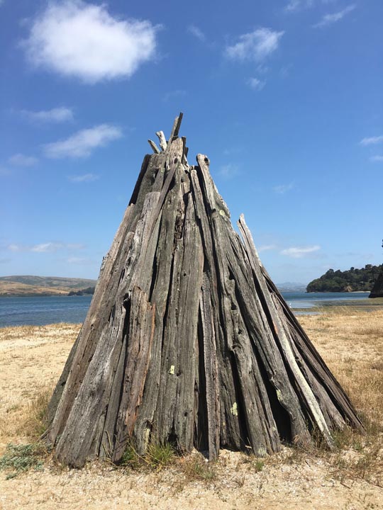
A short hike at Tomales Bay State Park to Indian Beach led to several reproductions of cone shaped Miwok bark shelters as part of a cultural exhibit.
On the way out of the National Seashore, we had one more stop on the beach, this time hitting Tomales Bay State Park, carved into the western edge of the bay, taking a short hike from Hearts Desire Beach (which was full of picnickers, kayakers, and BBQ) to Indian Beach.
An unusual thistle like plant along the trail to Abbott's Lagoon
Unfortunately our weekend was coming to an end. Reversing course on Sir Francis Drake Blvd brought us back through Point Reyes Station where we stopped for lunch. Again, we ate well, as the comfort food prepared at Side Street Kitchen was simply amazing (oysters, pork Belly BLT, pulled pork sandwich, salad). We picked up some cheese to take home across the road at Cowgirl Creamery, and returned to civilization through Nicasio Valley back to Oakland.
Lupins along Drake's estuary along the Estero trail
Despite packing a lot into the weekend, we felt refreshed and recharged for the week ahead. It felt like we barely scratched the surface of Point Reyes National Seashore and Tomales Bay, and left wanting to return for more. In particular, the Tule Elk Preserve on the northern tip, on the way to Tomales point, as well as the more famous and picturesque lighthouse at the opposite end, are on the list of things to get to on our next visit, or even camp in the park. Another trip will have to be made to actually kayak on Tomales Bay (Blue Waters Kayak) as well.
With only a small amount of traffic leaving Oakland, it took us around 1 hour, 20 minutes to get from the Bay Area to Inverness and Point Reyes.  For a map of Point Reyes click HERE. I hope you enjoy this report and are able to experience this area of California for yourself.
Abandoned fishing boat providing the classic Inverness snapshot


This article was first published July 2, 2018.

All text and photos copyright Caroline Arnold.

Monday, May 3, 2021

MUIR WOODS: California's Tallest Trees by Caroline Arnold at The Intrepid Tourist

 52 Places to Go: Week 18

What is taller than the Statue of Liberty, weighs more than a big ship, and is the world’s tallest living thing?  Answer: the coast redwood tree.  Reaching heights of more than 350 feet, the coast redwood (Sequoia sempervirens) is taller than any other living plant. (The actual tallest tree, named Hyperion, in a remote forest in northern California, is 379.1 feet tall.)  The largest redwood trees, some of which began growing more than 2000 years ago,  are also some of Earth’s oldest living things.  One of the best places to see redwoods is in Muir Woods, a National Monument in Marin County, California, just a 45 minute drive from San Francisco.  Last December (2010), when we were in the Bay Area, we did an excursion to Muir Woods with our family.
I have been to Muir Woods many times, but I am always awed by the towering grandeur of the trees, which seem to go up, and up, and up, and are impossible to capture in a single photo.  The damp wintry weather on the day of our visit lent a forest primeval sense to the air.  And, despite the mass of cars in the parking lot, once we started walking on the trails marked through the park, it did not seem crowded by people.
Muir Woods is home not only to redwoods, but a wide variety of other plants and wildlife.  On the day we visited, everyone was excited because, for the first time in several years, the salmon had returned to the creek to spawn.  (Once hatched, salmon spend their adult life in the ocean, only returning to their home creek to mate and lay eggs.)  As we stood on the bridge over Muir Creek and gazed into the shallow water, we could see the slippery fish churning their way upstream. 
You have to look closely to see the salmon in the water
Entrance fees: The entrance fee to enter the park is $5 for adults and free for children under 15.  However, a number of days in the year are free.  Or, if you have a National Park Pass, as I do, everyone in your group is free.

Getting there:  Muir Woods is located 11 miles north of the Golden Gate Bridge. Take Highway 101 to the Highway 1/ Stinson Beach Exit. Follow the signs to Muir Woods. Roads to the park are steep and winding. Vehicles over 35 feet long are prohibited. Parking space is very limited and fills quickly on most days. There are no RV parking facilities. For an interactive map, please visit http://maps.google.com/maps and type in Muir Woods National Monument. (My advice:  On weekends and in summer, you may have to park up to a half a mile away, so it is best to drop off your passengers at the entrance so everyone doesn't have to walk from where you park your car.) Note: check ahead to find out about Covid restrictions.

Book about the redwoods: For a wonderful children’s book about redwood trees, packed with facts and illustrated with an imaginative twist, go to Redwoods by Jason Chin.

All text and photos copyright Caroline Arnold
www.theintrepidtourist.blogspot.com


Monday, July 2, 2018

WEEKEND ESCAPE at INVERNESS and POINT REYES NATIONAL SEASHORE, CA, Guest Post by Matt Arnold

Point Reyes National Seashore, California
Two weeks ago, taking advantage of their daughter being away at camp, my son Matt and his wife Kate escaped their busy life in Oakland, CA, for a short road trip to explore Inverness and the area around Point Reyes.  Here is Matt's report along with his excellent photos.
Surprisingly close to the Bay Area, you feel a world away in the coastal town of Inverness, entering a part of California that seems from another era. Just the drive to the coast is worth the trip. After leaving the East Bay, we utilized the Nicasio Valley Road route.  Other scenic options include taking Sir Francis Drake Blvd through San Rafael or going through Mill Valley and Stinson beach via Highway 1.
Once leaving the outskirts of San Rafael and turning off of the 101, you are immediately thrown into a series of alternating quintessential California landscapes--from rolling golden hills dotted with Oak trees, to windy roads dodging giant Redwoods, to coastal bluffs filled with scrub brush, to pastoral grazing lands for cattle. The long and windy road feels less long, surrounded by such serenity. 
Looking East across Tomales Bay from "downtown" Inverness
We stayed, via Air B & B, at a small studio in the heart of Inverness, one block from Tomales Bay and Chicken Ranch Beach, looking eastward across Tomales Bay.
The topography of the area is defined by the San Andreas fault, and the collision of the Pacific and North American tectonic plates that slice their way through the Pacific edge of California. The fault line runs from Bolinas and Stinson beach to the south, following Highway 1 and then diving back into the water, forming the large and narrow Tomales Bay (think Baja California but upside down.)
Forster's Terns at Abbott's Lagoon
To the west of this fault line is Point Reyes National Seashore. Here, there is a vast collection of trails leading across the ridge with pine and oak forests, down to wild bluffs, abandoned beaches, rugged coastline, and a series of tranquil lagoons and marshland, with extensive tidal flats. There is a series of roads that lead to several of these locations, though trail heads will take you quite quickly away from the busier outlooks.
Looking across Tomales Bay from Tomales Bay State Park
The towns of Inverness and nearby Point Reyes Station, personify what would best be termed the West Marin (County) aesthetic. There is a touch of what might be blamed on the hippie roots of the area, and words like free, organic, artistic--attached to the lansdcape--all seeming appropriate. On a gastronomic level, this area is the intersection of the foodie culture that originated in the Bay Area, (fresh/locally sourced/organic) and the bucolic Old Califronia (where this produce is actually grown). Many brands, which are familiar to Bay area foodies (Marin Sun Farms, Cowgirl Creamery, Nicasio Valley Cheese, Strauss Creamery, Tomales Bay Oysters, etc.) are all located in the surrounding pasture lands/tidal zones, with several outlets in Point Reyes Station to sample their wares. In addition, the restaurants all serve top notch foodie fare, with oysters on the half shell at even the smallest sandwich shops. It is really hard to eat a meal here that isn't absolutely delicious.
There are still a few working farms on the land, and cows grazing, harking back to a true California of old.
The town of Inverness sits right at the edge of the more wild Point Reyes National Seashore, and after you round the bend on Sir Francis Drake Blvd and leave town, you really feel like you are leaving much of civilization behind. The scenery can be breathtaking. Most of the land is wild, with amazing vistas stretching from the hills down to the tidal flats or cliffs on the coast.
Tidal flats photographed in black and white at Drake's Estuary
On our particular trip, after a good night's sleep Friday, we woke early on Saturday morning and set out to explore (via our ritual exercise) the trail system in Point Reyes. We picked up coffee and breakfast at the IP Market (short for Inverness Park), which offers an excellent deli/cafe bar in addition to normal market supplies. Lots of fresh baked goods, and options for sandwiches (later I had their amazing Tri-Tip sandwich). We went to Bear Valley trailhead where Kate took off on her Saturday run, with the trail gently climbing and then descending to the coast, where several trail options will get you to the beach. Here you can get to waterfalls that flow directly into the Pacific (I think called Tidal Falls). 
Several trails in Point Reyes allow bike riding.
While Kate ran, I took off on a bike ride. The trail riding is a little more limited, and many of the trails only allow bikes on certain portions (only half of the Bear Creek trail is open.) After consulting a map I tried to string a few of the trails together, needing to use a few park roads to skip between trails, but ended up with a very satisfying ride, with the trails almost all to myself for several hours.
After our respective exercise regimens were checked off the to-do list on some pretty cool trails, we headed back to our studio. Sandwiches were picked up at the IP market and we were able to enjoy these at Chicken Ranch Beach (did I mention the Tri Tip?) 
Even in mid-June there were still plenty of wildflowers in bloom.
After lunch, another trip into Point Reyes Seashore to explore more hiking trails took me to a short trail to Abbott's lagoon.This was recommended by our AirB & B host and it did not disappoint.
Wildflowers were in bloom on the trail down to the lagoon plus an impressive collection of birds; others on the trail had just seen river otters in the lagoon (though I missed out.)
Sand dunes await at the mouth of  Abbott's lagoon, which then stretch onto the actual coastline and Point Reyes Beach.
This is a great trail to see seabirds that dot the shores around the lagoon. Once at the actual ocean front, one could potentially walk up and down the sandy beach for miles.
Dinner that night was in Inverness at the Salt Water Oyster depot. Despite being at the edge of civilization, the food was excellent. We enjoyed the local oysters, as well as scallops, and clams (linguini) and shrimp (cassoulet). When in Rome...
Sunday morning arrived sooner than we would have wished, and after cleaning up and checking out, we had one last dive into the National Seashore trail system, this time at the Estero trail head to a system of trails (most of them bike-able) surrounding Drake's Estero. This offered more views of the tidal estuary along mostly brush covered coastline.
On the Estero trail we caught several white tail deer and their fawns as it was "fawn season".
Despite the decent weekend weather, and relative proximity to San Francisco, being in the park never felt crowded. Though Bear Valley Visitor Center does get busy (it is the closest trail head to SF), we were there early, and almost every other trail that we explored we had mostly to ourselves. There were miles of some trails where I did not see another soul. This sense of isolation, so close to home, was wonderfully refreshing.
A short hike at Tomales Bay State Park to Indian Beach led to several reproductions of cone shaped Miwok bark shelters as part of a cultural exhibit.
On the way out of the National Seashore, we had one more stop on the beach, this time hitting Tomales Bay State Park, carved into the western edge of the bay, taking a short hike from Hearts Desire Beach (which was full of picnickers, kayakers, and BBQ) to Indian Beach.
An unusual thistle like plant along the trail to Abbott's Lagoon
Unfortunately our weekend was coming to an end. Reversing course on Sir Francis Drake Blvd brought us back through Point Reyes Station where we stopped for lunch. Again, we ate well, as the comfort food prepared at Side Street Kitchen was simply amazing (oysters, pork Belly BLT, pulled pork sandwich, salad). We picked up some cheese to take home across the road at Cowgirl Creamery, and returned to civilization through Nicasio Valley back to Oakland.
Lupins along Drake's estuary along the Estero trail
Despite packing a lot into the weekend, we felt refreshed and recharged for the week ahead. It felt like we barely scratched the surface of Point Reyes National Seashore and Tomales Bay, and left wanting to return for more. In particular, the Tule Elk Preserve on the northern tip, on the way to Tomales point, as well as the more famous and picturesque lighthouse at the opposite end, are on the list of things to get to on our next visit, or even camp in the park. Another trip will have to be made to actually kayak on Tomales Bay (Blue Waters Kayak) as well.
With only a small amount of traffic leaving Oakland, it took us around 1 hour, 20 minutes to get from the Bay Area to Inverness and Point Reyes.  For a map of Point Reyes click HERE. I hope you enjoy this report and are able to experience this area of California for yourself.
Abandoned fishing boat providing the classic Inverness snapshot


Monday, January 27, 2014

MARINE MAMMAL CENTER at the Marin Headlands,San Francisco Bay California

View from the Marine Mammal Center entrance on a foggy day.
Every year hundreds of sick and injured seals, sea lions, elephant seals, and sea otters wash up on northern California’s beaches.  If they are lucky, they are found and taken to the Marine Mammal Center on the Marin Headlands where they receive food, medical care, and when they are well enough to be on their own, are returned to the wild. Located on a hillside above the lagoon, the center is open to the public.  On a recent foggy Sunday afternoon I stopped by for a visit.

Life-size Elephant Seal Statue

The entrance to the Marine Mammal Center features life-size statues of a sea lion, elephant seal and sea otter who greet visitors, allowing one to gain an appreciation of how big these animals are and to see them up close--an opportunity one would never have with a live animal.


California sea lion resting next to the pool in its enclosure
Inside the facility a stairway (or elevator) leads to a second floor viewing platform which looks out over the outdoor enclosures where the animals are kept.  Signs caution visitors to be quiet so as not to disturb the animals.  During our visit, in mid-August, not all the enclosures were occupied, but during the pupping season in spring, when young animals get lost and separated from their mothers, the enclosures are full.  A volunteer told us that during the peak period last spring they had hundreds of animals, requiring round the clock feeding.

Whale baleen
The Marine Mammal Center is both a treatment center and an educational center.  Exhibits explain how animals are rescued,what kind of medical treatments they get, the process of reintroducing them to the wild, and the importance of keeping the ocean clean--and the danger to animals of trash, nets, and water pollution.  There are also numerous hands-on exhibits--feeling the softness of sealskin, for instance--as well as displays of animal skeletons, giant whale vertebrae and an example of whale baleen.
The Marin Headlands is located  north of San Francisco, just on the other side of the Golden Gate Bridge.  On the road to the Marine Mammal Center one has a dramatic view of the city and of the bridge. 
The Marine Mammal Center is open to the public daily from 10 a.m. to 5 p.m., except Thanksgiving, Christmas and New Year's Day. Admission is free and no reservation is required unless you have a group of 10 or more people. A well-stocked gift shop, which supports the Center, has books and ocean themed toys, shirts, and decorative objects.  The Center relies on donations for its funding. For more information about the Marine Mammal Center click here.

Monday, December 26, 2011

Muir Woods: California's Tallest Trees

 What is taller than the Statue of Liberty, weighs more than a big ship, and is the world’s tallest living thing?  The answer: the coast redwood tree.  Reaching heights of more than 350 feet, the coast redwood (Sequoia sempervirens) is taller than any other living plant. (The actual tallest tree, named Hyperion, in a remote forest in northern California, is 379.1 feet tall.)  The largest redwood trees, some of which began growing more than 2000 years ago,  are also some of Earth’s oldest living things.  One of the best places to see redwoods is in Muir Woods, a National Monument in Marin County, California, just a 45 minute drive from San Francisco.  Last December (2010), when we were in the Bay Area, we did an excursion to Muir Woods with our family.
I have been to Muir Woods many times, but I am always awed by the towering grandeur of the trees, which seem to go up, and up, and up, and are impossible to capture in a single photo.  The damp wintry weather on the day of our visit lent a forest primeval sense to the air.  And, despite the mass of cars in the parking lot, once we started walking on the trails marked through the park, it did not seem crowded by people.
Muir Woods is home not only to redwoods, but a wide variety of other plants and wildlife.  On the day we visited, everyone was excited because, for the first time in several years, the salmon had returned to the creek to spawn.  (Once hatched, salmon spend their adult life in the ocean, only returning to their home creek to mate and lay eggs.)  As we stood on the bridge over Muir Creek and gazed into the shallow water, we could see the slippery fish churning their way upstream. 
You have to look closely to see the salmon in the water
Entrance fees: The entrance fee to enter the park is $5 for adults and free for children under 15.  However, a number of days in the year are free.  Or, if you have a National Park Pass, as I do, everyone in your group is free.

Getting there:  Muir Woods is located 11 miles north of the Golden Gate Bridge. Take Highway 101 to the Highway 1/ Stinson Beach Exit. Follow the signs to Muir Woods. Roads to the park are steep and winding. Vehicles over 35 feet long are prohibited. Parking space is very limited and fills quickly on most days. There are no RV parking facilities. For an interactive map, please visit http://maps.google.com/maps and type in Muir Woods National Monument. (My advice:  On weekends and in summer, you may have to park up to a half a mile away, so it is best to drop off your passengers at the entrance so everyone doesn't have to walk from where you park your car.)

Book about the redwoods: For a wonderful children’s book about redwood trees, packed full of facts and illustrated with an imaginative twist, go to Redwoods by Jason Chin.