Showing posts with label tour. Show all posts

Monday, July 10, 2023

NAMIBIA: Spectacular Dunes and Abundant Wildlife, Part II, Guest Post by Owen Floody.

Zebra at Etosha National Park, Namibia.

With many thanks to our friend Owen Floody, who was my husband's field partner on our trip to East Africa in 1971. Art and I have not been back to Africa since then, but Owen has made numerous trips in recent years and written about several of them for The Intrepid Tourist. His latest report chronicles a trip to Namibia—his third—and is accompanied by his excellent photographs.

Where the Namib desert meets the sea.

My previous post began with my description of a recent photo-tour of Namibia and 
ended as we flew by small plane from the red sand dunes of Sossusvlei to coastal Swakopmund, marking the tour’s transition from an emphasis on landscapes to one on wildlife. The flight itself provided a second look at the shapes and distributions of the Sossusvlei dunes. Particularly impressive was how abruptly the dunes end and the ocean begins. In addition, the flight permitted us to look down on one of the shipwrecks that give the Skeleton Coast its name. Finally, we viewed an impressive bank of mist extending inland from the ocean, as is very typical of this area.

These mists limited our activities in the Swakopmund area. One victim was a planned excursion to Walvis Bay in search of flamingos and other water birds. But we did see quite a few flamingos from the plane.  And the mists could not completely derail a Living Desert tour that exposed us to a few of the small creatures (chameleons, geckos, skinks, and spiders) able to make the dunes their home.

Gecko.

From Swakopmund, we continued on to our last two stops, Etosha National Park (in northern Namibia) and the Erindi Private Game Reserve (about midway between Etosha and Windhoek, our endpoint).
  Even though we saw wildlife earlier in the tour, these were the areas that we expected to be the most wildlife rich.

The Etosha Salt Pan.

Etosha is the third largest of African national parks at 8600 sq mi, closely approaching the size of New Hampshire. Contained almost entirely within it is the Etosha Pan, a salt pan of about 1840 square miles. Etosha is dry, though average rainfall levels vary seasonally and regionally.
  Due to its aridity, much of the wildlife viewing in Etosha occurs at waterholes, some natural, others man-made.  A few of these (including one a few feet from my room) are lit at night, permitting interesting views of a great variety of animals as they (very cautiously) visit to drink.

Giraffes and rhinos at the water hole.

Of the waterhole visitors, zebra are so photogenic as to be hard to beat.
 Nevertheless, the most prized nighttime visitors were the black rhinoceros and giraffes: I did not expect to see this many rhinos and was very pleased by the turnout.  And nothing could have beat the show put on for us by a large herd of elephants during a daytime waterhole visit. All of them, but especially one expressive and irresistible baby, had a grand time frolicking in the dust, water and mud.

Mother elephant and her calf having a mud bath.

Even though these sightings were great and made our visit to Etosha memorable, sightings of some other animals, especially big cats, were scarce. It was suggested that this reflected eastward movements of some animals in response to conditions that were unusually arid even by Etosha's standards.

Mother cheetah and her cubs.

We hoped that these gaps would be filled at Erindi.  And, to some extent, they were, as we were able to get good views of cheetah (6th image) and lions there. Unfortunately, at least some of these sightings came at what I considered unacceptable costs.  One of the benefits of private reserves is the ability to drive off road and at night.  And done judiciously, I think that these can be valuable.  However, our efforts to track a hunting mother cheetah suggested to me that the drivers at Erindi (which were not those attached to our tour) were prone to engage in two unethical practices.  First, they frequently plowed right through any shrub or small tree that might otherwise have required a detour. Secondly, several vehicles maintained positions close to and on at least three sides of the hunting cat. It is hard for me to believe that these intrusions didn’t compromise the hunt (which did end unsuccessfully). One of the drivers claimed that he knows the animals individually and well and would have broken off the pursuit if the animal was distressed. Perhaps this is true, but I am unconvinced. Since many of the cats are radio-collared, it should be possible to collect data on the outcome of hunts accompanied and unaccompanied by safari vehicles. If the success rates are similar, I will praise the sensitivity and skill of the drivers. Otherwise, I will give Erindi a pass, as I did on our remaining game drive.

Please bear in mind that this incident occupied no more than two hours of a 17-day trip.  Therefore, anyone attracted to Namibia but concerned about the incident should recall the saying about throwing out the baby along with the bathwater. Taken together, the sights and experiences of this trip for me elevate further a destination that already was one of my favorites. In my opinion, tweaking the itinerary would be an appropriate response, staying away would be overkill and unnecessary.      

Part I of Owen’s report appeared on July 3, 2023.

Monday, July 3, 2023

NAMIBIA: Spectacular Dunes and Abundant Wildlife, Part I, Guest Post by Owen Floody.

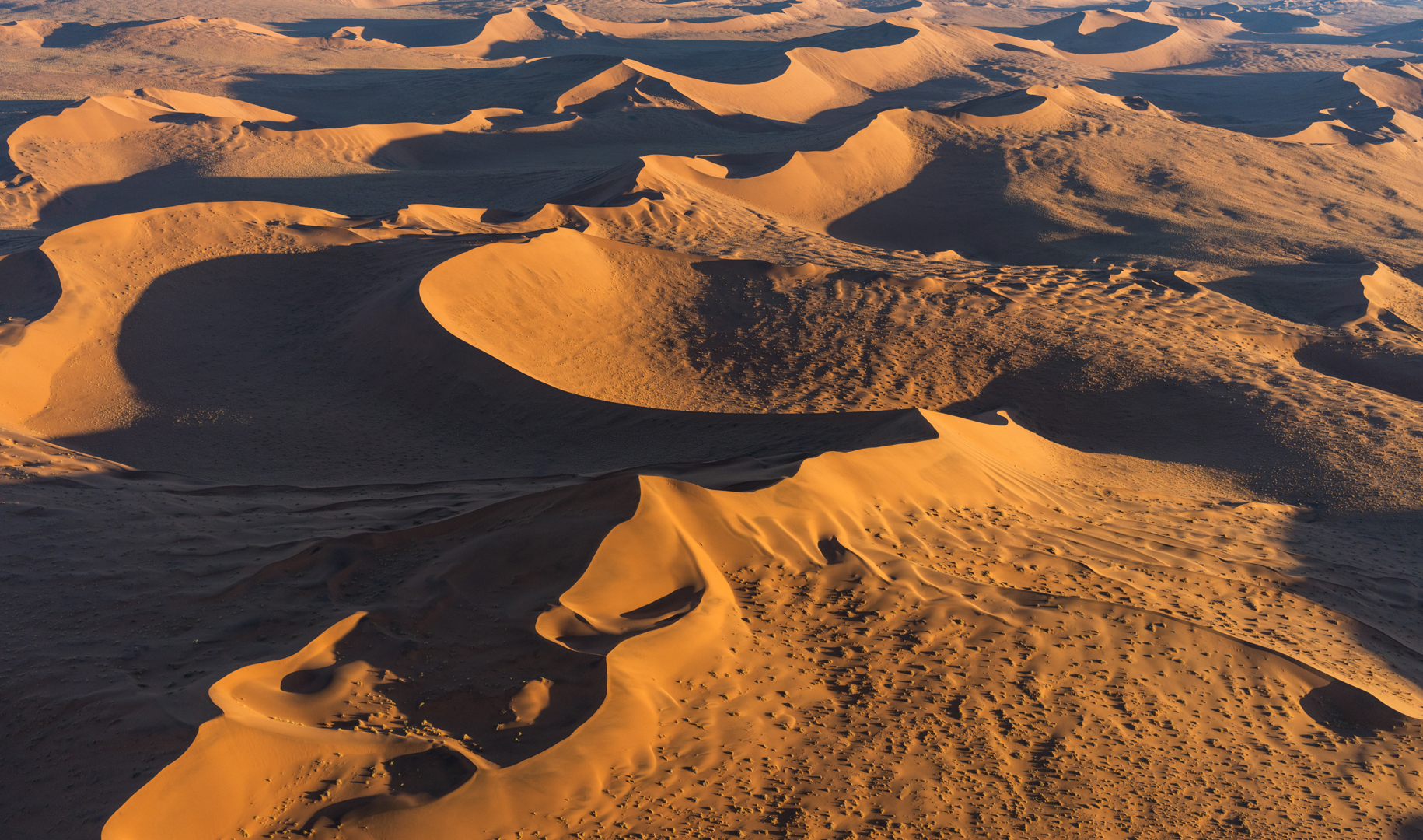
Namib Desert, view from the air.

With many thanks to our friend Owen Floody, who was my husband's field partner on our trip to East Africa in 1971. Art and I have not been back to Africa since then, but Owen has made numerous trips in recent years and written about several of them for The Intrepid Tourist. His latest report chronicles a trip to Namibia—his third—and is accompanied by his excellent photographs.

I recently returned from a 17-day photo-tour of Namibia, in southern Africa.  This was run by Joseph van Os Photo Tours and led by Mike Byrne.  Mike was a great organizer, leader and photographic mentor, whose efforts were enhanced by our expert Driver/Guides Jakes De Jager and Charl Schoombee, of the Swakopmund-based SafariWise. This was my third visit to Namibia. I have enjoyed them all, but this was the best, primarily because its itinerary was loaded with photographic must-sees.

Namibia is a moderately large country, about twice the size of California. It gained its independence just in 1990. It is the most arid country in sub-Saharan Africa and, not surprisingly, is very sparsely populated: Only Mongolia has a lower population density.  Nevertheless, it is blessed by striking landscapes and abundant wildlife. It was the goal of this tour to present both of these, with landscapes dominating the first half and wildlife the second.  My report will reflect this division, with the first installment focusing on landscapes followed by a second emphasizing wildlife.

Quiver trees.

The trip began with a long drive from Namibia’s capital, Windhoek, to a farm near Keetmanshoop.
  This farm and area are notable for a concentration of grotesquely beautiful Quiver Trees.  It was our hope to photograph these in the late afternoon, at sunset, against the Milky Way, and at sunrise.  However, a nearly full moon forced us to give up on the Milky Way and focus instead on the other conditions and a different expanse of the night sky. As expected, the quiver trees were lovely, especially in the golden light of sunset and sunrise.

Abandoned house in Kolmanskop.

Next, we spent two days poking through and around Kolmanskop, a town that rose with the discovery of diamonds and crashed with their exhaustion.  It has been abandoned and besieged by the sands since the 1950s. Though not familiar generally, it is well-known among photographers for the striking images it offers suggesting decay and the power of natural forces.  However, I found it to present two faces. The predominant one is of rooms and buildings being gradually reclaimed by sand.  

Building in Kolmanskop, an abandoned diamond mining town.

Contrasting with these are a few other buildings and rooms that look as though you could move in tomorrow: Even though decay may be the dominant theme, some scenes speak more of resistance and resilience.

Dead Vlei salt pan.

Our next stop was Sossusvlei, the expanse of orange and red sand dunes that is Namibia’s greatest claim to fame. We had a wonderful morning wandering around Dead Vlei, a salt and clay pan packed with dead trees, some of which are thought to have died more than 500 years ago.
  For me, the comparison to a modern dance troupe was irresistible.  

Sossusvlei.

In addition, we gaped at the surrounding fantastically shaped dunes.
 One of these is Big Daddy, a particularly tall (roughly 900 ft) dune with a commanding view. Big Daddy often is recognizable from the groups of people laboriously climbing its spine. 

"Big Daddy" sand dune.

In these explorations, we benefited from our tour’s ability to book us into the Dead Valley Lodge, one of a very few lodges located within the national park’s boundaries.
  Whereas most visitors were held at the park gates until sunrise, we were able to get a valuable earlier start.

View from the air.

Some aspects of the Sossusvlei dunes are best appreciated from the ground.
  However, such views cannot convey a sense of the extent of the dune field. The Namib Desert is large, extending 30-100 mi inland from the Atlantic Ocean and over 1000 mi along the coasts of Namibia and neighboring countries.  We were extremely fortunate to have two opportunities to see this desert from the air. First, most of us took optional helicopter rides over the dune field. Second, when it became time to leave Sossusvlei, we flew by small plane from there to Swakopmund, our next stop.

These views were wonderful and well worth the added expense. They reinforced our earlier impressions of the dunes’ remarkable shapes and textures. Both flights extended these impressions by revealing much more of the field’s huge size, with dunes marching off as far as the eye can see.

To be continued next week.


Monday, September 14, 2020

16 DAYS IN MOROCCO, Part 1: Guest Post by Tom and Susan Weisner

Chechaouen, "The Blue City", Morocco
Our friends Tom and Susan Weisner went on a 16 day tour of Morocco in June 2019 and have kindly agreed to share a few of their wonderful photos and memories of the trip. This is Part 1. Part 2 will post next week.

Our trip to Morocco was part of a group tour organized by Reed College, where Tom was a student in the 1960s. There were fifteen in our group, including Paul Silverstein, an anthropologist who teaches at Reed and who does fieldwork in Morocco. We had a great Moroccan guide too!

Rabat, Capital of Morocco
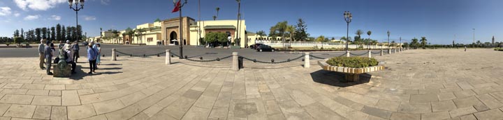
Palace near Rabat.
Morocco is a kingdom with some parliamentary government. This is the palace near Rabat. There are other palaces as well.
Rabat fort and inner city at night.
The tomb of Mohammad VI (former king) is in Rabat. Rabat has a huge market in old city walls with narrow streets.

Casablanca, the largest city in Morocco
Susan and Tom at the mosque in Casablanca.
King Hassan II built the second largest mosque in the world in Casablanca (Mecca is #1). It is marble, vast, on the Atlantic coast. Non-Muslims can only enter as part of an official tour.
Typical Moroccan dish.
A beautiful restaurant.
We enjoyed wonderful food! Tajines! (Tajine dishes are slow-cooked savory stews, typically made with sliced meat, poultry or fish together with vegetables or fruit.)
Synagogue
Hundreds of thousands of Jews once lived in Morocco, but most left during and after WWII, going to Israel, Europe and elsewhere. Morocco does not recognize Israel, but the Israeli passport is recognized since so many from the diaspora do sometimes return. We saw a number of museums and synagogues that are protected. Morocco is about the only Muslim Middle East country that has religious pluralism in the constitution.
Catholic church in Casablanca
There are thousands of black sub-Saharan African immigrants arriving in Morocco, trying to get to Europe. Many are Christian. This is a Catholic Church in Casablanca for them. A very rare sight.

Romans in Morocco: Volubilis, Ancient Roman City near Meknes
Roman ruin with mosaic floor.
The Romans, of course, settled all of North Africa including Morocco. We visited Volubilis near the city of Meknes, for example, an entire former Roman city with over 40K inhabitants.Volubilis is a World Heritage site.
Ancient Roman Empire included northern portions of Morocco.
Morocco is in the lower left corner of this map in red.

Tangiers
American National Historic Landmark in Tangiers.
A landmark to the American legation is inside the Medina, or interior market in Tangiers. It was the first American government office outside the US. It is also the site of a Paul Bowles museum.
View of Tangiers
Morocco gained independence from France in 1956 and Rabat became the new capital. replacing Tangiers as the capital city. You can see Tangiers city in white in the distance from our beautiful hotel on the Mediterranean. Spain is faintly visible on the far horizon just a few miles away across the Strait of Gibralter.

Chechaouen
Chefchaouen is a city in Morocco that's famous for its blue hue. While it was founded in 1471, it didn't get its distinctive color until 1492, when it received an influx of Jews escaping the Spanish inquisition, who brought a tradition of painting buildings blue.
Chechaouen, the Blue City, is between Tangiers and Meknes.  Beautiful! We saw many stalls and shops as we walked through the narrow alleys everywhere. Lunch and tea there.
Market stall in Chechaouen.
Purses, shoes and more!
Part 2 of 16 DAYS IN MOROCCO will post next week.


Monday, September 16, 2019

GETTING TO KNOW GREENLAND - PART 1: NARSARSUAQ Guest Post by Caroline Hatton


From the plane: the Greenland Ice Sheet, glaciers, and lakes with clear blue to milky beige waters.

My friend and fellow children’s book author Caroline Hatton and her husband Bill visited Greenland in July 2019. She took all the photos in this post.

Ever since I first saw Greenland from the air, as a teen tourist flying with my parents from home in Paris to New York, I’ve dreamed of visiting this world of snow and ice and mountains with unknown names. Half a century later, I decided to go to Greenland before global warming makes it “all melt away.” Considering the headlines about the June 2019 Greenland IceSheet record melting spike, I hoped July 2019 wasn’t “two weeks too late…”

What should we see and do? We found no tour books. Old Iceland tour books had only a paragraph about Greenland. With insufficient info online, choosing destinations was too hard.

What does the landscape look like? Are there hiking trails or maps? How many days should we spend in each place? In the end, my husband picked a packaged tour, a sampler combining a Viking archeological site, icebergs, the midnight sun, history, culture, cuisine, and free time for hiking. The package included flights to three towns, “one with a name that starts with an N,” Bill said, “the capital, and one that starts with an I,” my first clue that Greenlandic is a challenge.
Flying from Reykjavik, Iceland, to Narsarsuaq, Greenland. Image courtesy of NASA, with red added.
We flew 2 h 20 min from Reykjavik, Iceland, to Narsarsuaq in South Greenland.
Greenlandic Bluebells (Campanula gieseckiana ssp. groenlandica)
I found Greenland phenomenal because of the enormous size and fluorescent blooms of its Greenlandic Bluebells (Campanula gieseckiana ssp. groenlandica), the myriad shapes and shades of blue of its waters in fjords and glacial lagoons and icecap meltwater lakes, and… the ferocity of its mosquitoes.
Former World War II movie theater. Marlene Dietrich sang there in person.
Narsarsuaq is a former World War II U.S. military airbase. It was needed as a refueling stop for planes headed for battle in Europe. American soldiers wounded in Europe received care at the base hospital on their way home. The Narsarsuaq Museum tells the story with roomfuls of photographs, news articles, documents, correspondence, military and medical paraphernalia, and every-day objects. The runway and some original buildings still exist.
This is Narsarsuaq: a runway, a hotel, a supermarket, a museum, a one-room school, four places to eat, and a tiny harbor (not in photo)... Across the fjord, the current sheep farming settlement, Qassiarsuq, and Erik the Red’s Viking ruins.
A 15-minute boat ride across the fjord is the Viking archeological site of Erik the Red’s farm, Brattahlíð, which is part of a UNESCO World Heritage Site.
The most substantial Viking ruins at this site: the wall stones of a Christian church, inside a turf fence. Other stones are still aligned where house and barns once stood. Nearby replicas of a long house and of an earlier, minuscule church are open to visitors.
Erik the Red came from Iceland in 982 and later established a Norse colony in what he named Greenland to attract more settlers. South Greenland truly was and still is heavenly green.

After more than 400 years in Greenland, the Vikings abandoned their settlements, but not until after the Thule ancestors of modern Inuits had arrived. Then the area became uninhabited again for roughly 300 years, before sheep farming restarted and continued until now. This history is summarized by tour guides and at the Narsarsuaq Museum.
The only musk ox we saw was on an appetizer at the Hotel Narsarsuaq restaurant—dark, dried, and shredded atop raw scallops. Edible wildflowers were picked outside the hotel and kept fresh with crushed ice: a purple Greenlandic Bluebell (Campanula gieseckiana ssp. groenlandica), pink Dwarf Fireweed (Chamaenerion latifolium), and yellow Greenland Buttercups (Ranunculus auricomus).
Today, guides lead visitors on foot or by boat or helicopter, to the Inland Ice (Greenland Ice Sheet), glaciers, icebergs, viewpoints, nearby towns, villages, tiny settlements, or more Viking ruins. Seeing musk ox, a wild and woolly beast of the Arctic looking bovine but related to sheep, would have been cool. But we would have had to research where locals might have seen some, then hire a guide and a boat for a day… at a phenomenal cost.
Permanent nylon ropes helped us climb a rocky slope.
Instead, we took a photo of the trail map hanging in the hotel lobby and went hiking past the ruin of the World War II hospital, through Flower Valley, and up to one of several small lakes.
Kiattuut Sermiat, an average backyard glacier, as seen from the trail
We loved the exercise, the scenery, and our mosquito-net jackets and headwear. Taking each photo two or three times was enough to get one without mosquitoes parked on the camera lens, creating big blurry blotches.
At the Polar-Tut Café: imagine thumping music.
For dinner at the Polar-Tut Café, we ordered from the menu board, handwritten in English and Danish, the second language taught in school (because Greenland is a constituent country of the Kingdom of Denmark). Reje burger is Danish for shrimp burger, shrimp and fish being the top Greenlandic exports. Local Qajaq beer on tap came in three shades: Doppelbock, Pilsner, and Dunkel.

After three richly satisfying days in Narsarsuaq, we flew up the west coast to the capital, Nuuk (pronounced nuke). There are no roads between towns in Greenland, so people get around by boat or plane. Clear skies made flightseeing a highlight of our trip.

For more info
Extreme melting in Greenland is not the only problem due to climate change: huge Arctic wildfires burned there and in Siberia, Scandinavia, and Alaska.

A U.S. World War II veteran pilot’s dramatic personal account of flying through Narsarsuaq