Showing posts with label walk. Show all posts

Monday, January 29, 2024

RIVER WALK, HILLSBOROUGH, NC: Reliving History at Occaneechi Village

Historic replica of Occaneechi Village, Hillsborough, NC

In late November, on a cool but bright fall day, we took a walk along the Eno River in Hillsborough, North Carolina, with our family. The Riverwalk path follows the river bank through the town park and links with other hiking trails. Not far from where we joined the trail near the Weaver Street Market we came upon Occaneechi Village, a historic replica of a native American village as it would have been in 1701.

Thatched dwelling.

At that time the Occaneechi Band of the Saponi Nation lived on the land, growing food and hunting in the surrounding forest. The village was an important trade location where the Occaneechi people traded with Europeans as well as nearby tribes such as the Tuscarora. Many descendants of the Occaneechi tribe continue to live in Hillsborough.

Village surrounded by stockade of wooden posts.

Inside a stockade of wooden stakes are several thatched dwellings, open air shelters, places to build fires and prepare food, and other work areas.

Sample of caulking along the lower part of the stockade.

Openings between the wooden stakes could be filled with a lattice of sticks caulked with mud.

River Park path.

After exploring Occaneechi Village we continued walking along the paved path through River Park. 

Map of the Oxbow archeological site.

Signs further along the trail explained the historic significance of this location. 
Toward the end of our two mile walk we learned that archeological research of the ten-acre site within the oxbow bend of the Eno River has revealed that it was home to Occaneechi villages going back to 1000 A.D.

Footbridge across Eno River at Oxbow.

At the bridge near the oxbow, the trail veers away from the river bank and heads into the forest. We turned around here and headed back to our car. (A large parking garage is located near the trail head.) On our way back we passed a deer busy browsing, who paid little attention to us or other walkers.

Deer.

Occaneechi Village is located along the Riverwalk, within River Park, behind the Farmer’s Market Pavilion in Hillsborough. It is open 8am to 7pm. Hillsborough is about a half-hour drive from Chapel Hill, where our daughter and her family live.


Monday, May 15, 2023

A TRIP THROUGH TIME: HOODOOS AND FOSSILS in the Badlands of Alberta Canada

Hoodoos, near Drumheller, Alberta, Canada

Over the eons the Red Deer River has cut a valley into the Alberta plains in Western Canada, revealing layers of rock going back to dinosaur times. Wind and rain have carved some of these rocks into giant mushroom shapes called hoodoos when the upper layer of rock erodes more slowly than the layer beneath. 

Stairways lead to viewing platforms for the hoodoos.

In early May, my husband Art and I visited Alberta, getting a close look at some of the hoodoos and taking a self-guided geology walk near the Royal Tyrell Museum in Drumheller.

Alberta wheat fields.

To get to Drumheller we drove an hour and a half from Calgary across the Alberta wheat fields—an endless vista of golden plains dotted with the occasional silo or homestead. Then suddenly, just before arriving at the town of Drumheller, the road plunged down into the Red Deer River valley, almost as if the earth had suddenly cracked open to show us the history of its insides.

Each layer of rock is a story from the past. White sandstone was once sand at the bottom of a river. Grey-brown layers were once silt and mud. Black is coal, formed by the remains of plants. Chemical reactions in the buried sediments form the dark iron-stones.

The Red Deer River Valley was formed by floodwaters from melting glaciers during the last Ice Age, 10,000 to 15,000 years ago, and it has been eroding ever since.

Signs with history of the area are posted throughout the valley.

The black layers of the rock walls are coal. The coal mines that once drew people to this valley are no longer operating. Other layers are filled with dinosaur bones and other fossils of the Dinosaur Age. The fossil discoveries in Alberta have been spectacular and many are on display at the Royal Tyrell Museum in Drumheller. (The museum will be the subject of another blogpost.) 

A map of the trail and location of interpretive signs.

But just outside the museum is the Badlands Interpretive Trail, a one-kilometer loop walk that provides a close look at the local geology and information about the area--a good introduction or follow-up to visiting the museum.

Crocuses blooming along the trail are a sign of spring.

The climate of the Red Deer River in the late Cretaceous, 72 million years ago, was warm and moist, like Florida today. Today, the valley is seasonally warm and semi-arid. On the day we visited, in late May, the weather was cool and overcast, ideal for taking a walk.

Along the trail numbered signs explained what we were seeing.
These small boulders made of igneous rock were brought from elsewhere and dropped by a melting glacier.

Hoodoos like these on the museum trail are found throughout the badlands.

This fossilized tree stump from a giant redwood was part of a forest that once grew here.

Most of Alberta’s dinosaur remains are found in the Badlands and river valleys where Cretaceous-aged sediments are exposed. Today, wind, rainfall, and snow melt continue to erode the badlands, exposing more fossils with each passing season. We did not see any fossil remains on our walk, but we could imagine what the Earth was like millions of years ago when dinosaurs made Alberta their home.

Walking the dinosaur trail.


Monday, September 12, 2022

BUTTERFLY WALK: UC Botanical Garden, Berkeley, CA

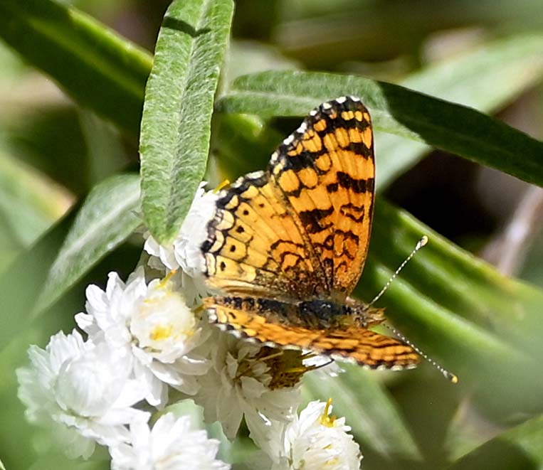
Mylitta Crescent butterfly at the UC Botanical Garden, Berkeley, CA

It is said that only mad dogs and Englishmen go out in the midday sun. Add to that list: butterfly enthusiasts. Butterflies like the sun—using it to heat their bodies—and the best time to see them is on a warm, sunny day. So, on a warm, August afternoon we joined a group at the UCBotanical Garden in Berkeley, California, for a one hour guided butterfly walk through the garden.

Viewing photos and caterpillars at the entrance to the garden.

We were met at the entrance to the garden by our leaders, Sally Levinson, the “caterpillar lady”, who had brought samples of anise swallowtail caterpillars for us to see up close while we waited for the group to assemble, and Sarab Seth the “butterfly guy”, who would lead us on our tour.

Looking for butterflies in the desert section of the garden.

When I was growing up in the Midwest, my brothers and I collected butterflies--catching them in a net, killing them, and mounting them in glass-fronted boxes for our home “museum.” We learned to be careful as we handled them, not to touch their delicate wings and rub off the tiny colored scales. We also learned how to distinguish a butterfly from a moth by looking at the antennae—club shaped for butterflies and feather-like for moths. Now I prefer to appreciate butterflies free in the wild—although it is much harder to get a close-up look at them.

Before we set out on our walk, we each got a checklist for the species we hoped to see. It was divided into three sections: Likely sightings (5), Less Likely (5), and Even less likely (4). At the end of the walk we had spotted all five likely species (Acmon blue, Cabbage white, Field Crescent, Gray Buckeye, Mylitta Crescent), two of the less likely (Common checkered skipper, Monarch), and one that was not even on the list—a fritillary!

Mylitta Crescent on an aster

Of all the butterflies we saw, the only one that stayed still long enough for a good photograph (taken by Art) was a Mylittta Crescent.  And I got reasonably close to an Acmon Blue for a photo. But the other butterflies were too far away, even with a telephoto lens.

Acmon Blue butterfly

The butterflies that I am familiar with—monarchs, swallowtails, cabbage whites—are easy to spot in the wild. But many of the butterflies on the list were small—some less than an inch across—as well as speedy fliers. Once spotted, we hoped they would land so we could at least see their markings through binoculars. We were impressed by Sarab Seth’s ability to identify them in flight, even from a distance. Along the way, Sarab Seth pointed out which plants were preferred by each species—which helped in knowing where to look for the butterflies.

Anise swallowtail caterpillar.

Our first stop was at an angelica plant, a favorite of the anise butterfly. Sarab pointed out a caterpillar, still eating but which would soon be ready to form a chrysalis. 

Anise swallowtail butterfly egg on an angelica leaf. (Look for the tiny white spot.)

Sarab also showed us a single anise butterfly egg (which he had discovered earlier on the same plant), tucked carefully under a leaf. In a few days it would hatch into a tiny caterpillar, which would then grow rapidly over the next few weeks, continuing the cycle.

Monarch butterfly, photographed in our Oakland neighborhood

The largest butterfly we spotted during our walk was a monarch—hard to miss with its handsome orange and black coloring. We see them often on walks in our Oakland neighborhood. When asked about the annual monarch migration, Sarab said that the monarch butterflies tend to stick around all year in the garden (unlike in the past when they gathered in clusters in trees along the California coast) because so many people plant milkweed in their gardens.

At the end of our walk we returned to the shade—leaving the bright sunny spots to the butterflies. I was glad I learned about these California butterflies that make the UC Botanical Garden their home. At the bottom of our checklist Sarab gave us the link to his Facebook page with photographs he has taken of 44 butterfly species in the garden. They are gorgeous! Click to enjoy—without having to go out in the midsummer sun!

Wildflower in the UC Botanical Garden.


Monday, May 30, 2022

A WALK BY ALL U.S. OFFICIAL STATE TREES, IN OREGON Guest Post by Caroline Hatton at The Intrepid Tourist

OKLAHOMA Eastern Redbud (Cercis canadensis) in the Grove of States, Oregon


 My friend Caroline Hatton, a frequent contributor to this blog, came upon the Oregon Grove of the States in May 2022. She took all the photos in this post.


Grove of the States sign, walking path, trees and their labels, and car ramp from the freeway


Travel in Oregon is full of delightful surprises. While driving south from Portland on Interstate 5, I discovered the Grove of the States
at the French Prairie Rest Area (Milepost 281).

OREGON Douglas Fir (Pseudotsuga menziesii) cone


The Grove is a “state arboretum” where the 50 states in the USA plus the District of Columbia are each represented by their official tree. Taking a close look at every tree is a great excuse for a brisk walk to break up a long drive!

TENNESSEE Tulip Poplar (Liriodendron tulipifera).

Other Tulip Poplars in the Grove represent Indiana and Kentucky

NEW HAMPSHIRE Paper Birch (Betula papyrifera)


Oregon Attorney General Robert Y. Thornton dreamed up this grove in 1967 to honor the First Lady, Lady Bird Johnson, and her work culminating with the 1965 Highway Beautification Act.


MAINE Eastern White Pine (Pinus strobus)


PENNSYLVANIA Eastern Hemlock (Tsuga canadensis)


SOUTH DAKOTA White Spruce (Picea glauca)


As a fan of conifers, which tend to grow in the wild in vast forests of mostly one species, I especially appreciated seeing different ones within only a few steps.


All text and photos, copyright Caroline Arnold.   www.theintrepidtourist.blogspot.com