Showing posts with label Tintagel. Show all posts

Monday, February 1, 2021

WALKING THE CORNWALL COAST: Part I, by Caroline Arnold at The Intrepid Tourist

Week 5: 52 Places to Go

Cornwall Coast: View of Tintagel from End of Rocky Valley

A Week of Fresh Air and Ancient History (September 1998)

The slate cliffs of the Cornwall coast stretched for miles to the north and south, while the sparkling waves of the Atlantic Ocean disappeared beyond the western horizon. As I peered over the cliff edge into the rocky cove below it was easy to imagine pirates or smugglers stowing their booty in a secluded sea cave. Long ago I had fallen in love with this rugged southwest corner of England as I watched the adventures of Poldark on television and read Daphne du Maurier’s Rebecca. Now I was here and ready to embark with a friend on my first walking holiday.

I had often thought that a walking trip sounded like the perfect combination of exercise and scenery, and Cornwall seemed like the ideal place to start. Not only is its jagged coast spectacularly beautiful, but it has a proud and ancient heritage dating from Neolithic times. From mysterious stone circles in south Cornwall to the reputed birthplace of King Arthur at Tintagel, the walk promised intriguing peeks into history as well as abundant opportunities to enjoy nature.

The Southwest Coast Path

The Southwest Coast Path is a public hiking trail that runs continuously along the coasts of Cornwall and Devon for more than 500 miles. It is well marked and we quickly learned to look for the acorn signposts to point us in the right direction. The portions of the Coast Path that we hiked, between Newquay and Tintagel and near Penzance, were selected both because they promised good views and because there were villages at suitable intervals where we could stay each night. (We booked rooms ahead of time.) We planned our trip for September with the idea that we would miss the summer tourist crowds and still have a chance for good weather. As it turned out, we never had a drop of rain, and although I had packed warm clothes, I didn’t need them. Cornwall does have the mildest climate in all of Britain and likes to think of itself as the English Riviera.

Setting Off
Promenade in Newquay

We spent our first night in Penzance, and then took a bus to Newquay, where gracious old hotels look over a wide beach popular with surfers. As we stepped off the bus we nearly collided with a whiskered gentleman carrying a bell and wearing a tricornered hat, embroidered coat, and knee breeches. At first we thought we had somehow landed in the wrong century, but discovered that he was the official Town Crier. He struck up a conversation and when we told him that we planned to walk nine miles that day, he seemed dubious that we would make it at all. I suppose that we did look like an unlikely pair—two middle-aged women weighed down with heavy packs. He didn’t know that we both had been taking long walks to get in shape. When we told him our plans to walk north, he insisted that we were making a big mistake because, in his view, all the best scenery was to the south!

To Porthcothan
Just outside of Newquay we picked up the Coast Path and began our walk northward toward Porthcothan. In general, the path was level except when it dipped down to a beach and we had to walk across sand. Some of the ascents to the headlands were steep, but we just stopped frequently to admire the view, take a photo, and catch our breath.
Porthcothan

Much of the Coast Path hugs the top of the cliffs and was originally used by customs officers patrolling the beaches for smugglers. As we walked along, we looked down on seagulls, seals, and the occasional shipwreck. The Cornish coast is famous for its treacherous waters, and its rocky shores have claimed countless vessels. On the landward side of the path we looked inland over the green and gold patchwork of the Cornish countryside. Most of the landscape is open and grassy due to the more or less constant wind, but tucked against walls and in protected areas we also saw purple and yellow wildflowers, scarlet rose hips and ripening blackberries. People have been farming in Cornwall since the first settlers arrived from Europe about 5000 years ago. Today's farmers are encouraged to use traditional methods, so the farmsteads, with their sagging slate-roofed houses and enclosed fields, appear much as they have for hundreds of years. Ancient walls keep most animals in their cliff top pastures, but we passed a few sheep grazing perilously on the seaward side.

Ancient Traditions
Cottage window, Mousehole

Celtic people came to Cornwall about 700 B.C.E., bringing with them the knowledge of iron making and Celtic traditions and language. “Cornwall” may come from the Cornish word “Cornovii” meaning “cliff castles.” In our walk we passed numerous Iron Age cliff castles and burial mounds, although to our inexperienced eyes, they usually looked more like grass covered lumps than ancient ruins.

Cornish, a language which is more like Welsh than English, was spoken in Cornwall until 250 years ago. It remains in place names such as Truro, the county seat of Cornwall, Delabole, which boasts Europe’s largest open slate quarry, and Penzance, the town made famous by composers Gilbert and Sullivan's Pirates of Penzance.

Shortcuts
Sharing the Path!

Occasionally we took alternate paths away from the cliff edge. Theoretically these were shortcuts, but were never marked as clearly as the Coast Path and usually required negotiating various stiles and crossing farmer’s fields. On one occasion we had a standoff with a herd of young steers but managed to get through with just being stared at.
We were not purists about walking every inch of the way or carrying our packs when it wasn’t necessary. After the first two days we were able to leave our packs at our hotel (or have them sent ahead by taxi) and then just used a small day pack for our raincoats (which we never needed) and our water and lunch. Even the tiniest villages had little cafes where we could stop for a cup of tea so we didn’t have to carry much food.

Cornish Pasties and Cream Teas
Exercise always guarantees a good appetite and for lunch we usually ate Cornish pasties, the hearty meat-filled pies that originated as a portable lunch for the local tin miners. Although the pasty—rhymes with “nasty”-- has become a fast-food staple in much of England, the best ones are still found in Cornwall. My hiking companion is of Cornish ancestry and told me that the thick dough enabled the pasty to be tossed down a mineshaft unharmed! The other food for which Cornwall is famous is clotted cream, a thick buttery spread that one slathers on fresh scones along with a dollop of strawberry jam.

Part II  (posted on 5/3/11) covers stops in Padstow, Port Isaac, Tintagel, and walks near Penzance.
Go to the end of Part II for information on getting to Cornwall, accommodations, and other details.

For more about traveling in Cornwall, see Gwen Dandridge's post CORNWALL, ENGLAND: Long Lost Kings, Mermaids, Pirates and Cream Teas, Guest Post by Gwen Dandridge.

All text and photos copyright Caroline Arnold.

Tuesday, May 3, 2011

Walking the Cornwall Coast: Part I

A Week of Fresh Air and Ancient History (September 1998)
View of Tintagel from End of Rocky Valley
The slate cliffs of the Cornwall coast stretched for miles to the north and south, while the sparkling waves of the Atlantic Ocean disappeared beyond the western horizon. As I peered over the cliff edge into the rocky cove below it was easy to imagine pirates or smugglers stowing their booty in a secluded sea cave. Long ago I had fallen in love with this rugged southwest corner of England as I watched the adventures of Poldark on television and read Daphne du Maurier’s Rebecca. Now I was here and ready to embark with a friend on my first walking holiday.

I had often thought that a walking trip sounded like the perfect combination of exercise and scenery, and Cornwall seemed like the ideal place to start. Not only is its jagged coast spectacularly beautiful, but it has a proud and ancient heritage dating from Neolithic times. From mysterious stone circles in south Cornwall to the reputed birthplace of King Arthur at Tintagel, the walk promised intriguing peeks into history as well as abundant opportunities to enjoy nature.

The Southwest Coast Path
The Southwest Coast Path is a public hiking trail that runs continuously along the coasts of Cornwall and Devon for more than 500 miles. It is well marked and we quickly learned to look for the acorn signposts to point us in the right direction. The portions of the Coast Path that we hiked, between Newquay and Tintagel and near Penzance, were selected both because they promised good views and because there were villages at suitable intervals where we could stay each night. (We booked rooms ahead of time.) We planned our trip for September with the idea that we would miss the summer tourist crowds and still have a chance for good weather. As it turned out, we never had a drop of rain, and although I had packed warm clothes, I didn’t need them. Cornwall does have the mildest climate in all of Britain and likes to think of itself as the English Riviera.

Setting Off
Promenade in Newquay

We spent our first night in Penzance, and then took a bus to Newquay, where gracious old hotels look over a wide beach popular with surfers. As we stepped off the bus we nearly collided with a whiskered gentleman carrying a bell and wearing a tricornered hat, embroidered coat, and knee breeches. At first we thought we had somehow landed in the wrong century, but discovered that he was the official Town Crier. He struck up a conversation and when we told him that we planned to walk nine miles that day, he seemed dubious that we would make it at all. I suppose that we did look like an unlikely pair—two middle-aged women weighed down with heavy packs. He didn’t know that we both had been taking long walks to get in shape. When we told him our plans to walk north, he insisted that we were making a big mistake because, in his view, all the best scenery was to the south!

To Porthcothan
Just outside of Newquay we picked up the Coast Path and began our walk northward toward Porthcothan. In general, the path was level except when it dipped down to a beach and we had to walk across sand. Some of the ascents to the headlands were steep, but we just stopped frequently to admire the view, take a photo, and catch our breath.
Porthcothan

Much of the Coast Path hugs the top of the cliffs and was originally used by customs officers patrolling the beaches for smugglers. As we walked along, we looked down on seagulls, seals, and the occasional shipwreck. The Cornish coast is famous for its treacherous waters, and its rocky shores have claimed countless vessels. On the landward side of the path we looked inland over the green and gold patchwork of the Cornish countryside. Most of the landscape is open and grassy due to the more or less constant wind, but tucked against walls and in protected areas we also saw purple and yellow wildflowers, scarlet rose hips and ripening blackberries. People have been farming in Cornwall since the first settlers arrived from Europe about 5000 years ago. Today's farmers are encouraged to use traditional methods, so the farmsteads, with their sagging slate-roofed houses and enclosed fields, appear much as they have for hundreds of years. Ancient walls keep most animals in their cliff top pastures, but we occasionally passed a sheep grazing perilously on the seaward side.

Ancient Traditions
Cottage window, Mousehole

Celtic people came to Cornwall about 700 B.C., bringing with them the knowledge of iron making and Celtic traditions and language. “Cornwall” may come from the Cornish word “Cornovii” meaning “cliff castles.” In our walk we passed numerous Iron Age cliff castles and burial mounds, although to our inexperienced eyes, they usually looked more like grass covered lumps than ancient ruins.

Cornish, a language which is more like Welsh than English, was spoken in Cornwall until 250 years ago. It remains in place names such as Truro, the county seat of Cornwall, Delabole, which boasts Europe’s largest open slate quarry, and Penzance, the town made famous by composers Gilbert and Sullivan's Pirates of Penzance.

Shortcuts
Sharing the Path!

Occasionally we took alternate paths away from the cliff edge. Theoretically these were shortcuts, but were never marked as clearly as the Coast Path and usually required negotiating various stiles and crossing farmer’s fields. On one occasion we had a standoff with a herd of young steers but managed to get through with just being stared at.
We were not purists about walking every inch of the way or carrying our packs when it wasn’t necessary. After the first two days we were able to leave our packs at our hotel (or have them sent ahead by taxi) and then just used a small day pack for our raincoats (which we never needed) and our water and lunch. Even the tiniest villages had little cafes where we could stop for a cup of tea so we didn’t have to carry much food.

Cornish Pasties and Cream Teas
Exercise always guarantees a good appetite and for lunch we usually ate Cornish pasties, the hearty meat-filled pies that originated as a portable lunch for the local tin miners. Although the pasty—rhymes with “nasty”-- has become a fast-food staple in much of England, the best ones are still found in Cornwall. My hiking companion is of Cornish ancestry and told me that the thick dough enabled the pasty to be tossed down a mineshaft unharmed! The other food for which Cornwall is famous is clotted cream, a thick buttery spread that one slathers on fresh scones along with a dollop of strawberry jam.

Part II will cover stops in Padstow, Port Isaac, Tintagel, and walks near Penzance.
Go to the end of Part II for current information on getting to Cornwall, accommodations, and other details.

All text and photos copyright Caroline Arnold.

Walking the Cornwall Coast: Part II

Heading North

Lifeboat Station, Mother Ivey's Bay
Our second night was spent in Padstow, a quaint fishing village tucked into the side of the long estuary of the River Camel. As we walked the narrow cobblestone lanes of the town we discovered Prideaux Place, a small, but elegant, Elizabethan manor house overlooking a deer park. It is open to the public several days a week and has a tea shop.

The following morning we arrived at the harbor to find that the tide was out and that the boats were lying stranded in the sand, looking much like giant, comical insects. We followed the signs to the lower ferry landing to catch our ride across the estuary and then continued our walk northward toward Port Isaac, another historic fishing village. Cornwall’s fishing industry supplies much of Europe with seafood and provided us with many delicious dinners during our trip. Throughout our week in Cornwall we had tasty, freshly prepared food, but our dinner that night at the Port Gaverne Hotel, which included liver pate, a fresh fish platter, and a salad made with bacon and lightly sauteed scallops, was one of the best.

King Arthur (perhaps)
In addition to the natural beauty of the Cornish coast we saw the occasional lighthouse, castle and ancient ruin. The most spectacular ruin is at Tintagel, (pronounced tin TAJ el), where after climbing onto the rocky peninsula we found crenellated castle walls, an old church, an herb garden, and even the remains of a medieval toilet closet built into the castle wall at the edge of the cliff. Apparently the inhabitants hung clothes in the toilet closet because the smell kept out moths and other harmful insects!
Caroline at Tintagel

Tintagel is most famous as the reputed birthplace of King Arthur, although most historians discount any connection between the castle and the real Arthur, a Celtic warrior king who would have lived in the 6th century. The character that most of us know is a literary fiction created first by Geoffrey of Monmouth in the 12th century and popularized by Tennyson in the 19th century. Recently, however, an ancient slate, inscribed with a name that could refer to Arthur, was unearthed at Tintagel. It is the newest of a number of tantalizing clues that suggest there may be some truth to the legend. The real story may never be known, but the island ruins certainly provide a romantic setting for the tale and the village businesses capitalize on the connection. Other sights to see in or near Tintagel include the 11th century church of St. Materiana, the old post office, and Neolithic petroglyphs at Rocky Valley.

Penzance
Our last two nights were spent in Penzance. This town of 20,000 is on the west side of Mount’s Bay and has been a popular tourist destination since Victorian times when the railroad made it easy for people to get there from London. One still half expects ladies in long dresses and parasols to come strolling down the seaside promenade. Among the local attractions is the city park which features palm trees and other tropical plants.

Most visitors to Penzance make the ten-mile journey to Land’s End so they can have their photo taken at England’s most westerly point, but we decided to give Land’s End a miss when we heard that it is crowded and commercialized. Instead, we took a short bus ride to Marazion and walked across the causeway to St. Michael’s Mount, a tiny castle-topped island in the middle of the bay. The castle, originally built in the 12th century as a Benedictine Priory, is now owned by the St. Aubyn family. It is open to the public and provides breathtaking views across the water. We returned by boat because by afternoon, the tide had submerged the causeway.
Mousehole Harbor at Low Tide

The next day we walked from Penzance around the other side of the bay through Mousehole to Lamorna, one of the many artists’ colonies in Cornwall. Artists have long been attracted to Cornwall both because of its natural beauty and the brilliant light. Their work can be seen at numerous galleries and museums, including the Newlyn Art Gallery near Penzance and the Tate Gallery in St. Ives.

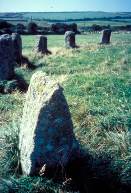
The Merry Maidens (Stone Circle at Lamorna)

The trip to Lamorna also included a visit to the Merry Maidens, a 4000-year-old stone circle, said to be young girls turned to stone because they were caught dancing on Sunday. In three adjacent fields, single standing stones are supposed to be the pipers who led them astray. South Cornwall has numerous Stone Age sites including other stone circles, as well as many burial chambers, holed stones, and quoits, or table stones.


A Cornish Mile
An overview of Cornwall’s long history can be seen at the beautiful Penlee House Museum in Penzance. There I read about a gentleman who visited Cornwall in 1602 and noted that it seemed as if “Cornish miles are much longer than those about London.” (They may have been, since distances had not yet been standardized.) I wondered if he had done a walking trip! There were a few times during our trip that I felt the distances seemed longer than those indicated on our maps, but perhaps that was because I stopped so often to admire the view. Every turn revealed a new perspective--a distant lighthouse, a natural stone archway, a hovering kestrel, or perhaps an abandoned flower field from the days when Cornwall provided London markets with early spring blooms. In our six days in Cornwall we saw a lot, but we still have a long list of things to do on another trip. Perhaps, next time we’ll head south as the Town Crier suggested.


Practical Considerations
(Although I walked the Cornwall Coast Path more than ten years ago, it is much the same today.  The following information is current.)
Getting there: There are several trains a day from Paddington Station in London to Penzance; from Heathrow, take a bus to Reading and catch the train from there. Train information in London is at 0345 484950. If you drive, take the A30 all the way from London to Penzance. Penzance is 280 miles southwest of London.
Getting around: Buses run frequently between most towns although less often on weekends. Taxis are also available.
Where to stay: Guides to bed and breakfasts in Britain are available from most large bookstores in the U.S. and from the AAA. Tourist Information Centers (TIC), located in most larger towns, can help you arrange accommodation. The TIC phone in Penzance is at 01736 362 207. In summer and holiday periods reservations are a must.
Hiking the Coast Path: I bought maps and guidebooks in London at a store called Stanfords at 12-14 Longacre Street WC2, but you can also find what you need at bookshops or outdoor suppliers in the larger towns of Cornwall. The South West Coast Path Association publishes a guidebook, see website below. (Some portions of the Coast Path are owned by the National Trust.) For short walks you can usually get maps and directions at your hotel or local TIC.

For a MAP and information on the SOUTH WEST COAST PATH go to http://www.southwestcoastpath.com/