Monday, September 25, 2017

ANGEL ISLAND IN SAN FRANCISCO BAY: a Trip Through Time

View of Golden Gate Bridge from Camp Reynolds on Angel Island, San Francisco Bay
Several weeks ago, I went with my husband and granddaughter to Angel Island in San Francisco Bay, taking the ferry from Tiburon for the short ride to Ayala Cove.
Ferry to Angel Island--about a mile from Tiburon and three miles from San Francisco.
Angel Island, a California State Park, is a great place for hiking and watching wildlife and a chance to explore and learn about the island’s unique role in California history.
Angel Island. At 1.2 square miles Angel Island is the largest island in San Francisco Bay.
After leaving the boat, our first stop was the Visitor Center, where several rooms of displays gave an overview of the many facets of the island. 
Historic plaque near the picnic area and visitor center at Ayala Cove. Headquarters of the park are also housed in the old U.S. Public Health Service Building.
For thousands of years Native American Miwok Indians from the mainland visited the island, hunting, fishing, and gathering acorns and other wild plants. Today, native wildlife includes birds, squirrels, deer and a species of mole unique to the island.
A young mule deer stopped by, seemingly unafraid, as we ate our picnic lunch.
The first European to land on the island was Spanish explorer Juan Manuel de Ayala, who moored his ship in the small cove on the north side of the island in the fall of 1775.  Following the tradition of naming discoveries after the closest feast day, he named it Angel Island in honor of the Feast of the Angels, celebrated on October 2nd.
From 1910 to 1940 hundreds of thousands of immigrants, mostly from China, were processed at the Angel Island Immigration Station.  We did not have time on this trip to go to the Immigration Station but plan to do so on another visit. 
Angel Island has had many uses over the years. Among other things it has been a cattle ranch, military base, immigration station, and quarantine station.
The rocky platform at Point Knox where the lighthouse once stood. Only the fog bell remains. In 1960 a new, more modern lighthouse and fog station was opened at Point Blunt on Angel Island and the Point Knox lighthouse and fog station was closed and removed.
The first lighthouse on Angel Island was a fog station, built in 1886 at Point Knox, a rocky outcropping on the southwest corner of the island. A light was added in 1900. One of the keepers was Juliet Fish Nichols whose heroics after the 1906 earthquake I wrote about in an earlier post on this blog.  On foggy days and nights, her job was to set the fog bell machine in motion. The 3000 pound bronze bell at Point Knox was operated by a Gamewell Fog Bell Striker machine, in which a heavy weight suspended below the mechanism powered a mallet that struck the bell.  Once the mechanism was wound, it ran for several hours.  Gamewell mechanisms were used widely at lighthouses along the coasts of the United States for many years, but were known to be temperamental.  Juliet Fish Nichols reported in her log at least eight failures of the Point Knox bell machine.  Eventually, (after the 1930's) the fog bell at Point Knox was replaced by a much more reliable compressed air siren.
Fresnel lens on display at the Visitor Center; a photo of the Point Knox Lighthouse is behind it.
The light at Point Knox was a type known as a Fresnel lens.  The glass rings of a Fresnel lens are prisms that concentrate light from inside the lens (originally provided by an oil or kerosene lamp, later by an electric bulb) making the light visible for 20 miles or more.  The lenses came in various sizes. The light at Point Knox was a 5th order red lens, one of the smaller Fresnel lenses, but sufficient for distances in San Francisco Bay.
The barracks of Camp Reynolds, the West Garrison of Fort McDowell
The remains of Fort McDowell, both the earlier West Garrison (Fort Reynolds) and the larger East Garrison are found on the island. Thousands of soldiers left from Angel Island during World War I and II. After World War II, the military bases were closed. A Nike missile site was installed on top of the island; after it was removed in 1962, the U.S. government gave Angel Island to the state of California. It is now Angel Island State Park, a fascinating place to spend the day and to relive a bit of California history.

Facilities on Angel Island include a cafe, tram tours, and Segway and kayak rentals. For more information about Angel Island and links to ferry schedules, click HERE.
For more about the history of the island and activities, go to the Angel Island Conservancy site.

For more about Juliet Nichols, her log, Angel Island, the Point Knox Lighthouse, 1906 San Francisco earthquake, and more go to https://carolinearnoldart.blogspot.com/p/extra-material-for-keeper-of-light.html .

Monday, September 18, 2017

YOSEMITE VALLEY JUNE: Water, Water Everywhere

Yosemite National Park, Path to Bridal Veil Falls
Yosemite National Park, the most visited national park in the nation, never fails to impress and, even when filled with visitors, one feels immersed in nature. As the naturalist John Muir said, “It is by far the grandest of all the special temples of Nature I was ever permitted to enter.”
Sheer rock walls are part of Yosemite's grandeur
Last June, Art and I spent several days in Yosemite with our extended family, staying at a rented house in The Redwoods at Wawona, near the south entrance of the park. One morning we got up early for the 45 minute drive over the winding road through the park (Highway 41) to Yosemite Valley, arriving there just as the sun was coming up over the peaks to the east. The air was still cool and parking areas had plenty of space. Melting snow from the previous winter’s record snowfall had filled the rivers and lakes to overflowing and the waterfalls thundered down the rock walls of the valley.
The overflowing Merced River had temporarily submerged the trees along its banks
In fact, there was so much water that some of the paths that normally cross the valley had become submerged in the middle. A few hardy tourists waded across. We opted for the boardwalk.
Walkway across a grassy marsh
We then returned to our car and followed the one-way road up the valley, stopping several times at viewpoints to take pictures and enjoy the view before parking at Half Dome Village. From there, we walked along the path through the campground to the trailhead for Mirror Lake. The 1.2 mile path, which follows Tenaya Creek, is mostly shaded and, except for a few places, mostly level. Water rushed by, tumbling over rocks where the creek narrowed.
Tenaya Creek
The reward is at the end, where the view opens up as the creek expands to a shallow lake, reflecting the surrounding view on its completely still glassy surface.
Mirror Lake
After a picnic lunch, we headed back to Wawona, stopping for a last view of the valley before going through the tunnel, where we stopped to take our final photos. Art and I were in Yosemite celebrating our 50th wedding anniversary. We couldn't have chosen a better place.
Tunnel View of Yosemite Valley with Half Dome in the distance
Final Note:  Since our visit in June, terrible wildfires have raged in and around Yosemite, filling the valleys with smoke and burning dangerously close to giant sequoia groves and to the houses and hotel in Wawona. For the latest news on the fires and other updates, click HERE.

Monday, September 11, 2017

SANTA CRUZ, California: A Walk Along the Cliff

View from the cliff, Santa Cruz, California
Two weeks ago I drove from Oakland to Santa Cruz, on the California coast, for lunch and a visit with a friend who had recently moved there. It was a beautiful day–clear skies and a warm breeze off the ocean. We enjoyed a casual and delicious lunch at Kelly’s, a combination bakery and cafĂ© on Swift Street, eating outdoors under umbrellas. Then, to work off our calories, we took a walk on the path that follows the cliff top at the University of Santa Cruz Marine Science campus.
The level dirt path, open to the public, goes around the edge of the campus and through the open areas around the various buildings.
Wooden benches are conveniently positioned along the way where one can rest and enjoy the view. Each bench bears a memorial plaque honoring the person it is named after and with a short message.
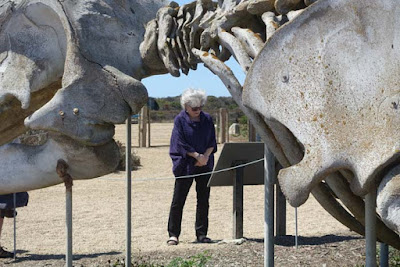
As the path turns inland toward the classroom buildings, the skeleton of a grey whale is mounted at the corner, with a sign describing the migrating and feeding habits of these huge cetaceans that pass by each winter on their way to and from their breeding grounds in Baja California and back to their summer home in Alaska. I'm told that in the winter you can see the whales in the ocean as you walk along the path. 
It is only when one stands next to the giant bones that the extreme size of these mammals is appreciated.
As we walked along the path gulls swooped overhead and platoons of pelicans sped by, searching for fish in the water below. To the south we could see people playing in the water at Natural Bridges State Park. The tide was going out, leaving small pools in the rock shelf, filled with anemones and other sea life. 
After our walk it was time for the two hour drive back to Oakland. We had certainly enjoyed a full and refreshing day.
As Henry David Thoreau once wrote:
We can never have enough of nature. We must be refreshed
by the sight of inexhaustible vigor, vast and titanic features,
the sea-coast with its wrecks, the wilderness with its living
and its decaying trees, the thunder-cloud, and the rain.


Note: We did not have time to visit  the Seymour Marine Center located on the large campus. It features a fascinating aquarium, shark pool, and touch pool filled with starfish, sea urchins, hermit crabs, and sea anemones. The Exhibit Hall educates visitors about oceanic research as well as topics such as elephant seal behavior and the sea otters' ecosystem.
We’ll have to put the Marine Center on our list of things to do the next time we go to Santa Cruz. 

Monday, September 4, 2017

GLACIER NATIONAL PARK: A bad day at Logan Pass (not really) Guest post by Caroline Hatton


Mountain goat (Oreamnos americanus), Glacier National Park

My friend and fellow children's book author Caroline Hatton and her husband visited Glacier National Park in Montana in August 2017, where, despite less than optimal viewing conditions, they saw lots of wildlife. She took the photos in this post. Caroline's latest book, C'est pas marrant  is in her native French, for ages 8 and up. It's about humorous sibling antics in Paris. Here's her report of her trip to Glacier NP.

It was supposed to be a vacation, a break from L.A. smog and traffic. Not!

As we arrived at Glacier National Park, evening winds stretched a thick blanket of wildfire smoke over the Rocky Mountains,* the brownish haze blurring the ridges visible from our cabin at Rising Sun. The next morning, a Sunday, the cold air smelled smoky and the closest peak had a faint, sickly purplish tinge. The mountainscapes looked jaundiced and washed out like watercolors by an art class drop-out.To reduce pollution and enjoy sightseeing without concern about driving and parking, we left our rental car at the St Mary Visitor Center, at the eastern end of the famous Going-to-the-Sun Road, and rode the park's free shuttle to Logan Pass. A long line of cars and assorted buses approached the pass and the trail up to Hidden Lake looked like an ant hill crawling with tourists. 
Columbian ground squirrel (Urocitellus columbianus)
Before hiking to the Hidden Lake Overlook, we squeezed onto a crowded bench for a bite of lunch. I was elbowed by what turned out to be a rude, unshaved, local resident (a Columbian ground squirrel), who proceeded to stare at me and inspect my day pack without permission.
I thumped my boot but he didn't even blink. To keep him from chewing a hole in my pack, I had to yank it away. He had targeted the corner, inside which were Planters Dry Roasted Peanuts, an unexpected sign of good taste in an otherwise uncivilized individual.
Hoary marmot (Marmota caligata), total length 2 feet ~ 60 cm or more

Having lost our appetite, we headed up the trail, onto the board walk, careful not to step on visitors crouched to hold iPhones closer to masses of pink, purple, yellow, and white wildflowers; loose toddlers; and unwashed, out of control residents (hoary marmots)**--who ate the flowers!
Seriously: not reckless, but cautious trio of bighorn sheep (Ovis canadensis)
Farther uphill, a reckless trio (three bighorn sheep) raced across the trail with no warning, between oncoming groups of hikers. It looked like a collision begging to happen. In L.A., they'd put up some kind of sign, such as those that say, "CAUTION: truck crossing!"
Slow traffic: mountain goat
Also in L.A., they have freeway signs that say, "Slower traffic: keep right."

Oh well. At least we got our money's worth, because obviously, we weren't in L.A.!

We did not hike from the Hidden Lake Overlook down to Hidden Lake because climbing back up would have required deep breathing, which didn’t seem like a good idea in the smoky air. Vistas remained hazy every one of the eight days we spent between Glacier National Park and the adjacent Waterton Lakes National Park in Alberta, Canada, but we were lucky to see one black bear, two moose, four grizzlies, a dozen deer, lots of squirrels and chipmunks, and many, many more bighorn sheep in several different locations.
All the shuttle drivers we encountered during our visit were highly professional, helpful, and friendly. They said that the park was usually much more crowded on weekends days than week days. At each stop, they radioed to the dispatcher the number of people waiting for rides in each direction, if any, for faster service. 

We’d love to go back to Glacier National Park in other seasons!

Update as of September 1, 2017:
Since we came home from Glacier, they closed the lodge at Lake McDonald one month early due to concern for the health of the staff, who had been exposed daily to smoke from the nearby Sprague Fire. All trails around and from Lake McDonald had been closed since the fire. Then that fire grew a little larger. Now it has destroyed the historic Sperry Chalet, located in the back country about seven miles from Lake McDonald. What a sad day for the park and all who have enjoyed staying at the Chalet through the years.
Hungry marmot
Footnotes
* Ten days before our arrival, a thunderstorm had generated some 150 lightning strikes, some of which started three wildfires in the park, including near the western end of the Going-to-the-Sun Road. More wildfires had already been burning or started burning afterwards outside of the western boundary of the park.
Fire is a natural process that improves habitat for many wildlife species and maintains certain forest types. In Glacier National Park, fires burn every year. Unless they threaten structures, fires are allowed to run their natural course as an integral part of managing ecosystems. Wildfires that start in summer may burn until snow falls.

** Implying that any marmot was on the trail, let alone that it almost got stepped on, is a grumpy exaggeration. The closest marmot was on the grass next to the boardwalk.

For more info:

For students to learn more about wildfires: Fire-in-Depth by the U.S. National Park Service https://www.nps.gov/fire/wildland-fire/learning-center/fire-in-depth/wildfire-causes.cfm

GLACIER NATIONAL PARK: Hike to Hidden Lake by Tom Scheaffer

GLACIER NATIONAL PARK, Montana: A Place to Renew Your Spirit by Caroline Arnold
https://theintrepidtourist.blogspot.com/2012/10/glacier-national-park-montana-place-to.html