Monday, July 26, 2021

THE LIBERTY BELL, BEN FRANKLIN, and More: Philadelphia, Pennsylvania

52 Places to Go: Week 30

The Liberty Bell, cast in 1753 by John Pass and John Stow for the Pennsylvania State House
The Liberty Bell, with its famous crack, has long been a symbol of the American Revolution. But contrary to popular belief, there is no evidence that the Liberty Bell rang on July 4, 1776, to proclaim independence. However, it did ring on many other occasions and was used to summon members of the Pennsylvania Assembly and to announce noteworthy events. It last rang in 1846 to celebrate the birthday of George Washington.
Independence Hall
In June 2014 Art and I spent the weekend in Philadelphia at a family celebration and had the opportunity to visit the Liberty Bell and other sites around Independence Mall. The wealth of historic sites reminded me how central Philadelphia was to the early history of the United States. A map inside the Liberty Bell Center shows dozens of important sites–Independence Hall, the Benjamin Franklin Museum, Betsy Ross’ House, Christ Church and the Christ Church Burial Ground, Mikvah Israel Congregation (the oldest continuous synagogue in the United States), the Franklin Mint, the new National Constitution Center, to name a few.  We visited the historic area on a Sunday morning, which had the advantage of being cooler and less crowded.
Part of historic Philadelphia
My last visit to Philadelphia was fifteen years ago and I remember going inside Independence Hall and seeing where the Continental Congress first met.  Now, in order to go inside, one has to get a ticket (which is free) and stand in line for a tour (which we didn’t do because of our limited time, although we did walk through the grounds.) On my last visit, the Liberty Bell was housed in a small building by itself.  Now it is part of a large visitor center filled with exhibits about the bell and the concept of freedom, focusing on the fight to end slavery and for equal rights for all citizens of the United States.


Exhibits in the Liberty Bell visitor center about the Pennsylvania Abolition Society.=
If you go to Philadelphia, it’s hard to avoid Benjamin Franklin. You can see where he lived, where he worked, and where he is buried.  His name is everywhere from the Franklin Mint to Franklin Court behind the Ben Franklin Museum.  Even the chairs in the lobby at the Westin Hotel where we stayed were decorated with his image.
Coins for good luck are strewn across Benjamin Franklin's Grave
Born in 1706 in Boston, Benjamin Franklin moved to Philadelphia as a young man, where he lived until is death in 1790 at the age of 84. Among his many accomplishments are that he founded the Philadelphia Library, invented the Franklin stove, was the first to utilize electricity, was the postmaster of Philadelphia, and a delegate to the Continental Congress. At his grave site in the Christ Church Cemetery there are two plaques.  One lists important dates in his long life.  The other has three quotes about him.  My favorite is by French writer Anne-Robert-Jacques Turgot who wrote: “He tore from the skies the lightning and from tyrants the scepter.” (1779)

This trip made me realize that I need to go back to Philadelphia when I have more time so I can do justice to all the fascinating history in the city.  
Plaque at Christ Church Cemetery with famous quotes about Benjamin Franklin

This article was first published 7/7/14

All text and photographs copyright Caroline Arnold.

Monday, July 19, 2021

ROSIE THE RIVETER/ WWII HOME FRONT Park and Visitor Center, Richmond, CA

52 Places to Go:  Week 29

Rosie the Riveter/WW II Home Front National Historical Park Visitor Center, Richmond, CA
During World War II, shipyards, factories, military bases, and businesses of all kinds around San Francisco Bay hummed with activity. At the Rosie the Riveter/WW II Home Front National Historical Park in San Francisco’s East Bay one can explore how American civilians, especially women, lived, worked and contributed to the war effort at home.
"I specifically didn't do anything...great, but I participated in something that was great."
I visited the museum with my family in 2018 when they were visiting us in Oakland for the holidays. I had passed the sign for the turnoff to the park many times before as I sped on the 580 Freeway from Oakland to the Richmond/San Rafael Bridge on my way to Marin County. This time we took the exit. The park is at the edge of the Bay, looking onto a distant view of Angel Island and the city of San Francisco.
The Visitor Center is in the restored Ford Building, an assembly plant for jeeps and other military vehicles during the war--the largest assembly plant on the West Coast. Now, as a museum, it is filled with exhibits about the history of Richmond's wartime industries and workers.
As we walked through the museum, it felt like a trip back in time. Life-size dioramas dramatize daily life for the thousands of workers who worked at various wartime industries, many living in crowded rooms due to the housing shortage.
Many workers were women, who took over jobs previously done by men. These were the “Rosie the Riveters.”

Who Was Rosie?
Even during World War II, the term “Rosie the Riveter” served as shorthand for the women workers flooding the industrial workplace. The first Rosie popped up in a popular tune released in early 1943. As the song put it, “She’s a part of the assembly line. / she’s making history, ‘ Working for victory, / Rosie the Riveter.”
Artist Norman Rockwell was undoubtedly aware of the song when he painted the May 29, 1943, cover of the Saturday Evening Post. His subject is a young riveter on break, with her lunchbox clearly marked “Rosie.” The one-two punch of the song and magazine cover made Rosie a lasting icon.


Child day care centers, funded by the government, solved the problem of the “eight-hour orphans”-- the children of working mothers. At home, people were encouraged to plant “Victory Gardens” as a way of contributing to the war effort by growing their own food.
Displays also told the darker stories of Japanese families forced to leave their homes to go to internment camps.
View of Angel Island and San Francisco from the front of the museum.

We watched a short film and listened to a talk by a very knowledgeable docent. We didn’t have time to fully appreciate all of the exhibits. We'll have to go back another day. As we returned to our car in the parking lot we passed the Rosie the Riveter monument in the center of the large park. The park is a popular spot for bikers and walkers. Next time we visit, we’ll allow more time to enjoy the fresh air and spectacular view across the bay.

This article was first published 10/8/18.

All text and photographs copyright Caroline Arnold.


Monday, July 12, 2021

THE LITTLE WHITE HOUSE: Roosevelt’s Retreat in Warm Springs, GA

52 Places to Go: Week 28

Franklin D. Roosevelt's "Little White House," Warm Springs, GA
Franklin D. Roosevelt first came to Warm Springs Georgia in 1924 in hopes that the warm waters of the natural springs there would help him recover from polio. Over the next twenty one years he came there many times, staying in the small white cottage he built on land he purchased nearby, which, during the years he was President (1932-1945) became known as the “Little White House.” It was there that he died on April 12, 1945, when he suffered a massive heart attack while sitting for a portrait by painter Elizabeth A. Shoumatoff.
Elizabeth A. Shoumatoff's unfinished portrait is on exhibit in the visitor center
Today Roosevelt’s house and a museum with mementos of his life in Warm Springs are open to the public. It is operated by the Georgia State Parks as a State Historic Site. The treatment pools where he swam can also be seen, along with exhibits about the kinds of therapy that was offered to victims of polio like Roosevelt.
Bullock House Restaurant
I visited Warm Springs when Art and I were in Georgia visiting relatives near Atlanta in May 2018. We took a day trip, arriving in time for lunch at Bullock House Restaurant on the town’s historic main street, choosing from a buffet of classic Southern foods including catfish, hush puppies, collard greens, fried chicken.
FDR was an avid stamp collector
After lunch our first stop was the Little White House Visitor Center, where we purchased our tickets and watched a short film before touring the museum. The museum is filled with items from Roosevelt’s personal life such as the 1938 Ford Convertible with hand controls, his stamp collection, his cane collection, and a 1930s kitchen with his “Fireside Chats” playing on the radio.
In a speech given January 6, 1941 Roosevelt insisted that people in all nations of the world shared Americans' entitlement to four freedoms: the freedom of speech and expression, the freedom to worship God in his own way, freedom from want and freedom from fear.
On one wall is a display of the Four Freedoms posters made from paintings by Norman Rockwell. They were used to promote the selling of war bonds during World War II. On another wall is a series of displays honoring Franklin’s wife Eleanor.
Eleanor Roosevelt
From the Visitor Center we went outside for the short walk to Roosevelt’s house, stopping at the guest house and servant’s quarters. Inside Roosevelt’s cottage, a very knowledgeable park ranger answered questions and helped us imagine what it was like when Roosevelt lived there.
Wheelchair fashioned by mounting a kitchen chair on wheels
The rooms inside the cottage are small and cozy and largely unchanged since Roosevelt’s time. A special wheelchair, small enough to fit through the narrow doorways sits in the corner; next to it is a statue of Fala, Roosevelt’s faithful dog.
Photographs of FDR at the Warm Springs Pools
A mile from the museum are the pools where Roosevelt went for therapy. No longer used, they have been drained but photos from the past show them full of people.  A small museum at the pools tell about the springs and the town’s history, including Roosevelt’s founding of the adjacent Roosevelt Warm Springs Institute.
The pools once used by FDR were replaced by an indoor pool closer to the treatment center.
A visit to Warm Springs is a trip back in time. It is one thing to read about FDR in the history books. It is another to walk in his footsteps. As the cover of the park brochure proclaims, a visit to Roosevelt’s Little White House is to experience the inspirational retreat of a man who changed America.
The Little White House is located 70 miles south of Atlanta, Georgia. For more information go to www.GeorgiaStateParks.org .

This article was first published on 7/16/18.

All text and photographs copyright Caroline Arnold.

Monday, July 5, 2021

BATTLE OF GETTYSBURG: Reliving History at Gettysburg, Pennsylvania

52 Places to Go: Week 27

Reliving History
The hot July sun beat down on the sloping field in southern Pennsylvania, just as it had on July 1-3, 1863 when the Battle of Gettysburg was fought in this quiet farm community just north of the Mason-Dixon line. I wished we had brought parasols like those I saw carried by the hoop-skirted ladies hovering at the edge of the crowd. Directly in front of us, on the stubble of cut hay, we watched gray uniformed Union soldiers loading their cannons. On the other side, beyond a stone wall, Confederate soldiers, armed with their own cannons and muskets, lined up their ammunition while drummer boys and flag bearers got ready to lead the charge. The regiment doctor, his white apron already stained, prepared to treat the wounded.

History was repeating itself--or so it seemed. This time, however, the soldiers and ladies dressed in 1860's attire were actors playing parts. Observers sat safely on bleachers or stood along the sidelines while the action was narrated over a loudspeaker. (The announcer also filled us in on background information--a benefit for people like me who were a bit rusty on Civil War history.)

KA-BOOM! The first cannon volley thundered across the field and smoke billowed skyward. Soldiers marched forward and fell in battle. KA-BOOM! KA-BOOM! KA-BOOM! For nearly an hour the cannons boomed and muskets fired with deafening realism. When the attack was over “victims” jumped up unharmed and the soldiers, sweltering in their authentic woolen uniforms, guzzled Gatorade.

Pickett's Charge
We were outside the small town of Gettysburg, Pennsylvania, at the reenactment of Pickett’s Charge, an authentic recreation of this pivotal Civil War battle presented by Gettysburg Living History Inc., one of several living history companies that stage Civil War events in Gettysburg. Every year during the 4th of July weekend thousands of Civil War reenactors from all over the United States congregate in Gettysburg to recreate events ranging from battles and drill competitions to medical demonstrations and fife and drum concerts. They also put on fashion shows, art exhibits, impersonations, and talks. Some events are free while others require tickets.

For my family, watching and talking with the reenactors was an ideal opportunity to visualize history as it happened. Dressed in authentic clothing and living in a tent encampment for the long weekend, the reenactors at Herr’s Ridge lived and breathed the history of the Civil War era. Although there are excellent exhibits at the National Park Visitor Center and other museums in town nothing makes history more real than meeting people who have incorporated it into their lives.

What the Women Wore
When the battle was over the announcer invited us to walk on the battlefield and through the encampment. While the men in our group examined weapons and cannonballs, my daughter and I were much more interested in talking with the women. Many wore elaborate costumes, varying from hoop skirts and sheer dimity summer dresses to more practical shirtwaists and sunbonnets. We learned that women reenactors had to carefully research their costumes to make sure that each part was consistent both with the time period and their character’s age and social class. Snoods, or hairnets, for instance, were only worn by young women during that period and were a kind of fashion fad.

We chatted with two women whose husbands had been on the battlefield. Both said they had been drawn into reenacting by their husbands’ military interest but once “bitten by the bug” it was hard to resist becoming an enthusiastic participant. Weekends such as this one were family events and included children who were also dressed in period clothing.

When we asked about the authenticity of women and children at this event we got a short history lesson on women’s participation in the Civil War. While most women stayed at home during the Civil War, maintaining the family farm or business while their husbands were fighting, many wives followed the camps, especially if their own homes had been destroyed by the war and they had no relatives to take them in. In a few cases, women disguised themselves as men, and fought as soldiers. If they were discovered, they were evicted from camp and lucky not to be shot for treason.

Sutlers and Vendors
At the Herr’s Ridge battlefield we also visited the area designated for sutlers and vendors. A “sutler,” I learned, is a person who follows an army for the purpose of selling the troops provisions, liquor, etc. The tented sutler and vendor booths contained everything from modern day food and drink to genuine and authentic reproduction Civil War uniforms and weapons. Reenactors are expected to be completely accurate down the stitching on the uniforms.

Vendors also sold women and children’s clothing, household goods and toys of the period. In a booth that specialized in jewelry I learned another new word, “chatelaine,” an ornamental clasp that the mistress of a house wore at her waist and which had hooks for attaching keys to the pantry, a watch, and perhaps a small purse. The chatelaine we examined was of chased silver and clearly meant as a status symbol as well as a practical item.

Steeping Yourself in History

If you want to thoroughly steep yourself in the Civil War era you can stay in the recently renovated historic Gettysburg Hotel and eat at the Dobbin House Tavern. Other area attractions include the National Park Service Visitor Center and Cyclorama on Taneytown Road, tours of Dwight Eisenhower’s farm (tickets and shuttle from the Visitor Center), and the national cemetery across from the Visitor Center.
If you like your history dramatized, you should plan your trip to Gettysburg so that it includes a summer weekend. Reenactments of various kinds of Civil War events occur on almost every weekend between May and October. Another way to put drama into your trip is to tour the battlefields by trolley. The tour guide plays the part of several Civil War characters. (We chose instead to buy the Auto Tape Tour at the National Civil War Wax Museum, 297 Steinwehr Avenue, for a self tour so that we could visit at our own pace.)

Getting there: Fly to Harrisburg, Pennsylvania and then go by car to Gettysburg. (South on 15 from Harrisburg, exiting on US 30 to Gettysburg. A scenic 39 mile drive.)
Current Gettysburg information: Gettysburg go to http://www.gettysburgaddress.com. Click on reenactments for current information.

This article was first posted 4/13/11.  The trip occurred in July 1997. For a few more pictures from the trip click HERE. You can find information about current reenactments at Gettysburg by searching the web.

All text and photographs copyright Caroline Arnold.

Monday, June 28, 2021

WEEKEND ESCAPE at INVERNESS and POINT REYES NATIONAL SEASHORE, CA, Guest Post by Matt Arnold

 52 Places to Go: Week 26

Point Reyes National Seashore, California

In June 2018, taking advantage of their daughter being away at camp, my son Matt and his wife Kate escaped their busy life in Oakland, CA, for a short road trip to explore Inverness and the area around Point Reyes.  Here is Matt's report along with his excellent photos.

 
Surprisingly close to the Bay Area, you feel a world away in the coastal town of Inverness, entering a part of California that seems from another era. Just the drive to the coast is worth the trip. After leaving the East Bay, we utilized the Nicasio Valley Road route.  Other scenic options include taking Sir Francis Drake Blvd through San Rafael or going through Mill Valley and Stinson beach via Highway 1.

Once leaving the outskirts of San Rafael and turning off of the 101, you are immediately thrown into a series of alternating quintessential California landscapes--from rolling golden hills dotted with Oak trees, to windy roads dodging giant Redwoods, to coastal bluffs filled with scrub brush, to pastoral grazing lands for cattle. The long and windy road feels less long, surrounded by such serenity. 
Looking East across Tomales Bay from "downtown" Inverness
We stayed, via Air B & B, at a small studio in the heart of Inverness, one block from Tomales Bay and Chicken Ranch Beach, looking eastward across Tomales Bay.
The topography of the area is defined by the San Andreas fault, and the collision of the Pacific and North American tectonic plates that slice their way through the Pacific edge of California. The fault line runs from Bolinas and Stinson beach to the south, following Highway 1 and then diving back into the water, forming the large and narrow Tomales Bay (think Baja California but upside down.)
Forster's Terns at Abbott's Lagoon
To the west of this fault line is Point Reyes National Seashore. Here, there is a vast collection of trails leading across the ridge with pine and oak forests, down to wild bluffs, abandoned beaches, rugged coastline, and a series of tranquil lagoons and marshland, with extensive tidal flats. There is a series of roads that lead to several of these locations, though trail heads will take you quite quickly away from the busier outlooks.
Looking across Tomales Bay from Tomales Bay State Park
The towns of Inverness and nearby Point Reyes Station, personify what would best be termed the West Marin (County) aesthetic. There is a touch of what might be blamed on the hippie roots of the area, and words like free, organic, artistic--attached to the lansdcape--all seeming appropriate. On a gastronomic level, this area is the intersection of the foodie culture that originated in the Bay Area, (fresh/locally sourced/organic) and the bucolic Old Califronia (where this produce is actually grown). Many brands, which are familiar to Bay area foodies (Marin Sun Farms, Cowgirl Creamery, Nicasio Valley Cheese, Strauss Creamery, Tomales Bay Oysters, etc.) are all located in the surrounding pasture lands/tidal zones, with several outlets in Point Reyes Station to sample their wares. In addition, the restaurants all serve top notch foodie fare, with oysters on the half shell at even the smallest sandwich shops. It is really hard to eat a meal here that isn't absolutely delicious.
There are still a few working farms on the land, and cows grazing, harking back to a true California of old.
The town of Inverness sits right at the edge of the more wild Point Reyes National Seashore, and after you round the bend on Sir Francis Drake Blvd and leave town, you really feel like you are leaving much of civilization behind. The scenery can be breathtaking. Most of the land is wild, with amazing vistas stretching from the hills down to the tidal flats or cliffs on the coast.
Tidal flats photographed in black and white at Drake's Estuary
On our particular trip, after a good night's sleep Friday, we woke early on Saturday morning and set out to explore (via our ritual exercise) the trail system in Point Reyes. We picked up coffee and breakfast at the IP Market (short for Inverness Park), which offers an excellent deli/cafe bar in addition to normal market supplies. Lots of fresh baked goods, and options for sandwiches (later I had their amazing Tri-Tip sandwich). We went to Bear Valley trailhead where Kate took off on her Saturday run, with the trail gently climbing and then descending to the coast, where several trail options will get you to the beach. Here you can get to waterfalls that flow directly into the Pacific (I think called Tidal Falls). 
Several trails in Point Reyes allow bike riding.
While Kate ran, I took off on a bike ride. The trail riding is a little more limited, and many of the trails only allow bikes on certain portions (only half of the Bear Creek trail is open.) After consulting a map I tried to string a few of the trails together, needing to use a few park roads to skip between trails, but ended up with a very satisfying ride, with the trails almost all to myself for several hours.
After our respective exercise regimens were checked off the to-do list on some pretty cool trails, we headed back to our studio. Sandwiches were picked up at the IP market and we were able to enjoy these at Chicken Ranch Beach (did I mention the Tri Tip?) 
Even in mid-June there were still plenty of wildflowers in bloom.
After lunch, another trip into Point Reyes Seashore to explore more hiking trails took me to a short trail to Abbott's lagoon.This was recommended by our AirB & B host and it did not disappoint.
Wildflowers were in bloom on the trail down to the lagoon plus an impressive collection of birds; others on the trail had just seen river otters in the lagoon (though I missed out.)
Sand dunes await at the mouth of  Abbott's lagoon, which then stretch onto the actual coastline and Point Reyes Beach.
This is a great trail to see seabirds that dot the shores around the lagoon. Once at the actual ocean front, one could potentially walk up and down the sandy beach for miles.
Dinner that night was in Inverness at the Salt Water Oyster depot. Despite being at the edge of civilization, the food was excellent. We enjoyed the local oysters, as well as scallops, and clams (linguini) and shrimp (cassoulet). When in Rome...
Sunday morning arrived sooner than we would have wished, and after cleaning up and checking out, we had one last dive into the National Seashore trail system, this time at the Estero trail head to a system of trails (most of them bike-able) surrounding Drake's Estero. This offered more views of the tidal estuary along mostly brush covered coastline.
On the Estero trail we caught several white tail deer and their fawns as it was "fawn season".
Despite the decent weekend weather, and relative proximity to San Francisco, being in the park never felt crowded. Though Bear Valley Visitor Center does get busy (it is the closest trail head to SF), we were there early, and almost every other trail that we explored we had mostly to ourselves. There were miles of some trails where I did not see another soul. This sense of isolation, so close to home, was wonderfully refreshing.
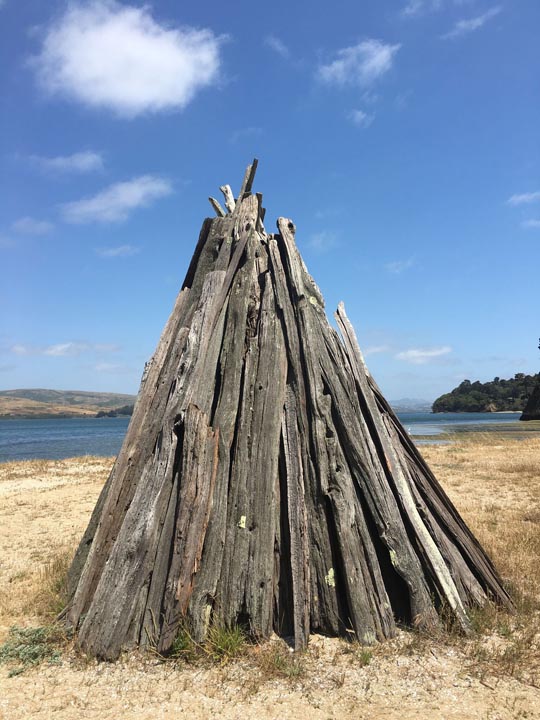
A short hike at Tomales Bay State Park to Indian Beach led to several reproductions of cone shaped Miwok bark shelters as part of a cultural exhibit.
On the way out of the National Seashore, we had one more stop on the beach, this time hitting Tomales Bay State Park, carved into the western edge of the bay, taking a short hike from Hearts Desire Beach (which was full of picnickers, kayakers, and BBQ) to Indian Beach.
An unusual thistle like plant along the trail to Abbott's Lagoon
Unfortunately our weekend was coming to an end. Reversing course on Sir Francis Drake Blvd brought us back through Point Reyes Station where we stopped for lunch. Again, we ate well, as the comfort food prepared at Side Street Kitchen was simply amazing (oysters, pork Belly BLT, pulled pork sandwich, salad). We picked up some cheese to take home across the road at Cowgirl Creamery, and returned to civilization through Nicasio Valley back to Oakland.
Lupins along Drake's estuary along the Estero trail
Despite packing a lot into the weekend, we felt refreshed and recharged for the week ahead. It felt like we barely scratched the surface of Point Reyes National Seashore and Tomales Bay, and left wanting to return for more. In particular, the Tule Elk Preserve on the northern tip, on the way to Tomales point, as well as the more famous and picturesque lighthouse at the opposite end, are on the list of things to get to on our next visit, or even camp in the park. Another trip will have to be made to actually kayak on Tomales Bay (Blue Waters Kayak) as well.
With only a small amount of traffic leaving Oakland, it took us around 1 hour, 20 minutes to get from the Bay Area to Inverness and Point Reyes.  For a map of Point Reyes click HERE. I hope you enjoy this report and are able to experience this area of California for yourself.
Abandoned fishing boat providing the classic Inverness snapshot


This article was first published July 2, 2018.

All text and photos copyright Caroline Arnold.

Monday, June 21, 2021

SUNDIAL BRIDGE, Architectural Wonder in Redding, California

 52 Places to Go: Week 25

Sundial Bridge, Redding, CA. The pylon is so tall (217 feet) I had to tip my camera sideways to get it all in.
In the spring of 2014, I was in Red Bluff, California, doing presentations to students in the historic renovated State Theater. At the north end of the San Joaquin Valley, Red Bluff is about 100 miles from Sacramento along Route 99.  From the main street of this charming Victorian town I could see across the Sacramento River to the snow-capped top of Mount Lassen to the west.

State Theater, Red Bluff, CA
One afternoon, after my presentations were finished, I drove 30 miles north to Redding to see the famous Sundial Bridge and take a walk along the river.  The Sundial Bridge, opened July 4, 2004, spans the Sacramento River at Turtle Bay. A suspension bridge designed by Spanish architect Santiago Calatrava, it is both beautiful and eco-friendly. The huge pylon (the sundial arm) connects to cables that support the bridge, allowing it to avoid interrupting the nearby salmon-spawning habitat since there are no supports in the water.  
The bridge walkway is made of steel, glass and granite.
The translucent glass surface lets light through to the water’s surface, both adding to the bridge's aesthetic qualities and minimizing its impact on river life. The bridge is open only to pedestrian traffic.  The view from the bridge is magnificent. Looking west toward the foothills and coastal range, I watched a fisherman trying his luck and a flock of Canada geese floating in the water.
Sacramento River, Redding, CA, view from the Sundial Bridge
I walked across the bridge from the south side of the river, ending at a large open area ringed with markers showing where the tip of the sundial’s shadow falls at the summer solstice.
At noon on the Summer Solstice, the Sundial's shadow reaches this marker.
From there I took a short walk in the Botanical Garden where a variety of spring flowers were in bloom.
Botanical Garden in the McConnell Arboretum
When I returned to the other side, I visited the Turtle Bay Museum, a small nature museum with exhibits featuring wildlife along the river.  I then walked along part of the extensive trail system that borders the river. It was a beautiful spring day and I was hoping to catch sight of the bald eagles that I was told had a nest along the river.  I didn’t spot any eagles but heard numerous smaller birds and saw plenty of ducks and geese in the water. Someday, I’d like to go back when I have more time and bicycle along this beautiful stretch of California river habitat and enjoy more of its wildlife.

For more about my visit to Red Bluff, see my May 28, 2014 post at Caroline Arnold's Art and Books.

Sacramento River Trail near the Turtle Bay Museum

This article was originally published 9/29/14.

All text and photographs copyright Caroline Arnold