Monday, May 30, 2011

Chile's Atacama Desert: Part II

(Continuation of our trip to Chile, December 2009)

Ancient Rock Art, Llamas, and Geysers
Pregnant Llama Petroglyph
The focus of our second day’s trip was an ancient petroglyph site in the foothills of the Andes. This turned out to be a private tour, as no one else from the hotel wanted to go there that day. About an hour’s drive north of San Pedro, we approached an open valley surrounding a semi-circular rock outcrop. Even from a distance I could see the outline of a llama on the first boulder. Deeply incised on the vertical surface, it was nearly life size. The surprise, as we got closer, was that there was another smaller llama drawn inside the larger one, perhaps to indicate fertility. Although it is difficult to date rock art, it is believed that some of the images are thousands of years old. Scrambling up the boulders we saw more llamas big and small, as well foxes, pumas, jaguars, snakes, flamingos, and human figures with feather headdresses. As we stood there in the shadow of these ancient images, it was easy to imagine prehistoric hunters resting here on their way to the next oasis. The extremely dry climate is ideal for preserving rock art, and in many cases the drawings appear as fresh as if they were made yesterday.

Terraced Farms and Llamas

Llama with decorative ear tassels near Machuca
For our picnic lunch we went to Rainbow Canyon, named for the unusual variety of colorful rock formations. Shade was in short supply, but we found a large rock whose shadow was just big enough to set up our table. For our final stop we drove to the remote village of Rio Grande for another example of terraced farming. The contrast between the small but lush fields at the base of the river canyon and the stark, steep walls that contained them was huge. On the way back to the highway, we spotted a group of guanacos, wild relatives of llamas and alpacas, domestic animals that are kept for their wool and meat. The following day we had a chance to see llamas with their colorful ear tassels in the tiny village of Machuca and to try barbecued llama meat. But the main event of our last day was a visit to the Tatio geysers.

The Highest Geyser Field in the World
Tatio Geysers
At 14,000 feet, the Tatio geyser field in the Andes is the highest geyser field in the world. Recently, it was declared a protected area and helpful signs in both Spanish and English are being installed. The optimal time to visit is at sunrise when the cold air condenses the rising steam into small dense clouds. Since the drive from San Pedro is about an hour and forty minutes, we met at 5:15 a.m. for our departure. Fortified with a cup of coca tea (which tastes just like any herb tea and is said to combat altitude sickness) we dozed in the van for the ride up. It was pitch dark when we left, but by the time we arrived the sun was beginning to shimmer through the mist. I was worried about being light-headed at the high elevation, but, as long as I didn’t move too fast, I found I had no trouble walking around the geyser field. We had been advised to wear warm clothes because dawn temperatures are often below freezing, so I bundled up. All around us geysers spurted, hot pools bubbled, and steam puffed dramatically out of dozens of vents. Near a spring, a pool had been excavated that mixes cold spring water with the nearly boiling geyser water to make a giant hot tub. It was filled with bathers, although we didn’t try it ourselves. Instead, our guide set up our breakfast overlooking the geysers. By the time we finished, most other people were gone, and a group of vicunas moved in to graze on the tough grasses that grow at the edge of the geyser field. Vicunas, valued for their unusually fine wool, are the delicate and extremely endangered other wild relative of the llama. We left and they had the mountains all to themselves.

Reliving History in Books
Church, Machuca
In preparation for the trip to Chile, I read two books: Ariel Dorfman's fascinating account of his personal journey to the Atacama in his book Desert Memories and Isabel Allende’s book Ines of My Soul, the dramatic retelling of Chile’s history from the point of view of the woman who accompanied the Spanish explorers as they made their way south in the mid-1500's. Much of the book details their arduous journey across the Atacama. Now, having been there, I can begin to appreciate the hardships they faced, but unlike those early explorers, we returned each day to the comfort of our very gracious hotel.

Heading South
That evening we boarded a plane for our return flight to Santiago. The combination of dramatic landscape, extreme climate, exotic wildlife, ancient history, and rich local culture had made for a unique vacation. Now we were on our way to meet family and to spend the rest of the trip immersed in contemporary Chilean life. As we neared the capitol, I looked out the window at lush green fields below, and was struck anew that I had just left the driest place on earth. Although the paper showed no rain in the immediate forecast, there was a chance that I might need the umbrella packed at the bottom of my suitcase.

Getting there: After flying from the U.S. to Santiago, the capitol of Chile, we took a local flight on Sky Airlines to Calama. Lan Chile also flies there. (Calama is 1225 kilometers from Santiago.) Our ground transportation to and around San Pedro was provided by our hotel, the Tierra Atacama, but it is possible to rent a car and drive yourself. (The main road is paved but most other roads are dirt.) Click here for a MAP of Chile. (Calama and San Pedro de Atacama are east of Antofagasta near the Bolivia border.)
Did we need to speak Spanish? Although we can get along in basic Spanish, almost everyone at the hotel spoke English. English was the international language for us and the other international tourists, many from Brazil and Europe. Except for one person, there were no other Americans at our hotel.
When did we go to Chile? Art and I made this trip to the Atacama in December 2009. We also spent time in Santiago, Rancagua, and the beach town of Iloca (later greatly damaged by the earthquake and tsunami.)

Monday, May 23, 2011

Chile: Atacama Desert, Part I

Flamingos, Oases, and Volcanoes (December 2009)

Flamingos in the Salar de Atacama
Like a bevy of pink ballerinas, the flamingos tip-toed across the salty lagoon, sweeping their wide bills through the shallow water in search of food. Then, with a burst of wide wings they launched themselves into the sky, and became silhouetted against the sunset and the towering mountains of northern Chile. We were in the Atacama desert, a land of stark beauty and surprising wildlife. With less than an inch of rainfall each year, the Atacama is the driest desert in the world. And yet, it has been home to people and wildlife for thousands of years.

At the Foot of the Andes
To get to the Atacama, we had flown north from Santiago to the mining town of Calama. As the plane descended into the airport we circled over a giant hole in the earth, the largest open pit copper mine in the world. Trucks loaded with copper ore looked like toys as they wound their way up its steep sides. At the airport we were met by Juan, our driver from the Tierra Atacama, our hotel in San Pedro de Atacama, the oasis town 75 miles away that would be our base. It was December, early summer in the southern hemisphere. Technically we were in the tropics, but the altitude, about 8,500 feet, meant that the temperatures were comfortable.

View of the volcano Licancabur from our room at the Tierra Atacama

At the hotel we were escorted through a garden of newly planted flowers and fig trees to our spacious room. We had a direct view of the volcano Licancabur, which at 19,400 feet high dominates the skyline and has been imbued with religious significance since ancient times.
Our all inclusive plan meant that everything for our stay was taken care of–meals, transportation, guides, entertainment. So, before relaxing with our pisco sours (the classic Chilean cocktail), we met with the trip planner who wanted to make sure that our three days would be filled with the activities we desired.

San Pedro and Toconao, Oases in the Desert
For day one, we chose a morning trip to the Valley of the Moon, spectacular rock formations just to the north of San Pedro.
View of the Valley of the Moon
After lunch, on bicycles provided by the hotel, we rode over the bumpy dirt road about a mile into the center of town. Fed by water flowing down from the mountains, San Pedro de Atacama has long been an agricultural center and was a stopping place for Pedro de Valdivia, one of the founders of Chile, as he made his way south from Peru in 1540. Near the main plaza there is a church and small museum containing ancient artifacts. A covered arcade nearby has souvenir stalls with blankets, pottery, jewelry, and other crafts, mostly from Peru (to the north) or Bolivia (a few miles to the east, on the back side of Licancabur.)

At 5:00 we met our guide and fellow travelers for a trip to the National Flamingo Reserve. En route we stopped at the small oasis town of Toconao where we toured terraced gardens filled with apricot, quince, fig, and other fruit trees. We also went into the historic church to see an elaborate Christmas manger scene, complete with llamas, a volcano, and tiny glass flamingos.

Flamingos and Giant Salt Flats
We then climbed back into the van and drove along a road of finely crushed salt through the sea of jagged crystals that form the giant salt flat of the Salar de Atacama, once an ancient inland sea. Before following the walkway to the lagoons, we toured the small visitor center to see exhibits of the flamingo life cycle. Three species of flamingos can be seen feeding in the lagoons, the Chilean, Andean and James flamingos. Periodically the birds launch themselves into the air, flapping their wide wings and honking like geese as they rearrange themselves for the night. As we watched the birds, the sun slowly sank in the west, turning the hills first orange, then pink, and finally the sky grew dark, revealing the unfamiliar southern constellations, sparkling in the clear, dry air. It was a spectacular end to our first day.
Sunset and Flamingos

Part II will cover our visits to ancient petroglyphs and the Tatio Geysers.

Getting there: After flying from the U.S. to Santiago, the capitol of Chile, we took a local flight on Sky Airlines to Calama. Lan Chile also flies there. (Calama is 1225 kilometers from Santiago.) Our ground transportation to and around San Pedro was provided by our hotel, the Tierra Atacama, but it is possible to rent a car and drive yourself. (The main road is paved but most other roads are dirt.) Click here for a MAP of Chile. (Calama and San Pedro de Atacama are east of Antofagasta near the Bolivia border.)
Did we need to speak Spanish? Although we can get along in basic Spanish, almost everyone at the hotel spoke English. English was the international language for us and the other international tourists, many from Brazil and Europe. Except for one person, there were no other Americans at our hotel.
When did we go to Chile? Art and I made this trip to the Atacama in December 2009. We also spent time in Santiago, Rancagua, and the beach town of Iloca (later greatly damaged by the earthquake and tsunami.)

Monday, May 16, 2011

THE AFRICA TRIP, 40th ANNIVERSARY

Caroline and Jennifer (age 18 months), Uganda, 1971

Trip of a Lifetime, East Africa, 1971
 In 1971, my husband, Art, along with four other graduate students at Rockefeller University in New York, embarked on a four month field course in animal behavior in western Uganda.  I didn’t want to miss out on a chance to go to Africa, even with a year-old baby (our daughter, Jennifer) to look after. One other student wife, Mary Sue, went along on the trip and we became traveling companions.  During the first six weeks of the course, while our husbands were working in a forest near Fort Portal, Mary Sue, Jennifer, and I traveled by ourselves to Kenya and Tanzania.  Then, for the second half of the course, which was conducted in a savannah environment in Queen Elizabeth National Park, we were able to join our husbands.

This year, 2011, marks the 40th anniversary of the Africa trip, a key life event for everyone who participated.  The following reminiscences were part of a collection of memories compiled to mark the occasion and to honor of Peter Marler, who conceived of and organized the trip.  The Africa trip experience can never be repeated.  Africa, and we, have changed greatly in the last forty years. This blog post is strictly a trip down memory lane.  I hope you will enjoy reading it.

Impact on My Life
As a wife, I was not involved with the course itself, but without it I would never have had the opportunity to go to Africa. At the time, I had not yet begun to write books for children, but my experiences seeing wildlife, meeting people who lived and worked in Africa, and just being there has been important for many of the books I’ve written since then. In a larger sense, the trip also greatly impacted my world view. Before then, I had never traveled outside the United States and had no idea what it was like to live in a third world country or in a place so rich with wildlife. From the time I was a child, I had always dreamed of travel and adventure. The trip to Africa certainly fulfilled that dream. When I do school presentations and kids ask me what was the most exciting place I’ve ever been, the answer is always the same–Africa.

My memories of the three months in Africa are vivid, reinforced by the hundreds of photos we took (some appear in my books) and by letters and diary entries. My parents eagerly awaited my weekly letters, vicariously traveling Africa with me. My father typed all the letters, making them legible, and put them into a book. I have put a few excerpts below. I used my diary mostly to record animal sightings, brief reports of the events of the day, and our dinner menus. One entry says we ate stewed waterbuck, from meat given to us by a park ranger! The diary also documents the arrival of the Marler family at QE, a greatly anticipated event.

Thank You, Peter Marler
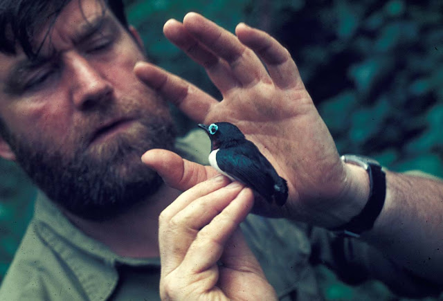
Dr. Peter Marler and Jameson's Wattle in the Kibale Forest near Fort Portal

I remember that Peter Marler had accompanied us on the trip from New York to Uganda, herding us through the airport like a troupe of wayward Cub Scouts. He had made this trip before, and I was grateful for his expertise both in the larger organization and in the details. In the Amsterdam airport, he introduced us to smoked eel sandwiches. In Kampala he took us to an Indian restaurant to try the delicious East African style samosas. He also pointed out the “bat tree” along the main road, where hundreds of fruit bats hung like small black umbrellas during the day. After helping the students set up at Kanyawara, Peter went back to New York, returning a month later with Judith and the kids. They camped out not far from us at QE and I remember being glad to have them nearby.

Only now do I realize the scope of the Field Course and how Peter’s vision for it made it happen. Now, on the fortieth anniversary of the Africa trip, I would like to thank Peter for creating the Field Course and for allowing me and Jennifer to tag along, providing us with the opportunity to have our own African experience and to share a bit of Art’s. Together with Art’s experiences during the course, and our travel together afterward in southern Uganda, this period still ranks as the most outstanding in our lives.

UPDATE July 14, 2014:  Sadly, Peter Marler passed away July 5, 2014.  Click HERE for his obituary in the Los Angeles Times.  Peter was a great friend, inspiring teacher, and intellectual giant.  He will be greatly missed.

The following entries are from my diary (in italics) and letters to my parents in California:

Queen Elizabeth National Park

The Students Camp:  Our accommodation at Queen Elizabeth (our room is the open door)

June 23, 1971
Arrived at Queen Elizabeth Park.

June 27, 1971

Mweya is an open, almost stark bluff above a large lake and channel which are filled with fish and hippos. At night the hippos come out of the water and up here to feed on the bushes, so one cannot step out of doors after dark. There are also elephants, bush pigs, and marabou storks, which wander in and out the camp area day and night. The windows of our room face the “Canteen”–the local native hotspot–and at night we hear loud music from that side, while from the other side we hear snorts of the hippos and elephants. I was under the impression that someone came in the night to empty our garbage can until I realized that the elephants and marabou storks were removing it all.

I am quickly reviving all my Girl Scout talents. We aren’t actually “camping” in that we have a room with three cots in it, but I am cooking all our food over a wood fire (which is tricky since we have a bare minimum of equipment.) The biggest problem besides obtaining food is water since it all must be boiled. At Mweya the only foods available are eggs, milk, and bread from the local Indian shop, tomatoes, bananas and matoke from the very small market, and you can buy fish from the Canteen.
Jennifer pointing to the eye of one of the tilapia (to be our evening's dinner)
July 4, 1971
Food supply here is very erratic. For the last three days there haven’t been any eggs and one day we had trouble getting fish. Tilapia–a tender, sweet fish–is the mainstay of our diet. It costs about 10 cents for two large fish. Pineapples, 10 cents each and bananas, 2 cents for four, are the main fruits. Vegetables vary but tomatoes and onions are always available.
Dad, it’s a good thing I used to watch you fillet fish when I was little, because that’s what I have to do every day. I’ve become quite an expert! We throw the remains to the marabou storks who hang around expectantly while we work. The dominant stork in group is apparent by the puffed pouch under its throat.

There are little lizards all over and the other day a four foot snake crawled into my shower as I left. I didn’t wait to see if it was poisonous. Apparently there are some really deadly snakes in the park and I don’t care to run into any of them!

July 5, 1971
Invasion of “dudus”–a small lake fly–in swarms of millions which clung to walls, food, people, and made the air thick.


July 7, 1971
Mary Sue found a baby bat.
Marlers arrived.
Euphorbia and Canteen, Mweya, Queen Elizabeth National Park
July 8, 1971
Showed Judith Marler local shopping spots–duka, market, and canteen–and got chased by a mad elephant twice and accosted by an incoherent drunk in canteen.
Had tea at Lodge.
Art out all night.

July 9, 1971
For excitement lately we have had an earthquake (a small one), an invasion of millions of lake flies (which just as suddenly vanished two days after they arrived), and I was charged by a mad elephant. We were walking to the market and making a wide path around an elephant when suddenly he trumpeted, started flapping his ears, and rushed toward us. Luckily it was only a bluff.

Last night Art and his study partner stayed out all night watching kob with an image intensifier. It is a telescope like thing developed by the army which magnifies any available light so you can see things at night. What Art wanted to find out was whether the animals mate at night like they do in the day and he discovered they did.
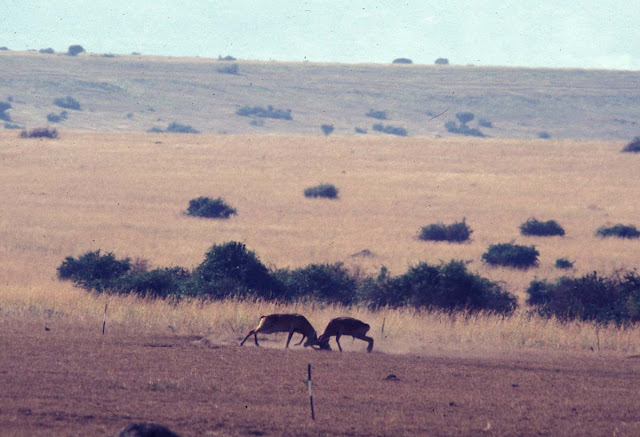
Two male Uganda kob sparring on the lek (mating ground)

July 10, 1971
Trip to Katwe to get our lump of beef at 4/50 shillings per kilo.


July 16, 1971
Awakened in night by violent thunderstorm. Next morning discovered Waser’s tent had blown down and everything got drenched so they spent the night in the VW. Marler’s tent also blew down but they were gone.

July 17, 1971
The other day we had a hard rain, which apparently signals the male termites to come out of the ground. So, in the middle of the night we were awakened by a din, caused by the Africans going out to collect the termites around the lights. In the morning, we saw bowls of them and discarded wings all over the ground. They fry the termites and it is a great delicacy!

July 19, 1971
In evening, Art and Beverly’s seminar on ants.

July 21, 1971
Vast colonies of army ants have made trails across the ground. They are the same ones Art and Beverly studied in the Kibale forest. They go out in a column five to twenty ants wide and throw up dirt on either side forming a trench. On either side “guard”ants stand with their pincers raised, seemingly against potential predators. [One day, Jennifer dropped her teddy bear onto an ant column, and the ants hung on so tight, that I had to cut out patches of the bear’s “fur” to remove them.]

July 24, 1971
In morning, took car trip with Marlers and Mary Sue around Royal Circuit hoping to see lions, but saw only lots of waterbuck and kob, a group of elephants with two babies and hippos at hippo pool.


July 25, 1971
Spent most of afternoon at swimming pool and treated ourselves to ice cream.
Mary Sue's Python
July 30, 1971
Last week Mary Sue and I found a nine foot long baby python. It had been speared through the head and left dead on the side of the road. I didn’t really want to touch it, but Mary Sue wanted to bring it back and skin it, so she did. The skin is really beautiful and will be a great souvenir to hang on her wall. We created quite a sensation by bringing it in and there was a whole crowd of people watching the skinning procedure. Afterwards it was rubbed down with salt, scraped, and dried.
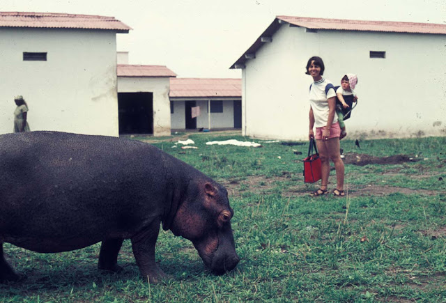
Caroline and Jennifer with baby hippo that was being hand raised by park staff
We are at the end of our stay here. This week Jennifer and I and Mary Sue went on two major sightseeing expeditions. Our first was hiring a Land Rover to take us to the craters, which turned out to be absolutely beautiful in the late afternoon sun. On the way we had two special treats. First, a group of elephants, which included a tiny baby nursing from its mother. The second was a pride of lions on a buffalo they had recently killed. This was the first time I’d seen lions doing anything but sleep (like house cats, they are basically rather lazy.) On Wednesday morning we took a boat trip up the channel. We saw all sorts of birds, lots of hippos, giant monitor lizards, plus elephant, buffalo, and bushbuck. It was a beautiful day and what made the trip most enjoyable was that Jennifer behaved well for the entire three hour ride.

July 30, 1971
Punch party at 6:00 in hostel with field course and NUTAE people.

(When the course was over, Art, Jennifer and I spent a week traveling in our rented VW through southwestern Uganda, up to but not across the borders to Burundi and Rwanda, and then back to Kampala.  In all, we spent nearly four months in East Africa.)


Update:  My friend Pat has traveled to Africa numerous times in recent years, sometimes staying at a private game reserve in South Africa called Leopard Hills.  Look at their blog for some amazing video of wildlife (lions, leopards, and more!) seen close up.

Tuesday, May 3, 2011

Walking the Cornwall Coast: Part I

A Week of Fresh Air and Ancient History (September 1998)
View of Tintagel from End of Rocky Valley
The slate cliffs of the Cornwall coast stretched for miles to the north and south, while the sparkling waves of the Atlantic Ocean disappeared beyond the western horizon. As I peered over the cliff edge into the rocky cove below it was easy to imagine pirates or smugglers stowing their booty in a secluded sea cave. Long ago I had fallen in love with this rugged southwest corner of England as I watched the adventures of Poldark on television and read Daphne du Maurier’s Rebecca. Now I was here and ready to embark with a friend on my first walking holiday.

I had often thought that a walking trip sounded like the perfect combination of exercise and scenery, and Cornwall seemed like the ideal place to start. Not only is its jagged coast spectacularly beautiful, but it has a proud and ancient heritage dating from Neolithic times. From mysterious stone circles in south Cornwall to the reputed birthplace of King Arthur at Tintagel, the walk promised intriguing peeks into history as well as abundant opportunities to enjoy nature.

The Southwest Coast Path
The Southwest Coast Path is a public hiking trail that runs continuously along the coasts of Cornwall and Devon for more than 500 miles. It is well marked and we quickly learned to look for the acorn signposts to point us in the right direction. The portions of the Coast Path that we hiked, between Newquay and Tintagel and near Penzance, were selected both because they promised good views and because there were villages at suitable intervals where we could stay each night. (We booked rooms ahead of time.) We planned our trip for September with the idea that we would miss the summer tourist crowds and still have a chance for good weather. As it turned out, we never had a drop of rain, and although I had packed warm clothes, I didn’t need them. Cornwall does have the mildest climate in all of Britain and likes to think of itself as the English Riviera.

Setting Off
Promenade in Newquay

We spent our first night in Penzance, and then took a bus to Newquay, where gracious old hotels look over a wide beach popular with surfers. As we stepped off the bus we nearly collided with a whiskered gentleman carrying a bell and wearing a tricornered hat, embroidered coat, and knee breeches. At first we thought we had somehow landed in the wrong century, but discovered that he was the official Town Crier. He struck up a conversation and when we told him that we planned to walk nine miles that day, he seemed dubious that we would make it at all. I suppose that we did look like an unlikely pair—two middle-aged women weighed down with heavy packs. He didn’t know that we both had been taking long walks to get in shape. When we told him our plans to walk north, he insisted that we were making a big mistake because, in his view, all the best scenery was to the south!

To Porthcothan
Just outside of Newquay we picked up the Coast Path and began our walk northward toward Porthcothan. In general, the path was level except when it dipped down to a beach and we had to walk across sand. Some of the ascents to the headlands were steep, but we just stopped frequently to admire the view, take a photo, and catch our breath.
Porthcothan

Much of the Coast Path hugs the top of the cliffs and was originally used by customs officers patrolling the beaches for smugglers. As we walked along, we looked down on seagulls, seals, and the occasional shipwreck. The Cornish coast is famous for its treacherous waters, and its rocky shores have claimed countless vessels. On the landward side of the path we looked inland over the green and gold patchwork of the Cornish countryside. Most of the landscape is open and grassy due to the more or less constant wind, but tucked against walls and in protected areas we also saw purple and yellow wildflowers, scarlet rose hips and ripening blackberries. People have been farming in Cornwall since the first settlers arrived from Europe about 5000 years ago. Today's farmers are encouraged to use traditional methods, so the farmsteads, with their sagging slate-roofed houses and enclosed fields, appear much as they have for hundreds of years. Ancient walls keep most animals in their cliff top pastures, but we occasionally passed a sheep grazing perilously on the seaward side.

Ancient Traditions
Cottage window, Mousehole

Celtic people came to Cornwall about 700 B.C., bringing with them the knowledge of iron making and Celtic traditions and language. “Cornwall” may come from the Cornish word “Cornovii” meaning “cliff castles.” In our walk we passed numerous Iron Age cliff castles and burial mounds, although to our inexperienced eyes, they usually looked more like grass covered lumps than ancient ruins.

Cornish, a language which is more like Welsh than English, was spoken in Cornwall until 250 years ago. It remains in place names such as Truro, the county seat of Cornwall, Delabole, which boasts Europe’s largest open slate quarry, and Penzance, the town made famous by composers Gilbert and Sullivan's Pirates of Penzance.

Shortcuts
Sharing the Path!

Occasionally we took alternate paths away from the cliff edge. Theoretically these were shortcuts, but were never marked as clearly as the Coast Path and usually required negotiating various stiles and crossing farmer’s fields. On one occasion we had a standoff with a herd of young steers but managed to get through with just being stared at.
We were not purists about walking every inch of the way or carrying our packs when it wasn’t necessary. After the first two days we were able to leave our packs at our hotel (or have them sent ahead by taxi) and then just used a small day pack for our raincoats (which we never needed) and our water and lunch. Even the tiniest villages had little cafes where we could stop for a cup of tea so we didn’t have to carry much food.

Cornish Pasties and Cream Teas
Exercise always guarantees a good appetite and for lunch we usually ate Cornish pasties, the hearty meat-filled pies that originated as a portable lunch for the local tin miners. Although the pasty—rhymes with “nasty”-- has become a fast-food staple in much of England, the best ones are still found in Cornwall. My hiking companion is of Cornish ancestry and told me that the thick dough enabled the pasty to be tossed down a mineshaft unharmed! The other food for which Cornwall is famous is clotted cream, a thick buttery spread that one slathers on fresh scones along with a dollop of strawberry jam.

Part II will cover stops in Padstow, Port Isaac, Tintagel, and walks near Penzance.
Go to the end of Part II for current information on getting to Cornwall, accommodations, and other details.

All text and photos copyright Caroline Arnold.

Walking the Cornwall Coast: Part II

Heading North

Lifeboat Station, Mother Ivey's Bay
Our second night was spent in Padstow, a quaint fishing village tucked into the side of the long estuary of the River Camel. As we walked the narrow cobblestone lanes of the town we discovered Prideaux Place, a small, but elegant, Elizabethan manor house overlooking a deer park. It is open to the public several days a week and has a tea shop.

The following morning we arrived at the harbor to find that the tide was out and that the boats were lying stranded in the sand, looking much like giant, comical insects. We followed the signs to the lower ferry landing to catch our ride across the estuary and then continued our walk northward toward Port Isaac, another historic fishing village. Cornwall’s fishing industry supplies much of Europe with seafood and provided us with many delicious dinners during our trip. Throughout our week in Cornwall we had tasty, freshly prepared food, but our dinner that night at the Port Gaverne Hotel, which included liver pate, a fresh fish platter, and a salad made with bacon and lightly sauteed scallops, was one of the best.

King Arthur (perhaps)
In addition to the natural beauty of the Cornish coast we saw the occasional lighthouse, castle and ancient ruin. The most spectacular ruin is at Tintagel, (pronounced tin TAJ el), where after climbing onto the rocky peninsula we found crenellated castle walls, an old church, an herb garden, and even the remains of a medieval toilet closet built into the castle wall at the edge of the cliff. Apparently the inhabitants hung clothes in the toilet closet because the smell kept out moths and other harmful insects!
Caroline at Tintagel

Tintagel is most famous as the reputed birthplace of King Arthur, although most historians discount any connection between the castle and the real Arthur, a Celtic warrior king who would have lived in the 6th century. The character that most of us know is a literary fiction created first by Geoffrey of Monmouth in the 12th century and popularized by Tennyson in the 19th century. Recently, however, an ancient slate, inscribed with a name that could refer to Arthur, was unearthed at Tintagel. It is the newest of a number of tantalizing clues that suggest there may be some truth to the legend. The real story may never be known, but the island ruins certainly provide a romantic setting for the tale and the village businesses capitalize on the connection. Other sights to see in or near Tintagel include the 11th century church of St. Materiana, the old post office, and Neolithic petroglyphs at Rocky Valley.

Penzance
Our last two nights were spent in Penzance. This town of 20,000 is on the west side of Mount’s Bay and has been a popular tourist destination since Victorian times when the railroad made it easy for people to get there from London. One still half expects ladies in long dresses and parasols to come strolling down the seaside promenade. Among the local attractions is the city park which features palm trees and other tropical plants.

Most visitors to Penzance make the ten-mile journey to Land’s End so they can have their photo taken at England’s most westerly point, but we decided to give Land’s End a miss when we heard that it is crowded and commercialized. Instead, we took a short bus ride to Marazion and walked across the causeway to St. Michael’s Mount, a tiny castle-topped island in the middle of the bay. The castle, originally built in the 12th century as a Benedictine Priory, is now owned by the St. Aubyn family. It is open to the public and provides breathtaking views across the water. We returned by boat because by afternoon, the tide had submerged the causeway.
Mousehole Harbor at Low Tide

The next day we walked from Penzance around the other side of the bay through Mousehole to Lamorna, one of the many artists’ colonies in Cornwall. Artists have long been attracted to Cornwall both because of its natural beauty and the brilliant light. Their work can be seen at numerous galleries and museums, including the Newlyn Art Gallery near Penzance and the Tate Gallery in St. Ives.

The Merry Maidens (Stone Circle at Lamorna)

The trip to Lamorna also included a visit to the Merry Maidens, a 4000-year-old stone circle, said to be young girls turned to stone because they were caught dancing on Sunday. In three adjacent fields, single standing stones are supposed to be the pipers who led them astray. South Cornwall has numerous Stone Age sites including other stone circles, as well as many burial chambers, holed stones, and quoits, or table stones.


A Cornish Mile
An overview of Cornwall’s long history can be seen at the beautiful Penlee House Museum in Penzance. There I read about a gentleman who visited Cornwall in 1602 and noted that it seemed as if “Cornish miles are much longer than those about London.” (They may have been, since distances had not yet been standardized.) I wondered if he had done a walking trip! There were a few times during our trip that I felt the distances seemed longer than those indicated on our maps, but perhaps that was because I stopped so often to admire the view. Every turn revealed a new perspective--a distant lighthouse, a natural stone archway, a hovering kestrel, or perhaps an abandoned flower field from the days when Cornwall provided London markets with early spring blooms. In our six days in Cornwall we saw a lot, but we still have a long list of things to do on another trip. Perhaps, next time we’ll head south as the Town Crier suggested.


Practical Considerations
(Although I walked the Cornwall Coast Path more than ten years ago, it is much the same today.  The following information is current.)
Getting there: There are several trains a day from Paddington Station in London to Penzance; from Heathrow, take a bus to Reading and catch the train from there. Train information in London is at 0345 484950. If you drive, take the A30 all the way from London to Penzance. Penzance is 280 miles southwest of London.
Getting around: Buses run frequently between most towns although less often on weekends. Taxis are also available.
Where to stay: Guides to bed and breakfasts in Britain are available from most large bookstores in the U.S. and from the AAA. Tourist Information Centers (TIC), located in most larger towns, can help you arrange accommodation. The TIC phone in Penzance is at 01736 362 207. In summer and holiday periods reservations are a must.
Hiking the Coast Path: I bought maps and guidebooks in London at a store called Stanfords at 12-14 Longacre Street WC2, but you can also find what you need at bookshops or outdoor suppliers in the larger towns of Cornwall. The South West Coast Path Association publishes a guidebook, see website below. (Some portions of the Coast Path are owned by the National Trust.) For short walks you can usually get maps and directions at your hotel or local TIC.

For a MAP and information on the SOUTH WEST COAST PATH go to http://www.southwestcoastpath.com/